Low pressure, forecast storms may enter the East Sea consecutively in September

Song Minh |

According to the latest storm forecast, in September, low pressure and 2-4 storms may appear continuously near the Philippines and the East Sea.

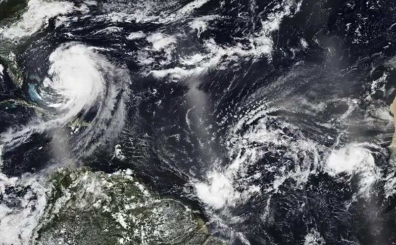
The Philippine Atmospheric, Geophysical and Astronomical Services Administration (PAGASA) forecasts that from now until the end of September, there may be 2 to 4 storms, most of which are likely to enter the East Sea. The resonance impact of the La Nina phenomenon has caused the risk of floods and landslides in the area to increase significantly.

Mr. Nathaniel Servando - Director of PAGASA - said that the first storm in September will be named Kiko. This could be the start of a series of low pressure and storms following each other due to the impact of La Nina, which is expected to form from this month and last until the end of the year.

La Nina will cause more than normal rainfall in most areas, while increasing the risk of flooding and landslides in vulnerable localities, Mr. Servando emphasized.

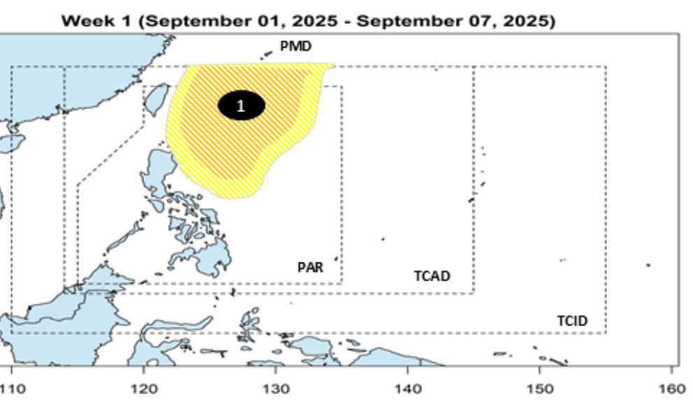
The latest typhoon bulletin from PAGASA said that during the week of September 1-7, a low pressure area will appear in the Philippine Forecast Area (PAR), likely moving south of Japan. PAGASA assesses the possibility of the low pressure strengthening into a tropical depression/storm at a low to medium level.

Du bao ap thap tuan tu ngay 1-7.9.2025. Anh: PAGASA
Low pressure forecast for the week of 1-7 September 2025. Photo: PAGASA

During the week of September 8-14, two other low pressure areas are forecast to form in the northern part of the Philippine Sea, including one low pressure area that is likely to move into the East Sea.

Du bao 2 ap thap tuan tu ngay 9-7.9.2025. Anh: PAGASA
Forecast of 2 low pressure areas per week from 8-14 September 2025. Photo: PAGASA

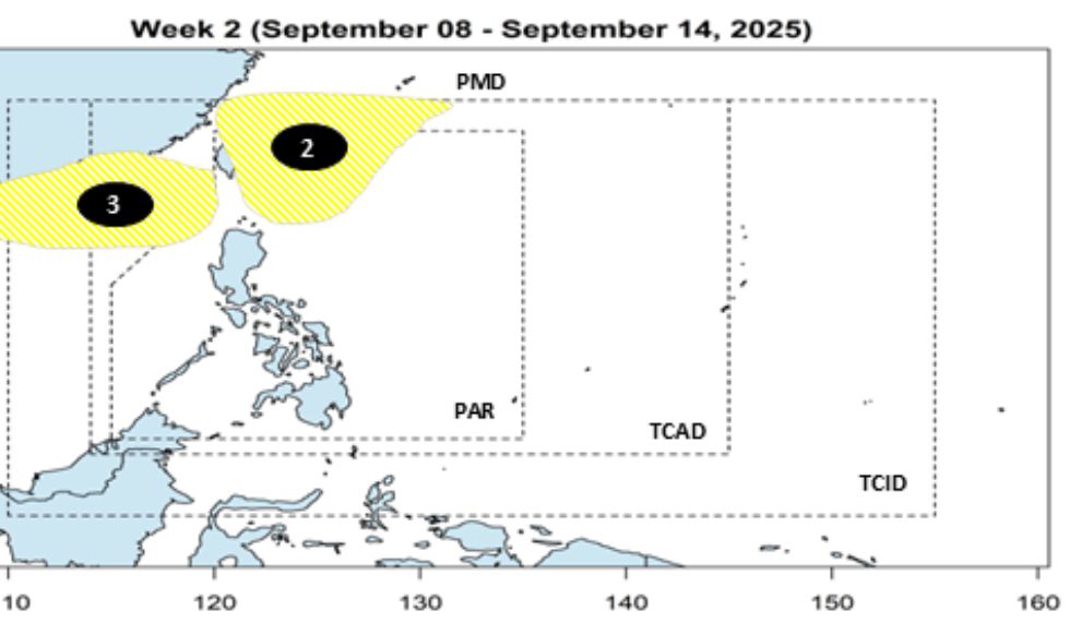
Although the possibility of these low pressure areas strengthening into storms is not high, PAGASA warns that they need to be closely monitored, as some formations may enter the East Sea and directly affect the area.

Current climate models show that the probability of a short-term La Nina from September to December is increasingly clear, with the possibility of exceeding 55%. Once this condition is maintained, the year-end storm season in the East Sea will be more complicated than the average of many years.

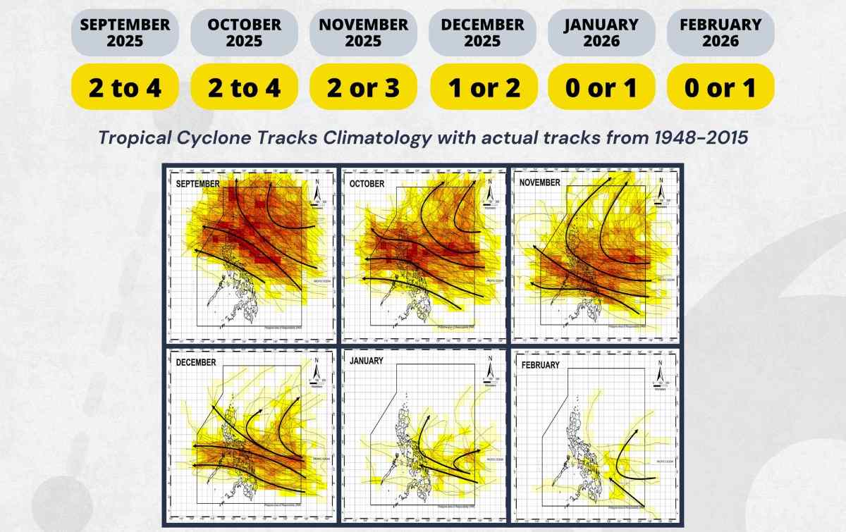
According to PAGASA, from September 2025 to February 2026, a maximum of 15 storms are forecast to form or enter the PAR area.

Duong di cua cac con bao tung vao PAR tu nam 1948 den 2015, cung so luong trung binh cac con bao xuat hien theo tung thang. Anh: PAGASA
Forecast the number of storms appearing each month from September 2025 to February 2026 and the path of storms that entered the PAR from 1948 to 2015. Photo: PAGASA

Faced with the risk of heavy rain and high-profile storms, the Philippine Meteorological Agency recommends that people not be subjective, and that local authorities proactively prepare early response scenarios.

Song Minh
RELATED NEWS

Storm season is at its peak, forecasting the time when low pressure will strengthen into storm No. 7 Gabrielle

|

The US National Hurricane Center (NHC) warns that a low pressure is likely to strengthen as it moves into the Atlantic, possibly becoming storm No. 7 Gabrielle.

Low pressure after storm No. 6 continues thunderstorms, warnings of tornadoes and flash floods during the September 2 holiday

|

After Typhoon No. 6 Nongfa has just dissipated, a new low pressure is forming, combined with the Southwest monsoon, bringing widespread thunderstorms right on the occasion of September 2.

The East Sea faces the risk of strong storms due to La Nina

|

La Nina could form before the end of 2025, increasing the risk of strong storms and heavy rains in the East Sea.

Uncle Ho's bodyguards were moved when witnessing the historic parade in Ba Dinh

|

Hanoi - Witnessing the historic parade at Ba Dinh Square on the morning of September 2, Mr. Le Binh (98 years old) could not help but be moved.

Countries send telegrams and letters congratulating Vietnam National Day

|

On the occasion of the 80th anniversary of Vietnam's National Day, Leaders of the countries sent telegrams and congratulatory letters to the leaders of the Party and State of Vietnam.

crossing mountains and forests to connect the 500kV Lao Cai - Vinh Yen transmission line

|

During the holidays, thousands of workers are still working hard to erect poles and pull ropes to soon open the entire 500kV Lao Cai - Vinh Yen route.

A80 parade: Happiness filled the air as seen from hospital windows

|

Hundreds of patients and their families from all departments of Xanh Pon General Hospital are looking at the windows to witness the A80 parade groups.

The female Major said that she felt the biggest pressure when she was the one who explained the opening ceremony of the A80 parade

|

As one of 13 people participating in the explanation team at the A80 mission, Major Ngoc Vu shared with Lao Dong reporter about the pressures, pride and emotions.

Storm season is at its peak, forecasting the time when low pressure will strengthen into storm No. 7 Gabrielle

Khánh Minh |

The US National Hurricane Center (NHC) warns that a low pressure is likely to strengthen as it moves into the Atlantic, possibly becoming storm No. 7 Gabrielle.

Low pressure after storm No. 6 continues thunderstorms, warnings of tornadoes and flash floods during the September 2 holiday

Khánh Minh |

After Typhoon No. 6 Nongfa has just dissipated, a new low pressure is forming, combined with the Southwest monsoon, bringing widespread thunderstorms right on the occasion of September 2.

The East Sea faces the risk of strong storms due to La Nina

Khánh Minh |

La Nina could form before the end of 2025, increasing the risk of strong storms and heavy rains in the East Sea.