Strong typhoon to enter Philippines forecast area today

Khánh Minh |

The Philippines is monitoring a strong typhoon, internationally named Bebinca, which is expected to enter the country's forecast area (PAR) today.

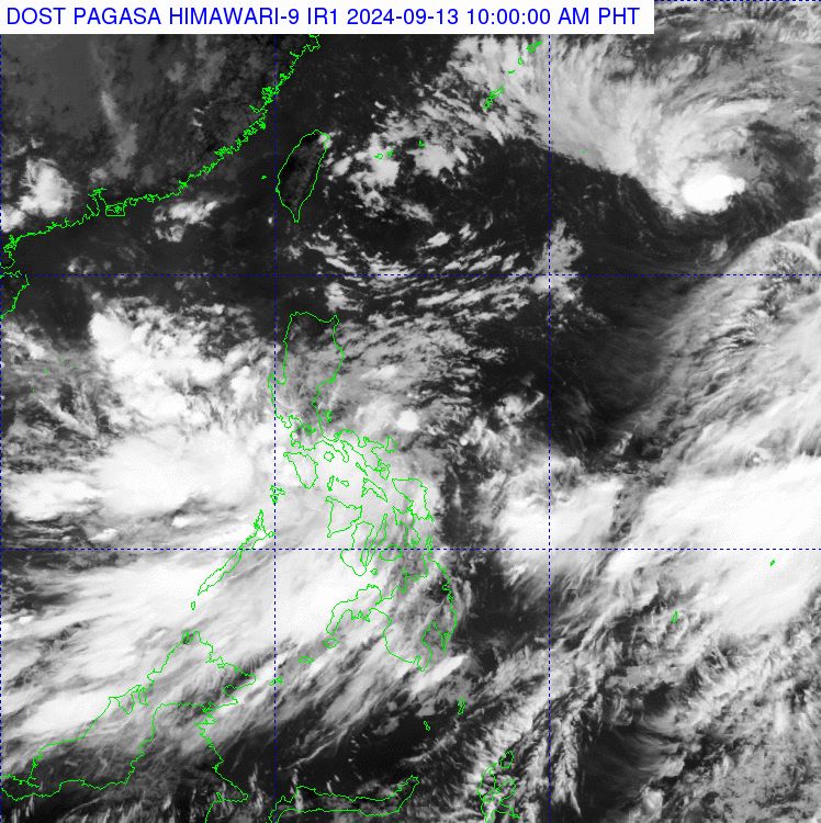
The Philippine Atmospheric, Geophysical and Astronomical Services Administration's storm forecast bulletin said that at 8:00 a.m. on September 13, the center of Bebinca was at approximately 22.1 degrees north latitude, 136.9 degrees east longitude, 1,565 km east of the northernmost tip of Luzon (outside the PAR forecast area). The strongest winds near the center of the storm reached 85 km/h, gusting to 105 km/h. The storm moved northwest at 20 km/h.

PAGASA forecasts that Typhoon Bebinca may enter PAR on September 13, when it will be locally named "Ferdie".

Due to the effects of the storm, strong winds and heavy rains, rough seas, and waves of 2.8-3.7m high are expected in eastern Visayas and Mindanao in the next 24 hours.

In Metro Manila, other parts of Luzon, Ilocos, Cordillera Administrative Region, Cagayan Valley, Quezon partly cloudy with scattered showers and thunderstorms.

PAGASA warns residents in these areas of the risk of flash floods or landslides.

Upon entering the PAR forecast area, Bebinca will become the sixth typhoon to affect the Philippines this year.

Anh: PAGASA
Satellite image of Typhoon Bebinca (top right corner) at 10:00 a.m. on September 13, 2024. Photo: PAGASA

Typhoon forecast models indicate that Typhoon Bebinca will approach Minamidaitojima, Japan early on September 14, with the potential to move northwest and approach the Amami Islands late on September 14.

Bebinca is expected to strengthen as it moves northwest across the East China Sea to southeastern China through September 15 before making landfall in Zhejiang Province early on September 16.

After making landfall, Bebinca is expected to rapidly weaken to a tropical depression as it moves west-northwest across Anhui Province through early September 18. There remains some uncertainty about the forecast track and intensity, and changes are possible in the coming days.

The Japan Meteorological Agency (JMA) has warned of strong winds and rough seas across the Amami and Okinawa regions through September 15. Waves as high as 9 meters and rainfall as high as 150 mm are forecast for September 14.

Prolonged heavy rains can cause flooding in low-lying areas and areas where drainage systems are easily overwhelmed. If conditions become hazardous, local evacuations, flash floods and landslides may occur.

Khánh Minh
RELATED NEWS

Storm No. 3 Yagi causes landslides, floods in Thailand

|

Due to the impact of storm No. 3 Yagi, northern Thailand suffered severe flooding and landslides.

New storm near Philippines on track to become typhoon

|

A tropical depression near the Philippines has strengthened into Typhoon Bebinca and is on track to continue to intensify.

Storm No. 6 evokes the haunting super typhoon of the strongest in the world 2024

|

Hurricane No. 6 Francine is being compared by many to the strongest superstorm Beryl in the world in 2024, making landfall in southeastern Texas (USA) on July 8.

Nearly 200 workers in Son La are waiting to be paid salaries near Tet

|

Son La - Nearly 200 workers in Chieng Khoong commune are waiting for the construction unit of the Primary - Secondary Inter-level Boarding School Project to pay wages on the eve of Tet.

Holding 1 million VND, still can't buy 1kg of Ca Mau crab on the eve of Tet

|

Some Ca Mau crabs have exceeded the 1 million VND/kg mark in the days leading up to the Binh Ngo Lunar New Year 2026.

On the 27th of Tet, the southern gateway of Hanoi is not congested

|

Hanoi - On the first day of the 9-day Tet holiday, the volume of vehicles leaving the capital increased sharply, but traffic at the southern gateway was still smooth, without congestion.

Workers wake up at 4 am, excitedly returning to their hometowns on a trade union bus

|

Hai Phong - On the morning of February 14, hundreds of workers boarded a bus to return to their hometowns to celebrate Tet organized by the Trade Union of Yazaki Hai Phong Vietnam Co., Ltd.

Fishing boats dock at the end of the year, ready for the first spring sea trip

|

Can Tho - After many long days of sticking to the fishing grounds, fishermen's fishing boats have returned to shore to celebrate Tet and prepare for the first sea trip of the new year.

Storm No. 3 Yagi causes landslides, floods in Thailand

Song Minh |

Due to the impact of storm No. 3 Yagi, northern Thailand suffered severe flooding and landslides.

New storm near Philippines on track to become typhoon

Khánh Minh |

A tropical depression near the Philippines has strengthened into Typhoon Bebinca and is on track to continue to intensify.

Storm No. 6 evokes the haunting super typhoon of the strongest in the world 2024

Ngọc Vân |

Hurricane No. 6 Francine is being compared by many to the strongest superstorm Beryl in the world in 2024, making landfall in southeastern Texas (USA) on July 8.