At 2:00 p.m. on August 24, the Japan Meteorological Agency (JMA) said it had upgraded the Kajiki typhoon to a Category 13-14 intensity, gusting to level 17.
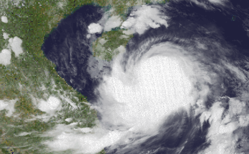
The Kajiki storm continuously entered the eye replacement cycle in the morning and afternoon of August 24, with convective clouds around the eye also thicker and thicker. The eye of storm No. 5 is getting sharper and sharper on satellite cloud images.
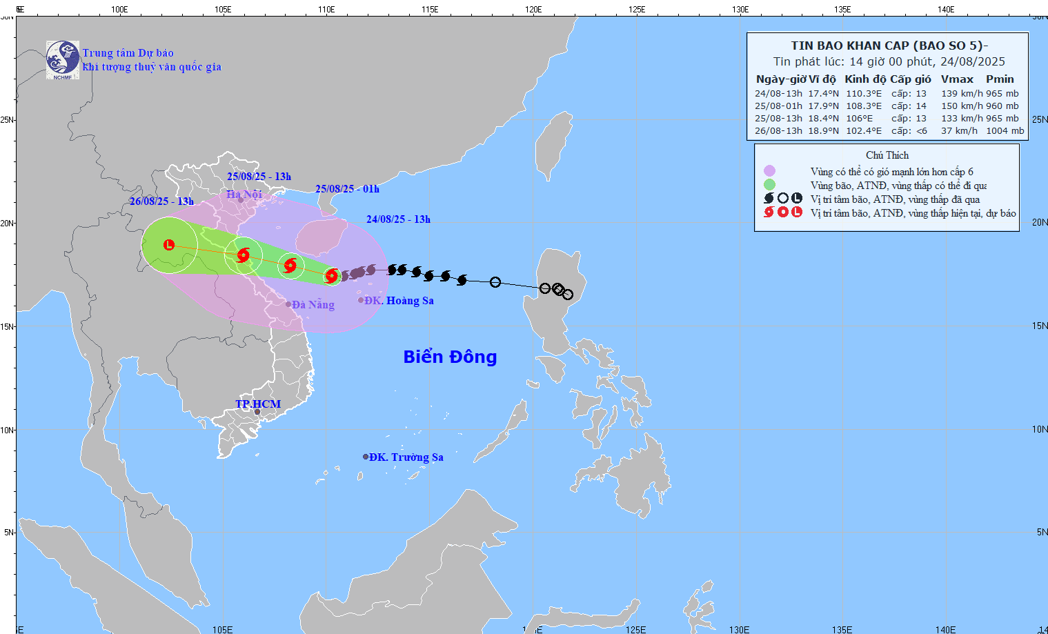
According to the Vietnam National Center for Hydro-Meteorological Forecasting, at 4:00 p.m. on August 24, the center of storm No. 5 in the East Sea was at 17.6 degrees North latitude, 109.9 degrees East longitude, 470km from Nghe An, 450km from Ha Tinh, 390km east of Bac Quang Tri.
The strongest wind near the storm center is level 13-14 (134-166 km/h), gusting to level 16. The storm is moving westward at a speed of 20 km/h and is likely to strengthen.
It is forecasted that by 4:00 a.m. on August 25, the storm will move in a West-Northwest direction, about 20 km/h, into the South Gulf of Tonkin. The center of the storm is located at 18.0 degrees North latitude, 107.9 degrees East longitude, 240km from Nghe An, 210km from Ha Tinh, and 140km from Bac Quang Tri. Storm intensity level 13-14, gust level 16.
By 4:00 p.m. on August 25, storm No. 5 was on land from Thanh Hoa to Quang Tri, coordinating 18.5 degrees North latitude, 105.6 degrees East longitude. The intensity decreased to level 11-12, gusting to level 14.
At 4:00 p.m. on August 26, the storm moved to Central Laos, at 19.0 degrees North latitude, 102.1 degrees East longitude, weakening rapidly below level 6.
Due to the impact of the storm, in the Northwest of the East Sea (Hoang Sa), there will be winds of level 9-11, near the center of the storm level 12-14, gusting to level across; waves 5-7m high, near the center of the storm waves 8-10m high; the sea will be very rough.
The sea area of Thanh Hoa - Hue (hon Ngu, Con Co) has strong winds of level 7-9, increasing to level 10-11, near the center of the storm level 12-14, gusting to level 16: waves 5-7m high, near the center of the storm waves 8-10m; the sea is very rough.
The North Gulf of Tonkin (Cat Hai, Co To, Van Don) has winds of level 6-7, gusting to level 9; the South (Bach Long Vi) has winds of level 8-9, gusting to level 11. The waves are 2.5-4.5m high; the sea is very rough.
Regarding heavy rain forecast: From the evening of August 24 to the end of August 26, in the Northern Midlands and Delta, Lao Cai, Thanh Hoa - Hue, there will be rain of 100-150mm, locally >250mm.
Thanh Hoa - North Quang Tri, very heavy rain 200-400mm, locally >700mm. Warning of the risk of extremely heavy rain (>200mm in 3 hours).
Hanoi: moderate to heavy rain, thunderstorms. Da Nang: rain and thunderstorms from the night of August 24-25. Ho Chi Minh City has showers and thunderstorms on the evening of August 24-26.
At noon on August 24, the Hong Kong Observatory (China) canceled all tropical cyclone warning signals as Typhoon Kajiki moved away from this special administrative region.
At 4:00 p.m. the same day, the center of Typhoon Kajiki was about 120 km southeast of Tam A (Hainan, China). The storm is forecast to move through the sea area south of Hainan Island.
Meanwhile, the Thai Meteorological Agency warned that Typhoon Kajiki will bring heavy rain to northeastern Thailand from August 24-26.