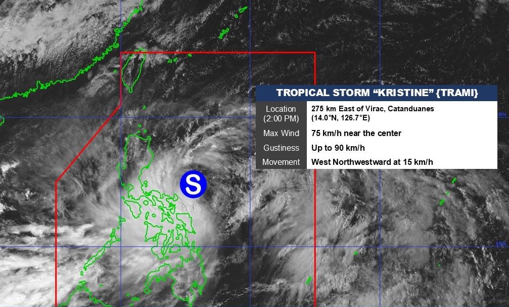
The latest storm information from the Philippine Atmospheric, Geophysical and Astronomical Services Administration (PAGASA) said that at 2:00 p.m. on October 22, the center of storm Tra Mi (local name Kristine) was at about 14 degrees north latitude, 126.7 degrees east longitude, in the sea east of the central Philippines, 275km east of Virac, Catanduanes.
The strongest wind near the storm center is 75 km/h, gusting to 90 km/h. The storm is moving northwest at 15 km/h.
PAGASA warned that strong winds and high waves will occur in some Philippine waters in the next 24 hours, thus calling on all vessels, crews and tourists at sea to quickly seek safe shelter or stay in ports.
Typhoon Kristine continued to bring heavy rains on October 22, causing flooding in San Isidro, Naga City. Passengers stranded in Pio Duran, Albay had to take shelter at Panganiran Elementary School, according to Rappler.
According to the Catubig City Information Office, at least 21 villages in Catubig, Northern Samar, were partially flooded as of 1 p.m. on October 22.
Almost all of Luzon was affected by strong winds from the typhoon.
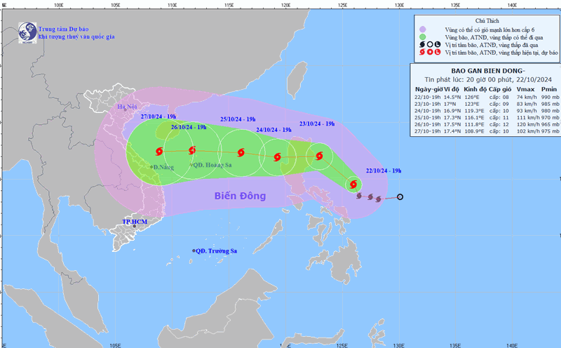
According to the Vietnam National Center for Hydro-Meteorological Forecasting, as of 1 p.m. on October 25, the center of storm Tra Mi is forecast to be at about 17.6 degrees north latitude, 117.0 degrees east longitude; in the eastern sea of the North East Sea, 550km east-northeast of the Hoang Sa archipelago.
The strongest wind near the storm center is level 11, gusting to level 14, moving mainly west at about 15km/h, entering the East Sea.
From the next 72 to 120 hours, the storm will move mainly westward, traveling 15-20km per hour, and will continue to strengthen.
The sea area east of the northern East Sea has strong winds of level 6-7. From the morning of October 24, it will increase to level 8-9, near the storm center it will be level 10-11, gusting to level 14, waves 4-6m high, near the center 6-8m; the sea will be very rough.
Ships operating in the above mentioned dangerous areas are susceptible to the effects of storms, whirlwinds, strong winds and large waves.
According to the Storm page on the Northwest Pacific, Tra Mi is currently forecast to be a strong storm that could threaten the Central Central region. However, the storm has not yet entered the East Sea, so it is necessary to monitor changes in the coming time.