The latest typhoon information from the Philippine Atmospheric, Geophysical and Astronomical Services Administration (PAGASA) said that the number of storms entering or forming in the Philippine forecast area this year will be average or lower than normal.
We have not seen any yet, so the number of storms could be below average or near average, said Ana Liza Solis, PAGASAs Chief Climate Monitoring and Forecasting Director.
She also noted that the rainy season in the Philippines has not yet begun, as regular rain and winds blowing from the west are the official sign of the rainy season.
Its not the rainy season yet, although there has been rain in the afternoon and evening, especially in Metro Manila and other parts of Luzon. However, no monitoring station has met all the criteria to announce the start of the rainy season," PAGASA's weather forecaster stressed.
According to typhoon forecasters, one to two typhoons are expected to form in the Philippine forecast area in May. Benison Estareja, a weather expert at PAGASA, said that the first storm will be named Auring, followed by Bising.
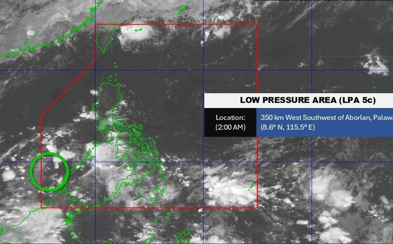
According to PAGASA's regular typhoon forecast bulletin published on May 19, it is forecasted that during the week from May 19 to 25, a low pressure will form in the Sulu Sea area, near Palawan, Philippines.
Forecast models show that this low pressure near the East Sea will leave the Philippine PAR forecast area and enter the East Sea.
In the week from May 26 to June 1, the low pressure is expected to enter the East Sea, operating mainly in the northern part of the East Sea, then turn towards Taiwan (China).
In general, during the forecast period, the possibility of this low pressure in the East Sea strengthening into a storm is low.
In the forecast for the 2025 typhoon season, PAGASA said that by September, there may be 8 to 14 storms entering or forming in the PAR. Of these, one to two are expected in June, and two to three per month in July, August and September.
Regarding temperature trends, most areas of the Philippines will have warmer-than-average surface temperatures. Some areas in Luzon and the Visayas may experience significantly higher temperatures, exceeding normal by 2 degrees Celsius.
The neutral phase of ENSO ( El Nino - Southern fluctuations) is affecting the Pacific Ocean mainly at the present time, making the weather in the region not as hot as El Nino or as cold as La Nina.
Normally, when La Nina dominates, tropical storm activity in the Philippines' forecast area can be more intense.