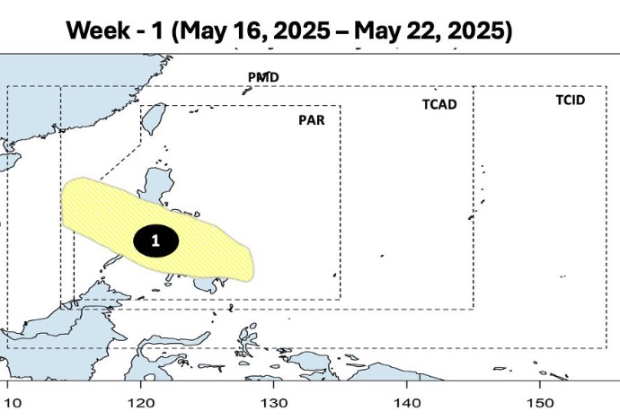
The latest storm and low pressure information on May 16 from the Philippine Atmospheric, Geophysical and Astronomical Services Administration (PAGASA) said that it is forecasted that during the week from May 16 to 22, a tropical depression will form within the Philippine Forecast Area (PAR).
Philippine typhoon forecasters say the low pressure is likely to form near eastern Mindanao, Visayas and Southern Luzon in the Philippines.
Forecast models show that the depression will move northwest, pass over the Philippine mainland and enter the East Sea. However, during the forecast period, the low pressure is unlikely to strengthen into a storm.
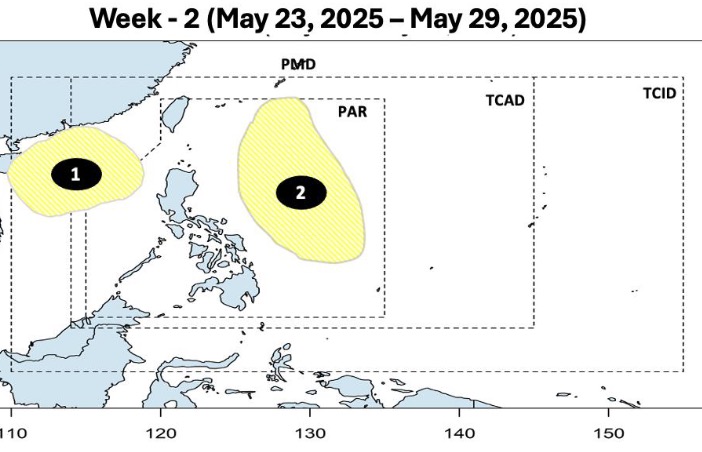
During the week from May 23 to May 29, the low pressure near the East Sea formed last week is forecast to continue to operate after entering the East Sea. Although it is still unlikely to strengthen into a storm, this low pressure will continue to operate in the northern part of the East Sea during the forecast period.
In addition, at the same time in the South China Sea, a new low pressure will also form near the South China Sea. The second low pressure is likely to appear on the eastern boundary of PAR with low ability to become storms. Forecasters say that this low -pressure low -sea will move north and operate mainly in the Philippines in the forecast period.
In May, storms and tropical depressions in the Philippines will have two main movements, according to PAGASA.
Philippine experts point out that the common direction of storms and depressions in May includes:
First, the storm formed in the western Pacific, entering the PAR forecast area but then loops out to sea instead of making landfall in the Philippines.
Second, the storm formed in the western Pacific, entered PAR and then made landfall in the central Philippines. From here, the low pressure will enter the East Sea but quickly rotate northeast, leaving the PAR.
In the regular May weather forecast, PAGASA weather expert Benison Estareja predicted that the likelihood of typhoons will increase as the Philippines is entering the typhoon season. In May 2025, PAGASA forecasts that there will be 1 or 2 tropical storms forming. The first storm will be named Auring, followed by Bising.
The northwest Pacific, including the Philippines, typically experiences typhoons from May to November.
Classify storms and tropical depressions in the Philippines based on wind power. According to PAGASA's classification system, the tropical depression has maximum sustained winds of up to 62 km/h. The tropical storm has a maximum wind speed of 62 to 88 km/h. A severe tropical storm has a maximum wind speed of 87 to 117 km/h. Typhoons have a maximum wind speed of 118 to 184 km/h while super typhoons have a maximum wind speed of 185 km/h or more.