The latest storm information from the Philippine Atmospheric, Geophysical and Astronomical Services Administration (PAGASA) said that at 5:00 p.m. on November 2, typhoon Kalmaegi (local name: Tino) strengthened into a severe tropical storm.
At 7:00 p.m. on November 2, the center of the storm was at about 11.3 degrees north latitude; 131.2 degrees east longitude, in the sea east of the central Philippines. The strongest wind near the storm center is level 10 (89-102 km/h), gusting up to 115 km/h, and can increase to 150-165 km/h before making landfall.
PAGASA warned that Typhoon Kalmaegi could undergo rapid intensification in the next 24-48 hours, with the potential to reach super typhoon level. Scenarios based on climate data show that the possibility of storms exceeding this threshold cannot be ruled out.
Dinagat Islands Governor Nilo Demerey, Jr., has stressed the need to prepare for the storm. He said the storm's strength is similar to that of Odette (Rai) in December 2021 and its trajectory is similar to the path of super typhoon Yolanda (Haiyan - super typhoon Hai Yen, Vietnam identified as storm No. 14 in 2013) in November 2013.
Super typhoon Hai Yen is one of the largest and strongest storms in the world to ever be recorded based on wind speeds when making landfall, equivalent to more than 313 km/h.
Typhoon Kalmaegi is forecast to make landfall first in eastern Samar or Dinagat Island on the night of November 3 or early morning of November 4, then move through the Visayas region, North Palawan, and then move out to the East Sea on November 5.
According to the Vietnam National Center for Hydro-Meteorological Forecasting, by 7:00 p.m. on November 3, the center of the storm is forecast to be at 10.8 degrees north latitude; 126.3 degrees east longitude; in the sea east of the central Philippines, level 12 intensity, gust level 15.
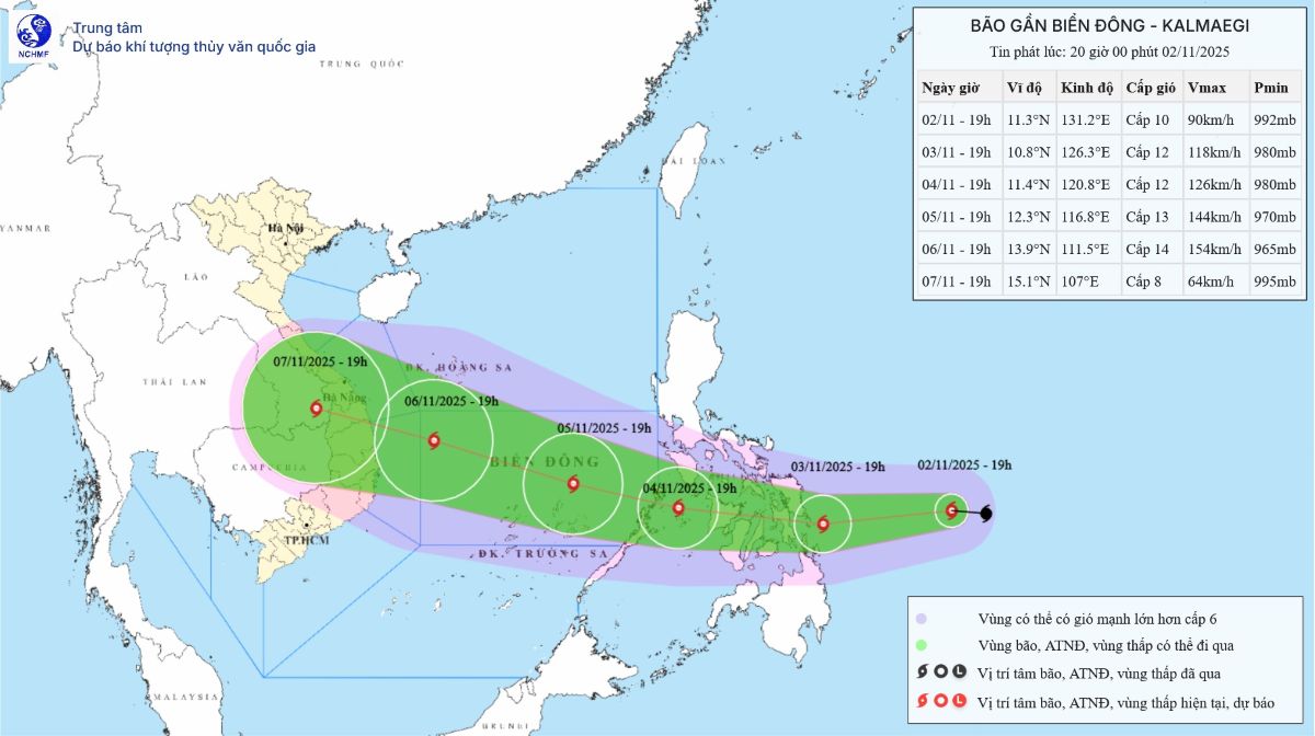
At 7:00 p.m. on November 5, the center of the storm was at 12.3 degrees north latitude; 116.8 degrees east longitude, in the central East Sea, with an intensity of level 13, gusting to level 17.
From around the afternoon of November 4, the sea area east of the central East Sea will have winds gradually increasing to level 6-7, then increasing to level 8-9; the area near the storm center will be strong at level 10-12, gusting to level 14-15, waves 5.0-7.0m high. The sea is rough.
Warning that around November 5-6, the central East Sea area (including Truong Sa special zone), the sea off the Da Nang - Khanh Hoa area is likely to be affected by strong winds of level 12-14, gusts above level 17, waves 8.0-10.0m high. The sea is rough
All ships and works operating in the above-mentioned danger zone are affected by very strong impacts of thunderstorms, whirlwinds, strong winds, and large waves.