The latest storm information from the Philippine Atmospheric, Geophysical and Astronomical Services Administration (PAGASA) said that at 10:00 a.m. on November 24, the center of tropical depression Verbena was at about 9.3 degrees north latitude; 127.3 degrees east longitude, 205km east-northeast of Surigao City, Surigao del Norte Province.
Maximum winds near the center of the tropical depression are 45 km/h, gusting to 55 km/h, central pressure 1002 hPa.
The tropical depression is moving westward at a speed of 15 km/h. The range of strong winds is 200km from the center.
The tropical depression is expected to cause widespread heavy rain in the Philippines. International storm forecast models show that the system is likely to strengthen into storm No. 15 and reach its peak when it moves out to the East Sea around Thursday (November 27).

Scenarios agreed upon by most international storm forecasting models:
Tuesday (November 25): Strengthens into storm Verbena when it reaches the Bohol Sea
Wednesday (November 26): Continued to strengthen after entering the East Sea, above the Truong Sa archipelago, becoming storm No. 15, international name Koto.
Thursday (November 27): maximum level, ranging from level 10-12. The reason is that the sea water in this area is still too warm (28-29 degrees Celsius) and there are quite few wind shear, which is favorable for the storm to intensify.
Friday (November 28): Changing the direction of the sea route to the west-southwest, towards the South Central Coast of Vietnam and reducing the intensity due to the cold air mass and cold sea water (26-28 degrees Celsius due to the recent heavy rain in the South Central Coast). The movement may be blocked by a high-pressure tongue wall of cold air near the shore from around November 28. The situation of wind shear has also increased.
Global meteorological forecasters are warning of an extreme cyclone in the Arctic, affected by severe cold spells in Siberia in Russia and northern China right after Thanksgiving Day (November 27). That will affect cold air waves in the North and Central regions of Vietnam from that time.
Meanwhile, the Vietnam National Center for Hydro-Meteorological Forecasting said that by 7:00 a.m. on November 25, the center of the tropical depression is forecast to be at 11.0 degrees north latitude, 123.1 degrees east longitude; in the central Philippines. Intensity level 7, gust level 9. Moving west-northwest, about 20-25 km/h.
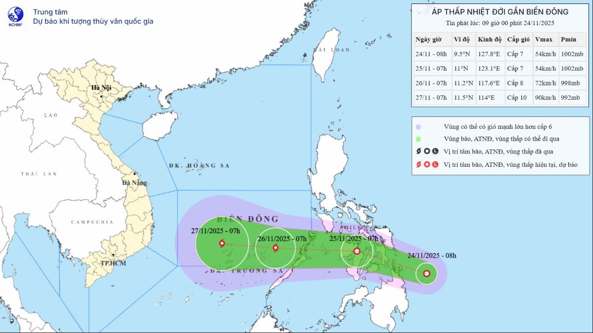
At 7:00 a.m. on November 26, the center of the tropical depression was at 11.2 degrees north latitude, 117.6 degrees east longitude; in the southeastern sea area of the central East Sea. There is a possibility of strengthening into a Category 8 storm, gusting to level 10. Moving westward, about 20-25 km/h, it will enter the East Sea, becoming storm No. 15.
Forecast of the impact of tropical depression/storm: Strong winds, big waves
From the evening of November 25, the sea area east of the central and southern East Sea will have winds gradually increasing to level 6-7; the area near the storm center will have strong winds of level 8, gusts of level 10, waves 3.0-5.0m high. Strong seas.
During the night of November 26-28, the central and southern East Sea (including the northern sea area of Truong Sa) is likely to be affected by strong winds of level 9-10, gusting to level 13.
Ship operating in the above-mentioned dangerous areas are likely to be affected by thunderstorms, whirlwinds, strong winds, and large waves.


