Warning of low pressure area in the southern East Sea

Song Minh |

A low pressure area in the southern South China Sea, northwest of Borneo island is creating a large area of ​​showers and thunderstorms.

The Joint Typhoon Warning Center (JTWC) forecast bulletin on October 18 said that low pressure in the northwest of Borneo island, south of the East Sea is creating a large area of ​​showers and thunderstorms.

Environmental conditions are expected to be favorable for gradual development and the system may become a tropical depression early next week as it crosses the Malay Peninsula and exits the Western Pacific basin. The JTWC assesses the chance of intensification over the next 7 days as moderate (40%).

On the same day, the Vietnam National Center for Hydro-Meteorological Forecasting also said that currently (October 18), in the southern East Sea area (including the waters of the Truong Sa archipelago), the waters from Binh Thuan to Ca Mau and the Gulf of Thailand, there are scattered showers and thunderstorms.

Forecast for the day and night of October 18, the southern sea area of ​​the central East Sea, the southern East Sea area (including the sea area of ​​Truong Sa archipelago), the sea area from Khanh Hoa to Ca Mau, Ca Mau to Kien Giang and the Gulf of Thailand will have scattered showers and thunderstorms.

During thunderstorms, there is a possibility of tornadoes and strong gusts of wind of level 7-8. All vessels operating in the above areas are at risk of being affected by tornadoes and strong gusts of wind.

Dong chay tai tang mat cac vung bien ngay 17.10.2024. Anh: Trung tam Du bao khi tuong thuy van quoc gia Viet Nam
Surface flows in sea areas on October 17, 2024. Photo: Vietnam National Hydrometeorological Forecasting Center

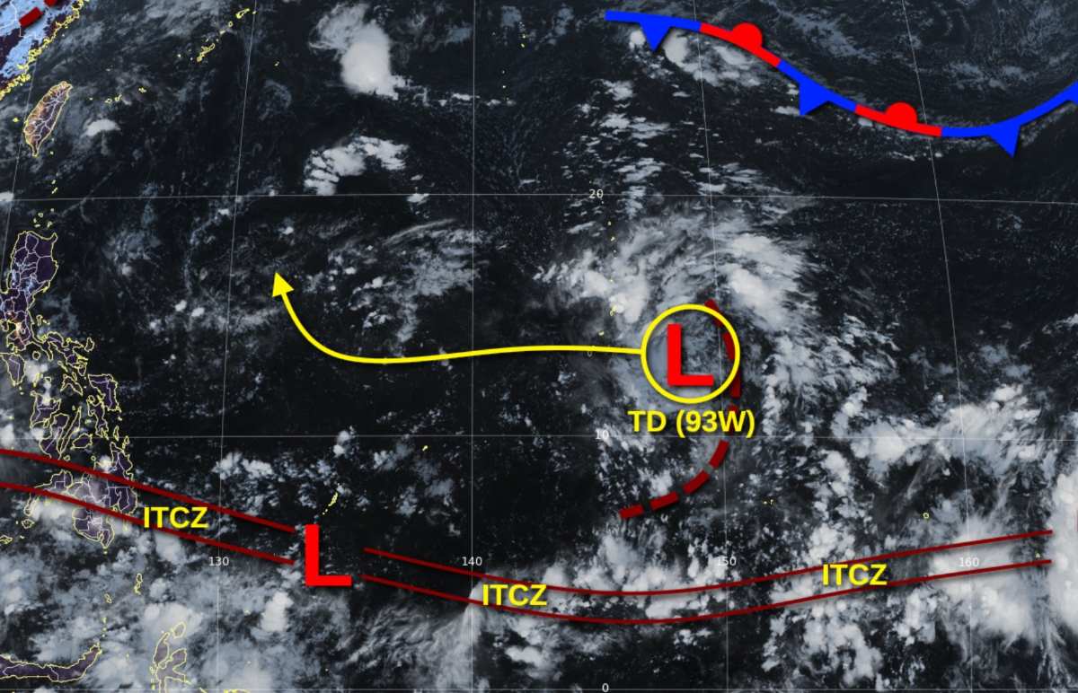
On October 18, JTWC also monitored two other low pressure systems operating in the Western Pacific.

Tropical Depression Invest 93W is currently located near Guam Island (USA). This system has a low chance of developing into a tropical cyclone in the next 24 hours.

Maximum winds near the center of the tropical depression are about 30 km/h. Minimum sea level pressure is estimated at nearly 1,009 hPa.

Ap thap nhiet doi 93W. Anh: JTWC
Tropical Depression 93W. Photo: JTWC

The second tropical depression - Invest 94W - is currently located near the Northern Mariana Islands. The system has a low chance of developing into a tropical cyclone in the next 24 hours.

The strongest wind speed near the center of tropical depression Invest 94W is about 25-35 km/h. The estimated minimum sea level pressure is near 1,006 hPa.

Ap thap nhiet doi 94W gan du kien di chuyen ve Bien Philippines. Anh: Zoom Earth
Tropical Depression 94W near the Northern Mariana Islands is expected to move toward the Philippine Sea. Photo: Zoom Earth

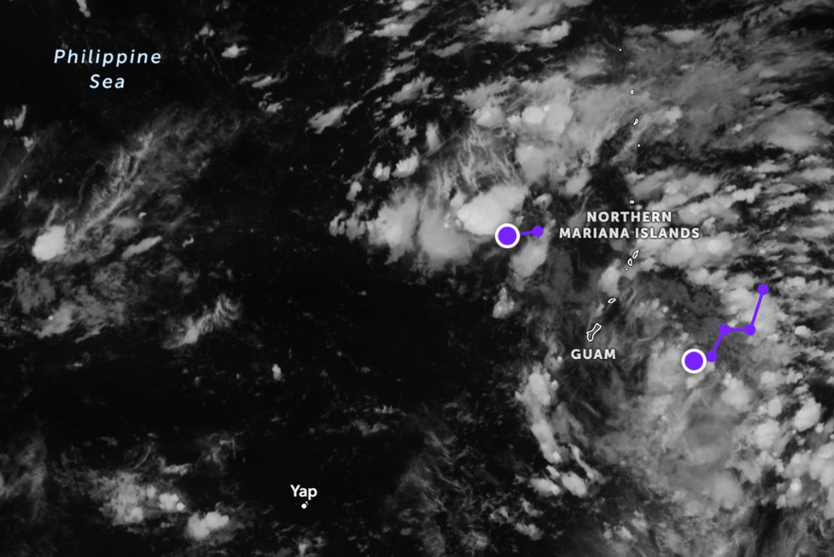
Favorable conditions for development with low wind shear (18-28 km/h) and very warm sea surface temperatures (31 degrees Celsius) will support the development of this tropical depression in the coming days.

Storm forecast models show tropical depression Invest 94W moving southwest toward the Philippine Sea in the next 24 hours.

Song Minh
TIN LIÊN QUAN

Forecast of the possibility of 2 new storms appearing in the second half of October

|

According to the latest storm forecast, after the recent catastrophic super storms, two new storms may appear in the second half of October.

Low pressure forecast near East Sea

|

According to the latest storm/low pressure forecast, a low pressure near the East Sea is likely to appear in the next few days.

Forecast of new storm near East Sea

|

The 2024 hurricane season is far from over as hurricane forecasters have already pinpointed when the next storm will appear.

Storm Tra Mi is forecast to move quickly and continuously strengthen in the East Sea

|

The meteorological agency forecasts that after entering the North East Sea, storm Tra Mi is likely to strengthen.

Nhan Dan Newspaper launches National Brands page

|

On the afternoon of October 22, Nhan Dan Newspaper in collaboration with the Ministry of Industry and Trade launched the National Brand page, providing comprehensive data on leading enterprises.

Import and export exceed 600 billion USD, forecast to have many more records

|

As of mid-October, the country's total import-export turnover reached 610.56 billion USD, with a trade surplus of 21.24 billion USD. It is forecasted that it could reach 800 billion USD by the end of the year.

Secretly recording the handling of the "chaotic" passenger bus at Thang Long bridge

|

Hanoi Traffic Police will increase patrols, disguise themselves, and secretly record and handle passenger vehicles stopping and parking at the Thang Long Bridge.

Proposing China to properly handle the issue of fishing boats and fishermen

|

Vietnam requests that China properly handle the issue of fishing vessels and fishermen; respect each other's legitimate and legal rights and interests.

Forecast of the possibility of 2 new storms appearing in the second half of October

Khánh Minh |

According to the latest storm forecast, after the recent catastrophic super storms, two new storms may appear in the second half of October.

Low pressure forecast near East Sea

Khánh Minh |

According to the latest storm/low pressure forecast, a low pressure near the East Sea is likely to appear in the next few days.

Forecast of new storm near East Sea

Khánh Minh |

The 2024 hurricane season is far from over as hurricane forecasters have already pinpointed when the next storm will appear.