According to the latest storm information from the US National Hurricane Center (NHC) at 11:00 p.m. on August 24 (Eastern time, US), tropical storm Fernand was identified about 515km east of Bermuda, with maximum sustained winds of 80 km/h. The storm is moving north-northeast at a speed of 21 km/h, with strong tropical winds that can extend up to 95 km from the center of the storm.
Fernand is the sixth storm of the 2025 Atlantic hurricane season, which formed shortly after Hurricane Erin on August 15. Fernand is forecast to continue to strengthen on August 25 but is likely to weaken from the evening of the same day or until August 26, as it will only operate in the sea off the coast.
While Fernand has not dissipated, the NHC said it is closely monitoring a new weather disturbance coded Invest 99L, which is approaching the Windward Islands and the Caribbean Sea.
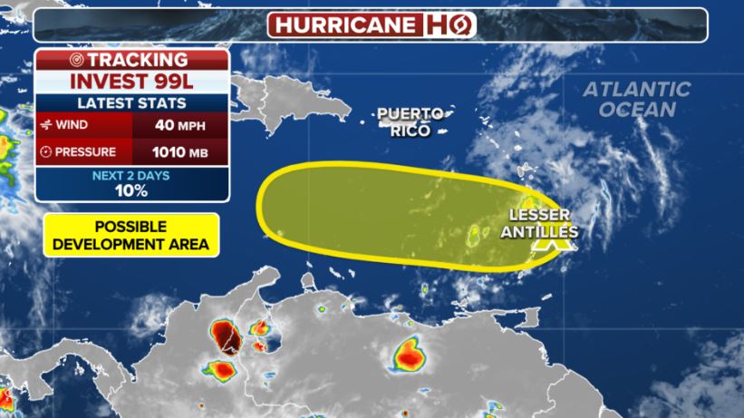
Invest 99L is causing thunderstorms, but there is no clear circulation. To verify, US hurricane fighters have been dispatched for survey. If qualified, Invest 99L can develop into a low pressure area and strengthen into a tropical depression in the next 1-2 days.
The system is expected to move rapidly at a speed of 32-40 km/h, crossing the Windward and Leeward Islands on August 25, then entering the central Caribbean Sea on August 26. However, atmospheric conditions in this area are said to be less favorable for storm formation.
Despite low development potential, the Invest 99L could still bring localized heavy rains and strong winds to many islands in the Caribbean.
The National Oceanic and Atmospheric Administration (NOAA) predicts that this year's Atlantic hurricane season will be complicated with the number of storms exceeding the average of many years. 13 to 18 named storms are expected to form, including five to nine that have reached typhoon status.
The continuous follow-up of Hurricane Fernand after Erin, along with the appearance of the Invest 99L low pressure area, is showing that the Atlantic region is entering the peak of the hurricane season with the risk of extreme weather.
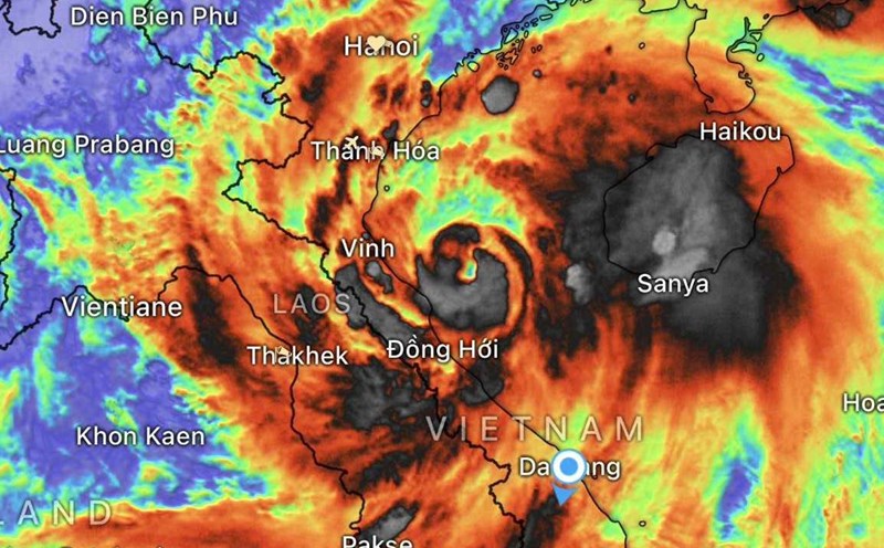
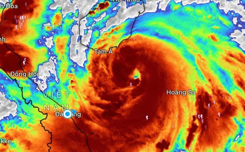
Meanwhile, in Vietnam, storm No. 5 Kajiki entered the coastal waters of Nghe An - Ha Tinh since the afternoon of August 25, with the center of the storm at about 18.5 degrees North latitude; 106.3 degrees East longitude. The strongest wind near the storm center is level 13 (134-149 km/h), gusting to level across; moving in the West Northwest direction at a speed of 15-20 km/h.
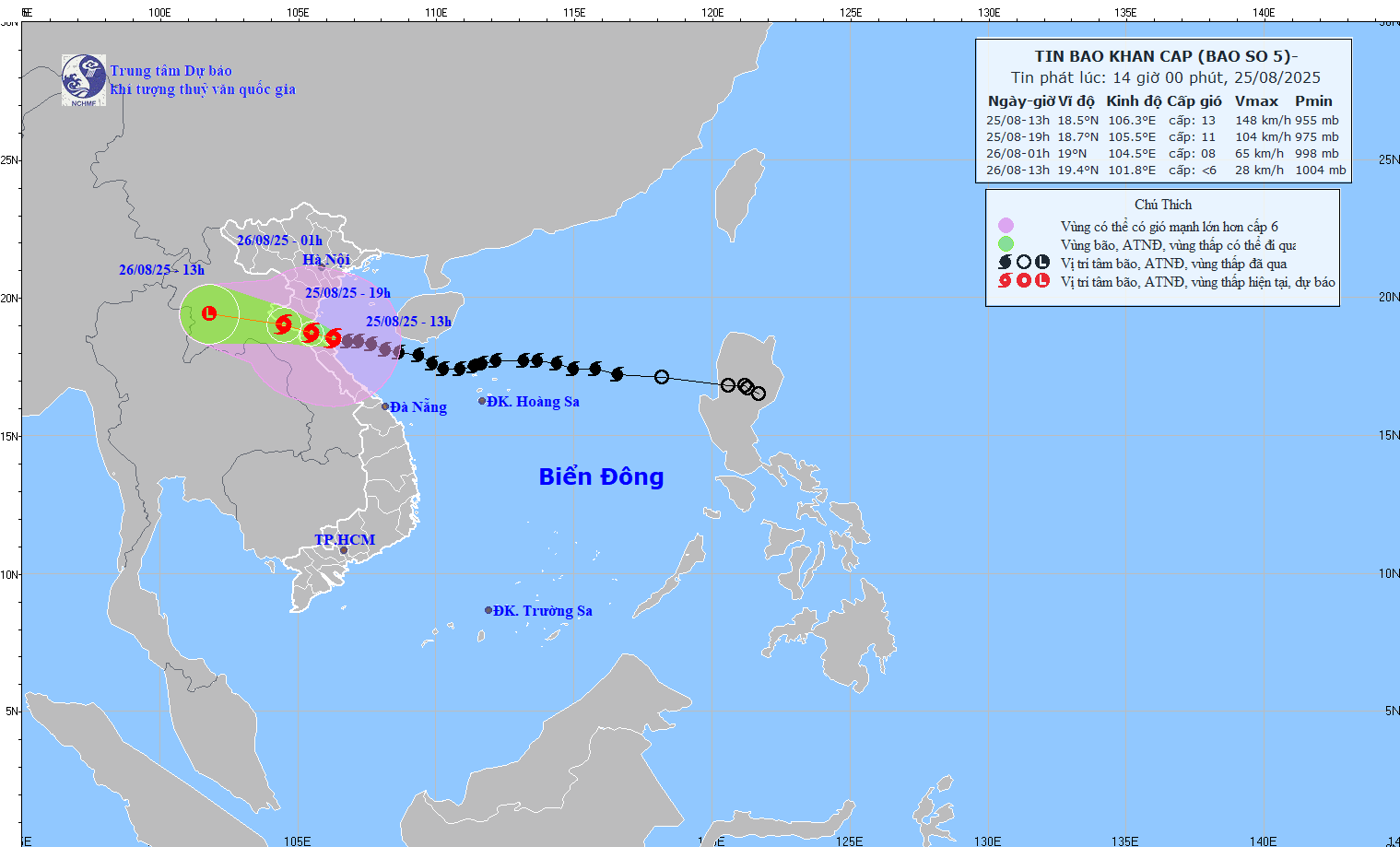
The sea area from Thanh Hoa to Quang Tri (including Hon Ngu island, Con Co special area) has strong winds of level 8-11, the area near the storm's eye has level 12-13, gusts of level across; waves 5.0-4.0m high, the area near the storm's eye has 8.0-10.0m; the sea is very rough.
The northern Gulf of Tonkin (including the special areas of Cat Hai, Co To, Van Don) will have strong winds of level 6-7, gusting to level 9; In the south, the northern area of the Gulf of Tonkin (including the special area of Bach Long Vi) will have strong winds of level 7-8, gusting to level 10; waves 3.0-5.0m high; rough seas.