The latest storm and low pressure information on August 13 from the Philippine Atmospheric, Geophysical and Astronomical Services Administration (PAGASA) said that 4 consecutive low pressure areas are forecast to appear around the East Sea after Typhoon Podul.
According to the bulletin, during the forecast period from August 13 to August 19, while Typhoon Podul made landfall twice in Taiwan (China) on August 13 and mainland China on the morning of August 14, two low pressure areas will appear consecutively around the East Sea.
The first of these is a low pressure near the South China Sea, appearing north of the Philippines with an area of influence extending north. The second low pressure in the forecast period is a low pressure in the East Sea, likely to form between the East Sea and gradually move northwest, towards Vietnam.
PAGASA experts said that both low pressure areas in the forecast period are unlikely to strengthen into storms or tropical depressions.
Right after the two systems, two other depressions are expected to appear in the period from August 20 to August 26. The third low pressure is a low pressure near the East Sea, expected to form within the Philippine Forecast Area (PAR). This low pressure is likely to move westward, make landfall in the Philippines and then enter the East Sea.
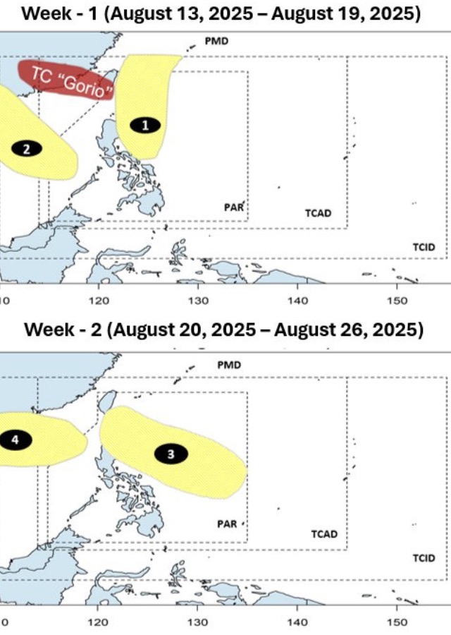
Right after this low pressure near the East Sea is another low pressure appearing in the northern part of the East Sea. The fourth low pressure has a very wide area of influence, likely affecting China and Vietnam.
According to the Philippine State Weather Forecast Agency, from August 2025 to January 2026, 17 storms are forecast to enter or develop in the PAR.
In August alone, 2 to 3 storms are forecast to enter the PAR forecast area. Typhoon Podul is the first typhoon of August. Meanwhile, September is forecast to have 2-4 storms, October is forecast to have 2-4 storms, November is forecast to have 2-3 storms, December is forecast to have 1-2 storms, January is forecast to have 0-1 storms.
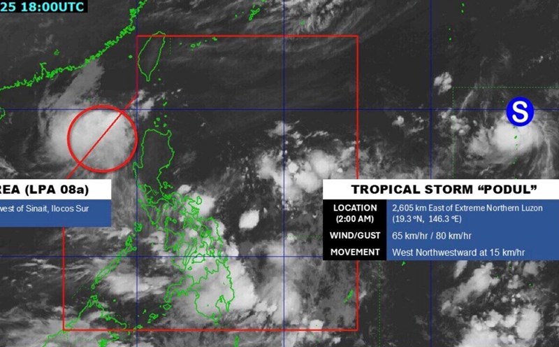
One person missing and at least 112 injured as Typhoon Podul made landfall in southern Taiwan (China) at 1:00 p.m. on August 13, according to an update from the Central Emergency Management Center.
The storm brought strong winds and heavy rain, disrupting daily life as more than 8,000 people had to evacuate from 8 cities and districts including Tainan, Kaohsiung, Binh Dong, Hualien and Taitung. Schools have been closed in some areas as Typhoon Podul approached the island.
The storm has disrupted rail, ferry and air traffic across the region before making landfall.
More than 292,000 households in Taiwan (China) lost power at the same time, with nearly 250,000 homes having been restored and 42,677 houses still without power.
Typhoon Podul made a second landfall along the coast of Zhuangzhou province, Fujian province, eastern China at around 0:30 on August 14. At the time of landfall, Podul was classified as a severe tropical storm, with maximum sustained winds of 108 km/h near the center.