Forecast of 2 consecutive low pressure areas entering the East Sea

Thanh Hà |

2 low pressure areas near the East Sea are forecast to enter the East Sea from now until August 20.

The latest storm and low pressure information on August 6 from the Philippine Atmospheric, Geophysical and Astronomical Services Administration (PAGASA) said that 3 low pressure areas are expected to appear around the East Sea in the first half of August, of which 2 will be active in the East Sea.

Accordingly, during the week from August 6 to August 12, 2 low pressure areas are forecast to appear near the East Sea. The first low pressure area will form in eastern Luzon, within the Philippine Forecast Area (PAR).

This low pressure near the East Sea is likely to strengthen at a moderate level. PAGASA's typhoon forecasters said that this low pressure near the East Sea will pass through Northern Luzon, Philippines and enter the northern part of the East Sea.

2 ap thap co the di vao Bien Dong trong nhung ngay toi. Anh: PAGASA
The two low pressure areas may enter the East Sea in the coming days. Photo: PAGASA

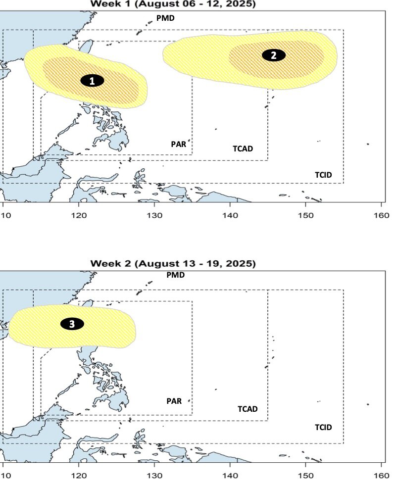
Also during the forecast period, a second low pressure near the East Sea is expected to appear at the northeastern boundary of PAGASA's PMD forecast area. This low pressure is also forecast to have a moderate chance of strengthening into a storm or tropical depression.

A third low pressure is forecast to form during the week of August 13 and August 19. Forecast models show that the depression will form in the northern part of the Philippine Sea and gradually move towards the northern tip of Luzon and enter the East Sea. This low pressure is unlikely to strengthen into a storm or tropical depression during the forecast period.

Bao hoac ap thap gan Philippines trong thang 8 se co 4 huong di chuyen, trong do co the di vao Bien Dong co the anh huong toi Viet Nam. Anh: PAGASA
Storms or depressions near the Philippines in August will have 4 directions of movement, which may enter the East Sea and affect Vietnam. Photo: PAGASA

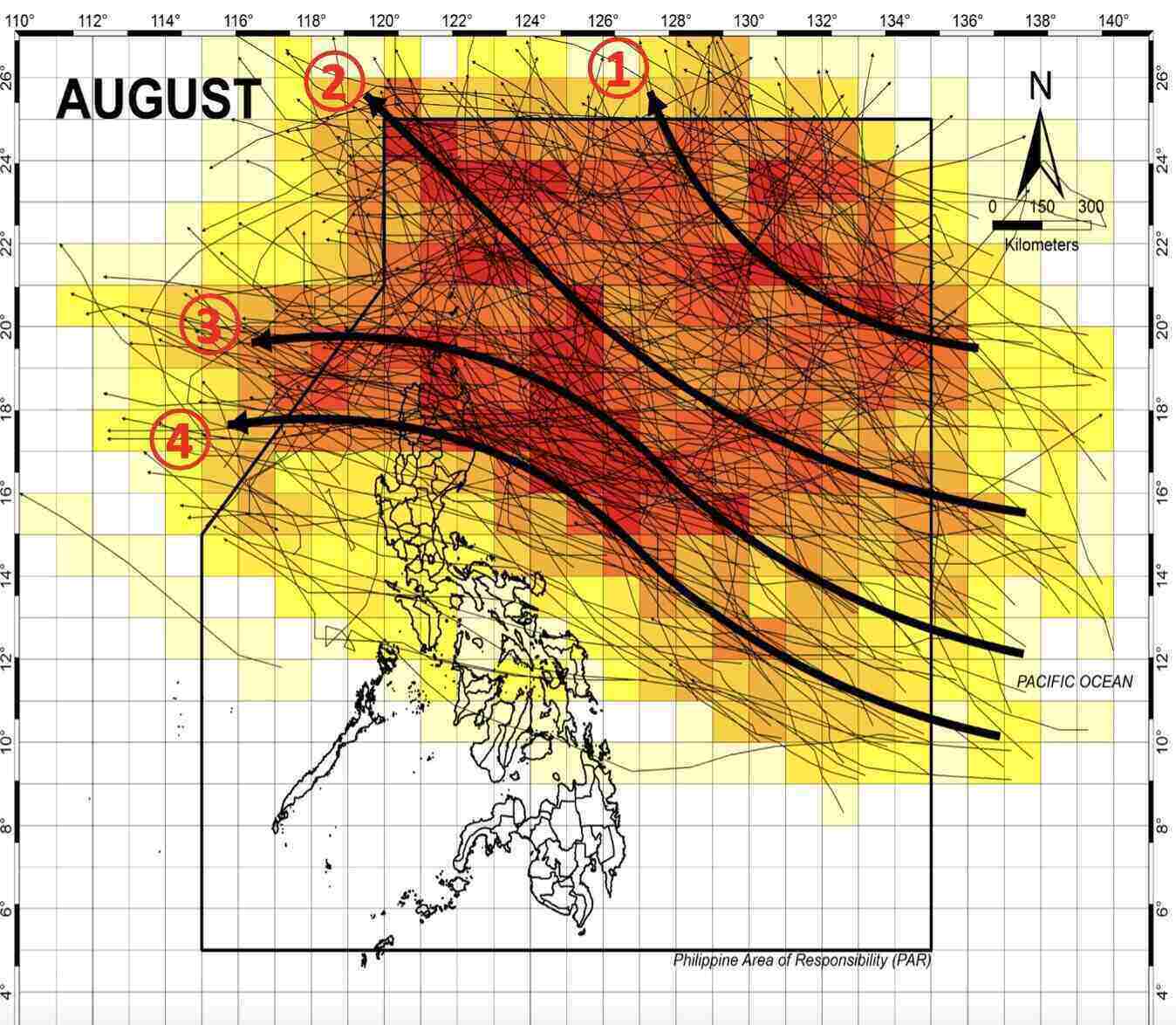
Typically, PAGASA said that storms or depressions near the Philippines in August will have 4 movements. First, the storm or depression enters the north of the PAR but does not make landfall but loops towards Japan but may strengthen the southwest monsoon in the Philippines.

Second, the storm or low pressure pointing northwest of the PAR will not make landfall in the Philippines but only affect the country's weather and then move towards Taiwan (China).

Third, storms or depressions make landfall in the northern islands of the Philippines, then enter the East Sea, towards Hong Kong (China) or Vietnam.

Finally, the storm or depression makes landfall in northern or central Luzon, Philippines, then enters the East Sea, heading straight towards Vietnam.

Vi tri 2 ap thap gan Bien Dong chieu 6.8. Anh: PAGASA
Location of 2 low pressure areas near the East Sea on the afternoon of August 6. Photo: PAGASA

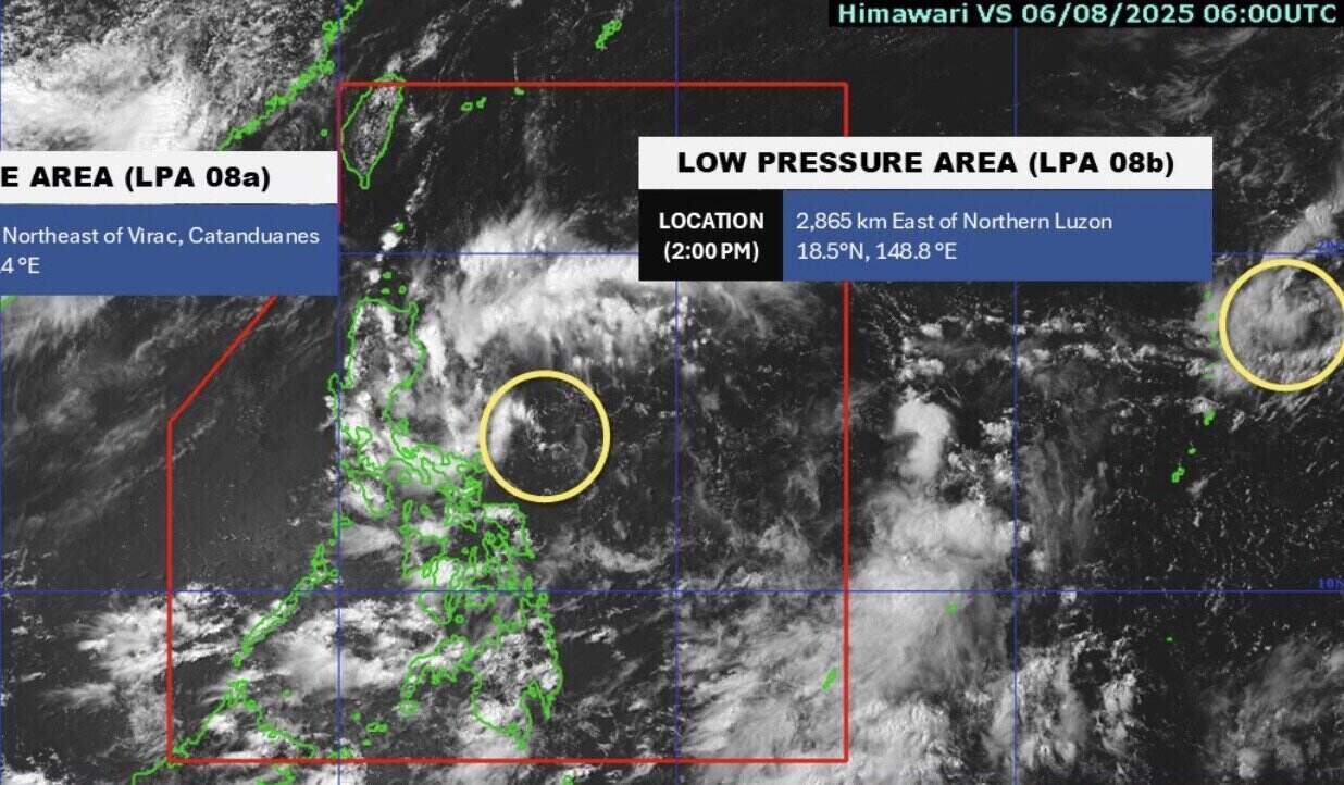
Currently, Philippine weather forecasters are monitoring two low pressure areas near the East Sea. Low pressure 08a is within the PAR forecast area, 240km east of Virac, Catanduanes, Philippines and is unlikely to strengthen into a tropical depression within the next 24 hours.

Low pressure 08b is 2,865 km east of Northern Luzon, Philippines. This low pressure near the East Sea only formed on the morning of August 6 and is unlikely to strengthen into a tropical depression within the next 24 hours.

Thanh Hà
RELATED NEWS

Another low pressure appears near the East Sea

|

A new low pressure near the East Sea appeared on August 6 after a low pressure has been active near the Philippines for the past few days.

Forecast of the most affected area of the low pressure near the East Sea

|

The low pressure near the East Sea is forecast to cause widespread thunderstorms, along with the risk of flash floods and landslides in many areas.

Low pressure near the East Sea forecast to cause first impacts

|

The low pressure near the East Sea is forecast to cause rain in many areas of the Philippines.

Container truck catches fire on My Phuoc - Tan Van road in Ho Chi Minh City

|

HCMC - A container truck caught fire on My Phuoc - Tan Van road. The authorities quickly put out the fire and regulated traffic.

20h News: People complain about the sudden increase in electricity bills in July despite being absent

|

People complain about the sudden increase in electricity bills in July despite being absent; The Ministry of Home Affairs responds to recommendations on the arrangement of concurrent commune accountants...

Early resignation is no longer a strategic move for Ms. Paetongtarn

|

August is considered a turning point in the political fortunes of Ms. Paetongtarn Shinawatra and Mr. Thaksin Shinawatra.

In the next 4 days, many streets in Hanoi will ban vehicles from circulating during certain time frames

|

Hanoi - Some routes will completely ban vehicles from circulating during certain time frames (from August 7 to August 10, 2025).

There are projects of thousands of hectares abandoned for 20 years but the State has not collected anything

|

According to Mr. Le Dinh Thang - Chief Auditor of the State Audit Office, Sector 2, there are projects of thousands of hectares that have been abandoned for 20 years but the State has not collected anything.

Another low pressure appears near the East Sea

Thanh Hà |

A new low pressure near the East Sea appeared on August 6 after a low pressure has been active near the Philippines for the past few days.

Forecast of the most affected area of the low pressure near the East Sea

Khánh Minh |

The low pressure near the East Sea is forecast to cause widespread thunderstorms, along with the risk of flash floods and landslides in many areas.

Low pressure near the East Sea forecast to cause first impacts

Thanh Hà |

The low pressure near the East Sea is forecast to cause rain in many areas of the Philippines.