The latest storm news on the morning of July 5 from the Japan Meteorological Agency confirmed that the tropical depression named Bising in the Philippines has strengthened into a tropical storm with the international name Today.
Today is the latest named storm in the western Pacific basin in 2025 and the second in July, after Mun. The name " Today's storm" was given by the Philippines, and is from Tagalog meaning "experience" or "feel".
The Philippine Atmospheric, Geophysical and Astronomical Services Administration (PAGASA) forecasts that Typhoon Today will cause strong gusts of wind in northern Luzon until July 6 and strengthen the southwest monsoon, affecting the weather in most of Luzon.
Typhoon Today developed three weeks after Tropical Depression Auring, the first named weather system in the Philippines this year, on June 11. Auring made landfall in Taiwan (China) on June 12 but quickly weakened.
The latest storm information from the Taiwan Weather Forecast Agency (China) said that Typhoon Today is moving slowly towards the Taiwan Strait (China) in the east-northeast direction.
The latest typhoon is expected to change direction late on July 5 to the north or northeast and approach Taiwan (China) closest from July 6 to the morning of July 7. The most serious impact of storm today will occur between noon on July 6 and the morning of July 7.
The latest typhoon information from the US Navy's Joint Typhoon Warning Center (JTWC) said that Typhoon Today is 411 km southeast of Hong Kong (China) and has been moving west at a speed of 7 km/h over the past 6 hours.
JTWC forecasters said that today will start moving slowly northward over the next 24 hours as the subtropical low pressure zone in the southeast forms.
In terms of intensity, storm today is expected to rapidly strengthen in the next 24 hours, reaching a maximum intensity of 140 km/h in the next 36 to 48 hours.
In about the next 3 days, Typhoon Today will start gradually moving towards the Chinese coast and interaction with the mainland will begin to weaken the system.
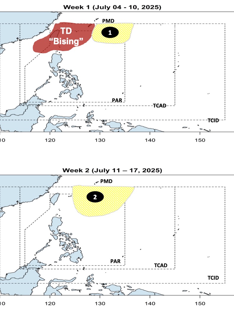
Meanwhile, the latest storm and low pressure forecast on July 5 from PAGASA said that right after storm Today, there will be 2 low pressure areas near the East Sea appearing consecutively.
The bulletin forecasts that today's storm Today will move towards Taiwan and Ryukyu Islands before leaving PAGASA's PMD forecast area during the week of July 5 to July 10.
Also during this forecast period, a low pressure near the East Sea will form in the northeastern part of the Philippine Forecast Area (PAR). The low pressure is located east of Northern Luzon, Philippines and is unlikely to strengthen into a storm during this time.
Philippine weather forecasters said that during the week of July 11 to 17, forecast models will see another low pressure near the East Sea developing in the northeastern boundary of the PAR. The new low pressure is unlikely to strengthen into a storm near the East Sea.