Although it did not make landfall directly, Typhoon Ha Long is forecast to still approach the southern sea of Japan, causing meteorologists to warn: "Ha Long is still young, the path can change at any time".
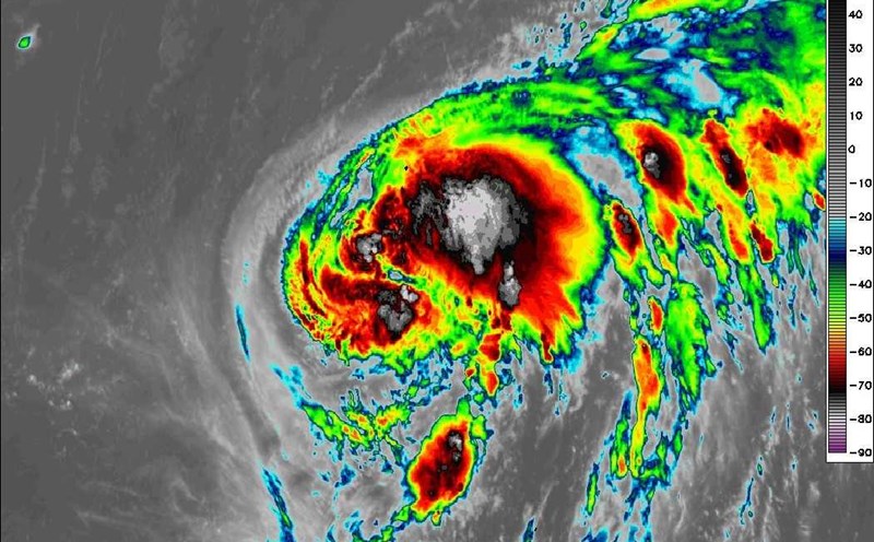
The latest storm information from the Philippine Atmospheric, Geophysical and Astronomical Services Administration (PAGASA) said that at 8:00 a.m. on October 6, the center of storm Ha Long was at about 25.5 degrees north latitude, 114.5 degrees east longitude, 2,075 km east-northeast of the northernmost tip of Luzon (Philippines). Maximum winds near the center of the storm are 100 km/h, gusting to 125 km/h. The storm is moving west-northwest at 10 km/h.
The Joint Typhoon Warning Center (JTWC) forecasts the storm to accelerate and gradually strengthen over the next 48 hours, reaching winds of 210 km/h, gusting to 260 km/h - equivalent to a Category 4 super typhoon on the Saffir-Simpson scale - in the early morning of October 8.
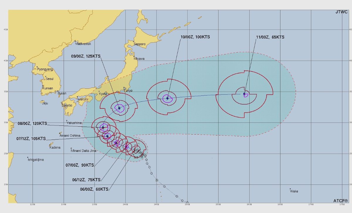
The good news is that according to the latest direction, Typhoon Ha Long will not make landfall directly in Japan. The center of the storm is forecast to move more than 800km northeast of Okinawa Island and will pass about 250km south of Honshu Island this weekend.
Forecast models for GFS and Europe are starting to agree, with the assessment that Ha Long will soon change direction to the east-northeast, moving away from the Japanese archipelago before weakening in the Pacific Ocean.
However, meteorologists warn against being subjective. The JTWC emphasized: Storm Ha Long is still in the early stages of development. The path and intensity of the storm may change rapidly, especially in the next 48 hours".
US military bases in Japan are still maintaining seasonal storm response readiness. People are advised to prepare a backup plan and closely monitor the latest weather forecast from the Japan Meteorological Agency (JMA) and JTWC.
Preparation is never redundant, the JTWC statement stressed. Although Typhoon Ha Long may turn out to sea, a small change is still enough to severely affect Japans weather. The JTWC warned that rough seas, strong gusts of wind and waves up to 10m high could affect fishing vessels, shipping routes and southern Japan.
If it reaches the forecast intensity, Typhoon Ha Long will become the strongest storm in the Northwest Pacific region in October this year, after a series of strong storms appeared in the East Sea and Northwest Pacific from the end of September.
The name Ha Long proposed by Vietnam in the list of international storms by the World Meteorological Organization (WMO), taken from the natural wonder of Ha Long Bay.
Typhoon Ha Long is unlikely to enter the East Sea and will not directly impact the mainland of Vietnam. In addition, on the morning of October 6, another low pressure area with the number 95W was formed, tending to move westward, this low pressure area is also forecast to have little chance of entering the East Sea area.
However, the tropical convergence zone operating in the Northwest Pacific will continuously produce low-lying cyclones and tropical cyclones from now until the end of December, especially after the time when storm No. 11 dissipates.
It is forecasted that in the second half of October, there is a low possibility of tornadoes operating in the East Sea area, combined with the northeast monsoon and disturbances in the high-altitude easterly wind zone, which will cause heavy rain in heavy rain in the Central Vietnam area until the first half of December.