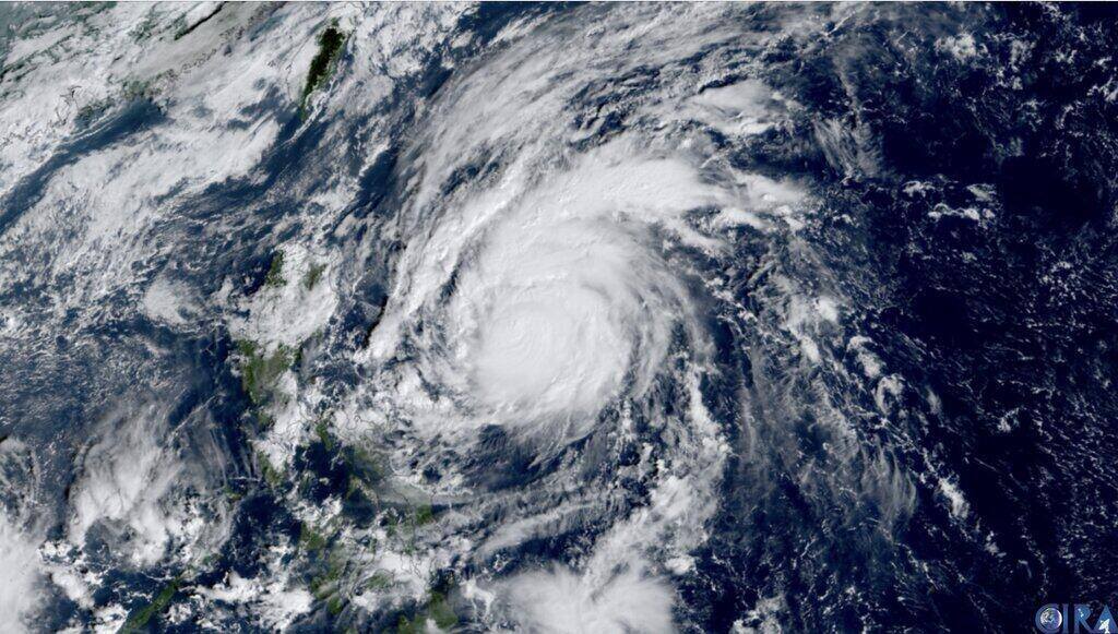
The latest storm and depression forecast from the Philippine weather agency PAGASA on November 6 said that during the week from November 6-12, Typhoon Yinxing (local name Marce) is expected to approach Northern Luzon, Philippines and is likely to leave the Philippines' PAR forecast area and enter the East Sea during the forecast period.
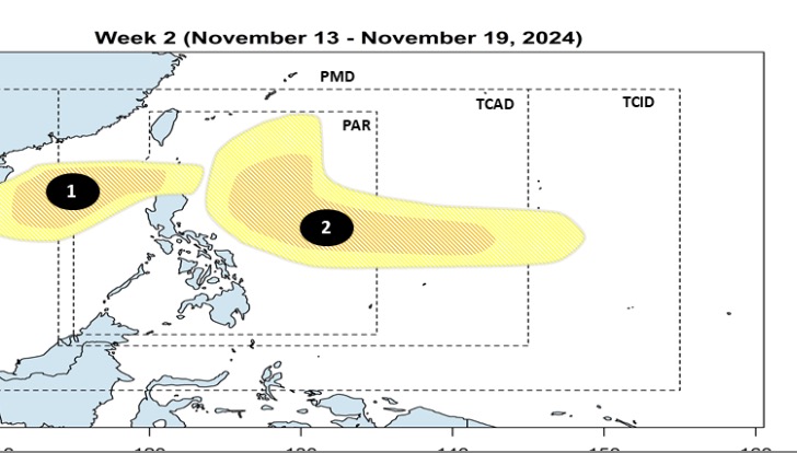
Immediately following Typhoon Yinxing, PAGASA forecast models indicate that two depressions are likely to form. Two new depressions near the Philippines are likely to form at the eastern boundary of PAGASA’s PMD forecast area. The two new depressions are expected to strengthen into low to moderate storms.

PAGASA’s forecast bulletin stated that the first low pressure area that forms as soon as Typhoon Yinxing enters the East Sea will appear in PAGASA’s TCAD forecast area. This low pressure area is expected to enter the PAR area of the Philippines between November 6 and 12.
Meanwhile, a second low pressure area is likely to form east of PAGASA's TCID forecast area.
PAGASA forecasts that two new low pressure systems that appeared after Typhoon Yinxing will continue to move west and strengthen during the week of November 13-19.
Storm and low pressure forecast models show that two low pressure systems near the Philippines are likely to pass north of the PAR forecast area, where conditions are favorable for the two systems to strengthen into storms.
The first low pressure is expected to pass through the Northern Luzon area, Philippines and enter the East Sea, becoming storm number 8 in the East Sea.
The second low pressure near the Philippines is forecast to approach eastern Luzon before turning towards Japan.
Overall, during the forecast period, tropical depressions and new storms are likely to continuously affect the weather in the Philippines.

According to the latest typhoon forecast from Windy.com, Yinxing is the third major typhoon to threaten the Philippines in less than a month, following Typhoon Trami and Super Typhoon Kong-rey. Typhoon Yinxing is approaching the northeastern Philippines and is expected to make landfall in Cagayan province between the evening of November 7 and the morning of November 8. The storm is currently packing winds of 120 km/h and is located about 590 km east of Baler in Aurora Province, Philippines.
Meanwhile, PAGASA said that at 4 p.m. on November 6, local time, Typhoon Yinxing was 295 kilometers east of Aparri, Cagayan. The storm had maximum winds of 150 kilometers per hour near its center, gusts of up to 185 kilometers per hour, and was moving slowly westward.
According to the latest typhoon forecast from the Hong Kong Observatory (China), Typhoon Yinxing is expected to be 800 km away from Hong Kong (China) on November 7 and may move closer from the night of November 7 to the morning of November 8. Due to the influence of the northeast monsoon, the direction and intensity of Typhoon Yinxing after entering the East Sea are still uncertain.
Yinxing, which means ginkgo in Chinese, is the storm's proposed name in China.


