Forecast of storms and low pressure in August

Khánh Minh |

The 2025 typhoon season is entering an explosive period with the simultaneous appearance of up to 10 typhoon/low pressure systems, in which super typhoons may appear earlier than expected.

On July 29, the US National Hurricane Center (NHC) is monitoring up to five tropical waves in the Atlantic and five systems under development in the Pacific, including a storm Iona that is approaching Category 4, with gusts of up to 200 km/h, not excluding the strengthening into a super typhoon.

The tropical environment will become significantly more favorable for Atlantic hurricane activity in the coming weeks, said Colorado State University forecaster Phil Klotzbach. The period from mid-August to mid-October is usually the time when the most super typhoons appear in the year.

5 tropical waves accelerating in the Atlantic

The latest storm news from the NHC at 2:00 p.m. on July 29 (US time) said that there are up to 5 tropical waves accelerating in the Atlantic.

Tropical Storm No. 1: In the eastern Atlantic (terrainline 22W), moving west at a speed of 17-27 km/h.

Wave No. 2: In the mid- Atlantic ( corridor 40W), the speed is slower at about 10 km/h.

Waves 3-5: Both located in the Caribbean Sea from longitude 68W to 87W, carrying showers and thunderstorms, are likely to form a tropical depression in the coming days.

So far, three named storms have been named for the 2025 Atlantic hurricane season:

Andrea (24.6): 4 days earlier than average

Barry (29.6): 18 days earlier

Chantal (5.7): Nearly a month earlier

The next storm, named Dexter, is expected to appear before August 15, earlier than the annual average.

Pacific Front: Iona and Keli explode together

On the Pacific side, the NHC is monitoring five dangerous weather systems.

Trung tam Bao quoc gia My dang theo doi 5 he thong o Thai Binh Duong, bao gom ca con bao lon Iona, vao luc 8h ngay 29.7.2025 (gio dia phuong). Anh: NOAA
The US National Hurricane Center is monitoring five systems in the Pacific Ocean, including major storm Iona, at 8:00 a.m. on July 29, 2025 (local time). Photo: NOAA

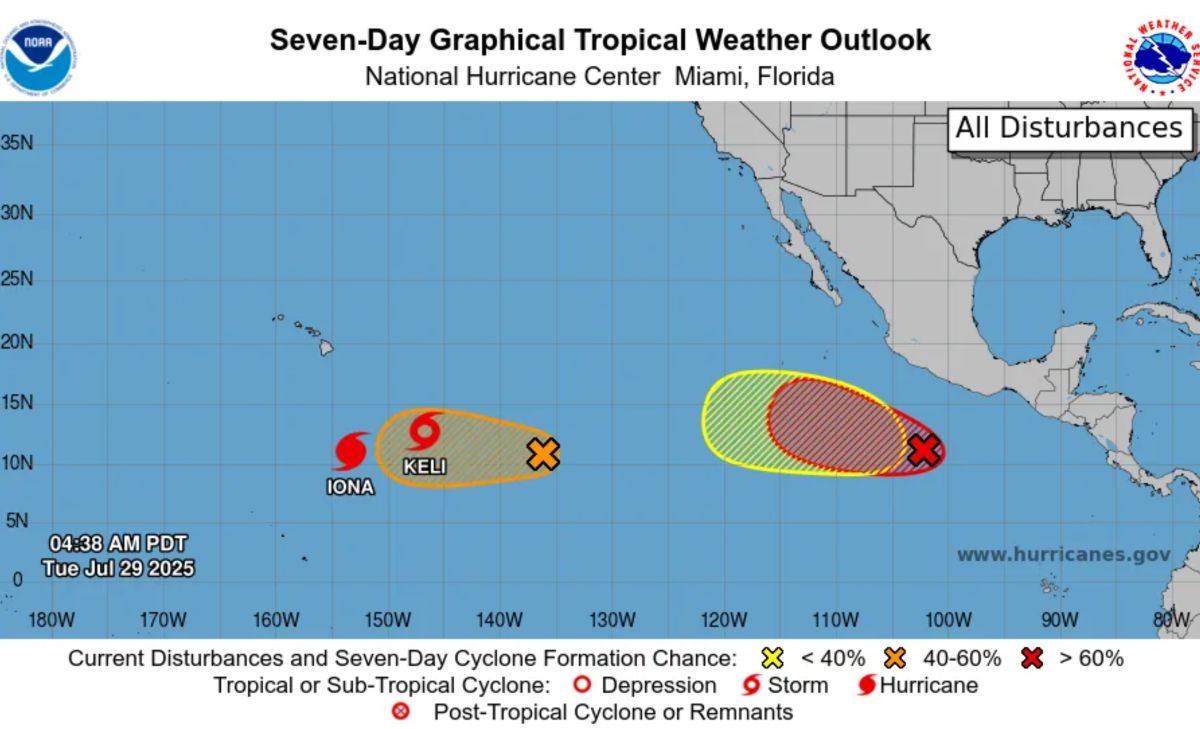
January has become a Category 3 storm, with sustained winds of 205 km/h, just a short distance from Category 4, not excluding the strengthening into a super typhoon. The storm is about 1,180 km south of Hawaii.

Typhoon Keli is a tropical storm with winds of 65 km/h, showing no signs of significant strengthening.

EP98 and EP99 are both low pressure areas with the risk of becoming storms in the next 48 hours.

A new low pressure area is expected to form later this week, south of Mexico.

US officials stressed that people in states along the Atlantic and Pacific need to start preparing early in August. This year, the state of Florida (USA) will permanently exempt taxes on storm prevention and control items starting from August 1.

If the typhoon forecasts come true, August and September will be a real typhoon in both oceans.

In the East Sea, according to the Vietnam National Center for Hydro-Meteorological Forecasting, from now until the end of the year, the East Sea may have 8-11 storms, of which 3-5 will directly affect the mainland of Vietnam.

From August to October is the peak of storms and floods, with about 6-8 storms and tropical depressions expected to operate in the East Sea, of which 2-3 can directly affect the mainland of Vietnam. In November and December, there may be 2-3 more storms and tropical depressions, of which 1-2 will make landfall.

Khánh Minh
RELATED NEWS

Three fierce storms rise, storms Keli rapidly strengthen

|

Three consecutive tropical storms formed and rapidly intensified, causing waves in the Pacific Ocean.

Forecast of storms and low pressure in the storm center near the East Sea

|

The latest storm news shows that there are currently 3 tropical cyclones active with a new pressure that is likely to develop in the storm center near the East Sea.

This year's storm forecast is stronger and more frequent

|

According to the latest storm forecasts, this year's storm season sees the frequency of landfall storms increasing in intensity.

Hanoi Party Secretary requests drastic removal of urban bottlenecks

|

Hanoi - Hanoi Party Secretary Nguyen Duy Ngoc requests the Construction sector to thoroughly handle congestion, flooding, and urban bottlenecks.

Live football U23 Korea vs U23 Australia in the U23 Asian Cup quarter-finals

|

Live broadcast of the match between U23 Korea and U23 Australia in the quarter-finals of the 2026 AFC U23 Championship, taking place at 10:30 PM today (January 17).

Live football Man United vs Man City in the Premier League

|

Live football match Man United - Man City in round 22 of the Premier League, taking place at 7:30 PM on January 17 (Vietnam time).

15-year traffic jam at the eastern gateway of Ho Chi Minh City is about to be removed

|

Ho Chi Minh City - The bottleneck on National Highway 1, the section of the new Mien Dong Bus Station - Tan Van, is expected to be expanded from the end of 2026, helping to eliminate traffic jams at the eastern gateway.

Excavation of an ancient tomb nearly 2,000 years old in Quang Ninh

|

Quang Ninh - During the excavation of an ancient tomb nearly 2,000 years old in Vang Danh, Quang Ninh province, many important artifacts were discovered.

Three fierce storms rise, storms Keli rapidly strengthen

Khánh Minh |

Three consecutive tropical storms formed and rapidly intensified, causing waves in the Pacific Ocean.

Forecast of storms and low pressure in the storm center near the East Sea

Khánh Minh |

The latest storm news shows that there are currently 3 tropical cyclones active with a new pressure that is likely to develop in the storm center near the East Sea.

This year's storm forecast is stronger and more frequent

Song Minh |

According to the latest storm forecasts, this year's storm season sees the frequency of landfall storms increasing in intensity.