Forecast of the time when a new low pressure near the East Sea will form

Thanh Hà |

The new low pressure near the East Sea is forecast to appear during the week of May 16 to 22.

The latest storm and low pressure information from the Philippine Atmospheric, Geophysical and Astronomical Services Administration (PAGASA) on May 9 said that during the week from May 9 to May 15, no low pressure or storm is forecast to form within the Philippine Forecast Area (PAR).

Forecast models show little chance of a low pressure or storm forming during this period in the larger PMD forecast area.

However, the low pressure near the East Sea is expected to form between May 16 and May 22.

Philippine typhoon forecasters say a new low pressure is likely to form within the PAR before approaching Eastern Visayas and Eastern Luzon.

Although it is forecast to have a large area of impact, this low pressure near the East Sea is unlikely to strengthen into a storm during the forecast period.

PAGASA's May 7 storm forecast said that a new low pressure area has formed and is likely to enter the East Sea during the week of May 14 to May 20. At that time, this low pressure near the East Sea was forecast to appear at the eastern boundary of the Philippine PAR forecast area and was unlikely to strengthen into a storm.

However, throughout the forecast period, this low pressure will move northwest, near Visayas and Southern Luzon, with the possibility of passing through the Philippines and entering the East Sea.

Duong di cua bao thang 5 gan Bien Dong. Anh: PAGASA
The path of the May storm near the East Sea. Photo: PAGASA

One to two storms are forecast to form in the PAR region in May. Experts predict the likelihood of typhoons will increase as the Philippines is entering the typhoon season. The first storm of this year's hurricane season will be named Auring, followed by Bising.

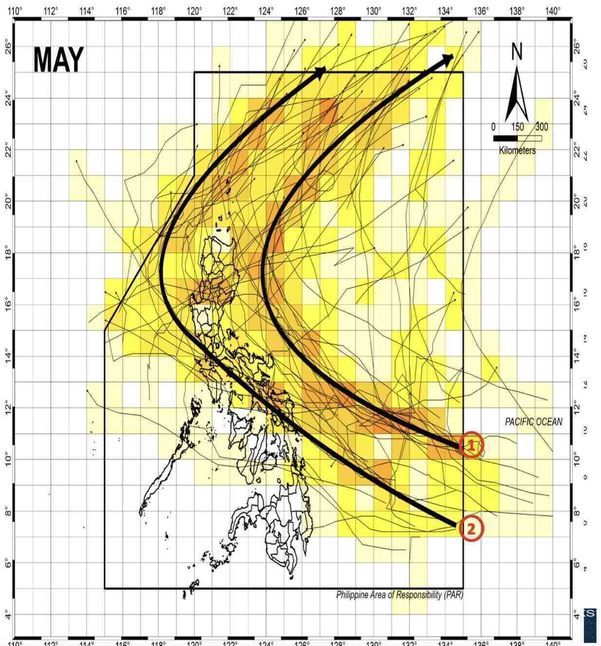
Typhoons in May that form in the Philippine forecast area typically have two movements, PAGASA said.

According to Pagasa's forecast models, two common lines of the May storm include: Storms formed in the Western Pacific basin, going into the Par forecast area and then around the East and not landing in the Philippines; The storm formed in the Western Pacific basin into the Par forecasting area, the central Philippines landing then circled to the northeast before leaving PAR.

An average of 20 typhoons occur in the Philippines each year, with 8-9 of them likely to make landfall. Similar to May, forecasters in the Philippines predict that there could be one to two storms forming or entering the PAR forecast area in June. From July, August and September 2025, it is expected that there will be 2 to 3 storms/month.

Thanh Hà
RELATED NEWS

Forecast of when storm No. 1 will appear in this year's storm season

|

The first storm of the 2025 Atlantic hurricane season could form before June.

Forecast of more low pressure likely to enter the East Sea

|

The low pressure near the East Sea will have the first effects on the weather in the Philippines and a new low pressure is forecast to enter the East Sea in the coming weeks.

2 consecutive low pressure areas appear around the East Sea

|

The low pressure near the East Sea appeared in the context of the low pressure in the East Sea that has been active for the past few days.

20h News: The highest personal income tax rate is expected to be 35%

|

20h News on November 4: The highest personal income tax rate is expected to be 35%; Son Hai Group speaks out after the information about the project inspection conclusion;...

Penalty for the case of a brother-in-law who caused a series of accidents in Thai Nguyen

|

Thai Nguyen - Without steering, a young man still stood up to take over his brother-in-law after he caused an accident and was fined 2.5 million VND.

Tea room fire at the foot of An Duong bridge, Hai Phong

|

Hai Phong - On November 4, there were 2 fires in houses in Le Chan ward and An Hai ward in the city.

Continued landslides in Ha Tinh while workers are crossing the route, 2 people injured

|

Ha Tinh - A worker driving a excavator and a truck driver while clearing rocks and soil to clear the route continued to slide, causing both the vehicle and the engine to collapse, injuring 2 people.

HCMC adjusts roadmap to expand central road to 4 lanes, clearing 115 households

|

Ho Chi Minh City has adjusted the roadway of Tran Binh Trong Street from 5m to 17m, equivalent to 4 lanes. The project plans to clear 115 households in the park to have a site for implementation.

Forecast of when storm No. 1 will appear in this year's storm season

Thanh Hà |

The first storm of the 2025 Atlantic hurricane season could form before June.

Forecast of more low pressure likely to enter the East Sea

Thanh Hà |

The low pressure near the East Sea will have the first effects on the weather in the Philippines and a new low pressure is forecast to enter the East Sea in the coming weeks.

2 consecutive low pressure areas appear around the East Sea

Thanh Hà |

The low pressure near the East Sea appeared in the context of the low pressure in the East Sea that has been active for the past few days.