After just one day of forming off the coast of western Mexico, Barbara - a calm tropical depression - quickly transformed into the first hurricane of this year's East Pacific hurricane season, according to the US National Hurricane Center (NHC).
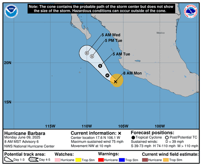
The latest NHC hurricane report says that at 8:50 a.m. on June 10, the center of Hurricane No. 1 Barbara was about 250 km southwest of the port city of Manzanillo, with maximum sustained winds of 120 km/h (equivalent to level 12), enough to be classified as a Category 1 storm on the Saffir-Simpson scale.
Although no coastal warnings have been issued, the NHC stressed that areas of Mexico's southwestern coast - including Colima, Guerrero, Michoacan and Jalisco states - will face dangerous high waves, strong offshore currents and gusts in the coming hours.
In addition, heavy rains can cause localized flooding, especially in low-lying areas or near rivers and streams.
NHC forecasts show that Barbara may have reached near its peak intensity. In the next 6 to 12 hours, the storm may maintain its strength before weakening gradually from June 11.
However, it is not ruled out that Barbara will have another short acceleration before weakening, as the current environmental conditions around it are still favorable - high sea surface temperatures and few high winds.
While Barbara rocked western Mexico, another storm, Cosme, is also gradually strengthening and is forecast to approach typhoon level on June 10. However, Cosme is expected to change direction to the northeast and move faster from June 10-11.
The hurricane season in the eastern Pacific begins on May 15, while the Atlantic has only entered the hurricane season since June 1. However, according to the latest hurricane forecast from the US National Oceanic and Atmospheric Administration (NOAA), this year's Atlantic hurricane season is likely to be above average, with 13-19 named storms, of which 6-10 could strengthen into hurricanes, and 3-5 become super typhoons.
Typhoon No. 1 Barbara could be just the first "fireworks" of a turbulent typhoon season in the eastern Pacific. The coastal community of Mexico and countries along the Pacific need to be especially vigilant and closely monitor weather forecasts in the coming days.
Meanwhile, in the East Sea, on June 10, the Vietnam National Center for Hydro-Meteorological Forecasting said that a tropical depression is likely to strengthen into the No. 1 storm in the East Sea in the next 48 hours.
At 7:00 a.m. on June 11, the tropical depression was at about 15.6 degrees north latitude and 114.3 degrees east longitude, about 240km east-southeast of Hoang Sa archipelago. The strongest wind near the center of the tropical depression is level 7, gusting to level 9.
It is forecasted that in the next 48 hours, the tropical depression is likely to strengthen into a storm and move west-northwest at a speed of 10 - 15km/h.
At 7:00 a.m. on June 12, the center of the storm was located in the Hoang Sa archipelago, at about 16.4 degrees north latitude and 111.6 degrees east longitude. Strong winds of level 8 - 9, gusting to level 11.


