According to the National Center for Hydro-Meteorological Forecasting, a low pressure area is currently active in the eastern sea of the North East Sea.
On the evening of September 5, the low pressure area over the Northeast of the East Sea has strengthened into a tropical depression.
On the morning of September 6, the center of the tropical depression was at about 17.7°N - 117.6°E, in the northeastern sea of the East Sea. Maximum wind speed is level 7 (5061 km/h), gusting to level 9. Moving northwest, speed 1015 km/h.
Forecast of the development of the tropical depression/storm (2448 hours in the next 24 hours): At 7:00 a.m. on September 7, the tropical depression will move northwest at a speed of 1015 km/h, likely to strengthen into a storm.
The forecast location is at 19.4°N - 115.1°E, about 430 km northeast of the Hoang Sa archipelago. Strong wind level 8, gust level 10.
Dangerous area: latitude 16.021.0°N; longitude 113.5119,0°E. Natural disaster risk level: level 3, northeastern sea area of the East Sea.
At 7:00 a.m. on September 8, the storm continued to move northwest, at a speed of about 15 km/h and strengthened.
Location at 21.8°N - 112.0°E, in the coastal area of Guangdong province (China). Strong wind level 9, gust level 11.
Dangerous area: north of latitude 18.0°N; longitude 110.0117.0°E. Natural disaster risk level: level 3, the northern sea area of the East Sea.
Warning of storm developments (48-72 next hours).
In the next 4872 hours, the storm will move in a West-Northwest direction, at a speed of about 15 km/h.
Forecast of the impact of tropical depression/storm as follows:
At sea: The northeastern sea area of the East Sea has strong winds of level 6, then increased to level 78, gusting to level 10; waves 2.04.0 m high, rough seas.
Ships operating in the dangerous area are likely to be affected by thunderstorms, whirlwinds, strong winds and large waves.
To proactively respond to the tropical depression, the Minister of Agriculture and Environment issued Official Dispatch No. 6408/CD-BNNMT dated September 5, 2025, requesting ministries, branches and People's Committees of coastal provinces and cities from Quang Ninh to Dak Lak as follows:
Closely monitor the developments of the tropical depression; strictly manage vehicles going out to sea; organize counting, notify owners of vehicles, captains of ships and boats operating at sea of the location, direction of movement and developments of the tropical depression to proactively avoid, escape or not move into dangerous areas.
Prepare forces and means for rescue when required.
Ministries and branches, according to their functions, state management tasks and assigned tasks, proactively direct and coordinate with localities to respond to tropical depressions.
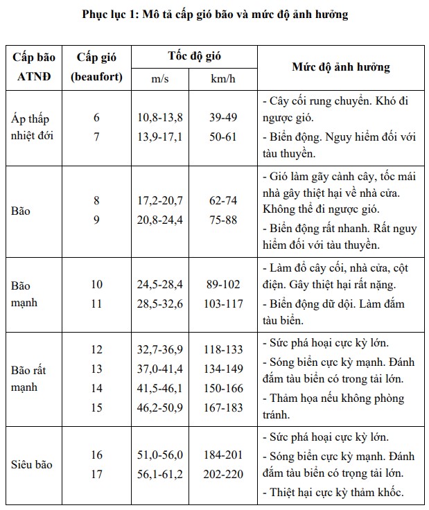
described tropical depression/storm wind supply and impact level: