On the afternoon of June 11, the Ministry of Agriculture and Environment held a meeting to respond to storm No. 1 and heavy rain.
At the meeting, Deputy Minister of Agriculture and Environment Nguyen Hoang Hiep said that this year, storm No. 1 will form right in the East Sea instead of the usual storm at the beginning of the season forming from the sea outside. The notable impact of the storm is causing heavy rain in the Central region and the Northern Central Highlands.
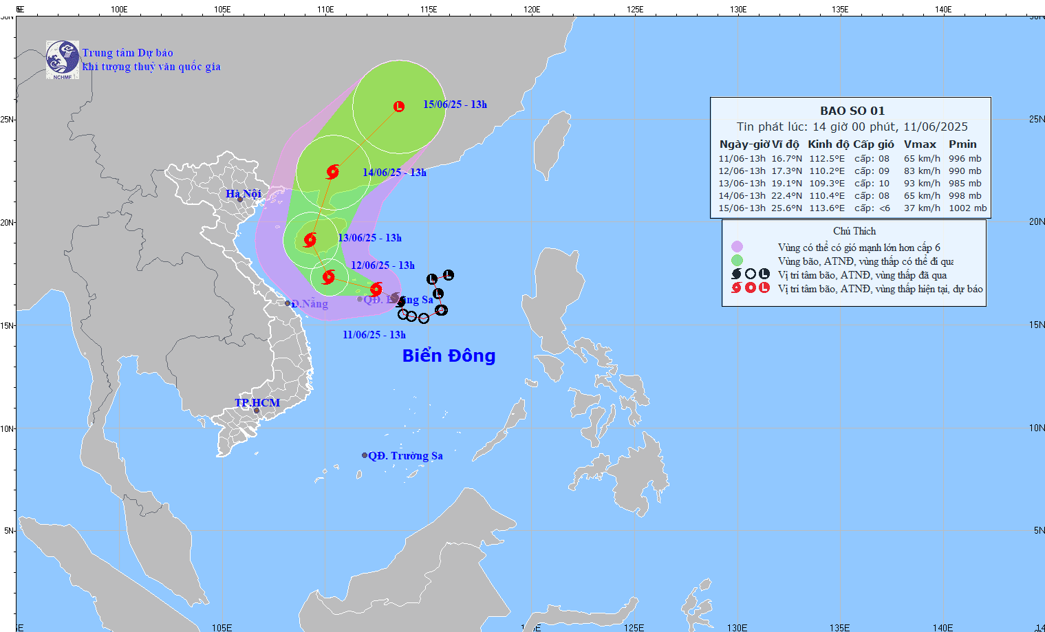
Mr. Mai Van Khiem - Director of the National Center for Hydro-Meteorological Forecasting said that at 1:00 p.m. this afternoon, June 11, the center of the storm was located east of Hoang Sa archipelago, with the strongest wind near the center of the storm at level 8, gusting to level 10.

It is forecasted that this evening, the storm will move west-northwest at a speed of about 10km/h. From tonight and tomorrow, the storm is likely to move northwest and north towards Hainan Island (China).
In terms of intensity, strong winds of level 8 are forecast to continue today. Tomorrow, the storm is likely to strengthen to level 9 and on June 13 it may strengthen to level 10.
According to Mr. Khiem, international forecasts all have the same assessment that the storm will move in an arcing direction, towards Hainan Island, then enter mainland China.
In terms of intensity, most current forecast options state that the strongest storm intensity is level 10, gusting to level 12.
"Up to now, storm No. 1 has been quite stable and there are no signs of suddenly increasing to a very strong storm level" - Mr. Khiem said.
Regarding the impact of storm No. 1 at sea, the western part of the northern East Sea (including the sea area of Hoang Sa archipelago) has strong winds of level 7-8, the area near the storm's eye has level 9 - 10, gusts of level 13, waves 3 - 5m high, the area near the storm's eye has 4.0 - 6.0m, the sea is very rough.
From the night of June 11, the offshore waters from Quang Tri to Quang Ngai will have winds gradually increasing to level 6-7, near the storm center level 8 - 9, gusts of level 11, waves 3 - 5m high, very rough seas.
From June 12, the sea area east of the Gulf of Tonkin will have winds gradually increasing to level 6-7, near the storm center level 8, gusts of level 10, waves 2 - 4m high, rough seas.
On land, due to the influence of storm No. 1, from the afternoon of June 11 to June 13, in the Central Central region, there will be heavy to very heavy rain with common rainfall from 100 - 300mm, some places over 450mm; the northern Central Highlands will have moderate rain, heavy rain and thunderstorms, locally very heavy rain with common rainfall from 70 - 150mm, some places over 200mm.
Regarding floods, the water level of the Central and Central Highlands rivers is currently low. It is forecasted that from the night of June 11 to 14, rivers from Quang Binh to Quang Ngai are likely to experience a flood with flood peaks at alert level 1 and above alert level 1.
According to the report of the Border Guard Command, 53,792 vehicles/223,054 people have been counted and instructed to know the developments and direction of the storm; of which 160 ships/752 people are operating in the North East Sea (including Hoang Sa archipelago) (122 ships/214 people; Quang Ngai 75 ships/378 people; Binh Dinh 33 ships/160 people). Vehicles in the affected area have received warning information and are moving around the bypass.
According to the report of the Department of Fisheries and Fisheries Control, the total aquaculture area in coastal provinces from Quang Ninh to Khanh Hoa is 192,548 hectares (73,117 hectares of brackish water shrimp farming, 26,047 hectares of tidewater molluscs farming, 95,143 hectares of freshwater aquaculture); 272,367 cages; 3,848 aquaculture cages at risk of being affected by storms and floods.