According to the National Center for Hydro-Meteorological Forecasting, today (October 31), the area from Nghe An to Quang Tri will have moderate rain, heavy rain, locally very heavy rain and thunderstorms. Rainfall from 7am to 3pm on October 31 was locally recorded at monitoring stations over 140mm such as Huong Lam station (Ha Tinh) 169.2mm, Truong Xuan station (Quang Tri) 143.3mm.
Ha Tinh to Da Nang have rain in some places over 700mm
The area from Ha Tinh to Da Nang city from the evening of October 31 to November 2 is forecast to have heavy to very heavy rain with common rainfall of 200 - 400mm, locally over 700mm.
The southern areas of Nghe An and Quang Ngai will have heavy rain with common rainfall of 100 - 200mm, locally very heavy rain over 300mm. Warning of the risk of heavy rain with rainfall greater than 150mm in 3 hours.
In the area from Gia Lai to Lam Dong and the South in the evening and night of October 31, there will be scattered showers and thunderstorms with rainfall of 15 - 30mm, locally heavy rain over 70mm. During thunderstorms, there is a possibility of tornadoes, lightning, hail and strong gusts of wind. Warning of the risk of heavy rain with rainfall greater than 70mm in 3 hours.
On the night of November 2 and November 3, the area from South Nghe An to Quang Ngai will have heavy to very heavy rain with common rainfall of 100 - 200mm, locally over 350mm. Heavy rain in the Central region is likely to last until around the night of November 4.
The meteorological agency warns of natural disaster risk level due to heavy rain, tornadoes, lightning, hail: level 1; in the area from Ha Tinh to Da Nang city, level 2.
New flood appears on rivers from Nghe An to Ha Tinh
Regarding the hydrological situation, currently, floods on rivers from Hue city to Da Nang city are receding, while floods on Huong river (Hue city) are fluctuating above alert level 2.
The water level at 1:00 p.m. on October 31 on the Bo River at Phuoc station was 3.11 m, 0.11 m higher than alert level 2; on the Huong River at Kim Long station was 2.31 m, 0.31 m higher than alert level 2; on the Vu Gia River at Ai Nghia station was 7.97 m, 0.03 m lower than alert level 2; and on the Thu Bon River at Cau Lau station was 3.06 m, 0.06 m higher than alert level 2.
In the next 24 hours, floods on the Huong River are forecast to continue to fluctuate above alert level 2; floods on the Bo River will drop below alert level 2; while floods on the Vu Gia and Thu Bon rivers will decrease to alert level 1 and above alert level 1.
From now (October 31) to November 5, there is a possibility of a new flood on rivers from Nghe An to Ha Tinh; at the same time, floods on rivers from Quang Tri to Da Nang city are likely to rise again.
During this flood, the peak flood level in the upper reaches of Ca River (Nghe An) is likely to rise above alert level 1; Ngan Sau, Ngan Pho rivers (Ha Tinh), Gianh rivers, Kien Giang rivers, Thach Han rivers (Quang Tri) will rise to alert level 2 - alert level 3, some rivers will exceed alert level 3; downstream of La River (Ha Tinh) will rise to alert level 1 - alert level 2; rivers in Hue city and Da Nang city will be at level from below alert level 2 to above alert level 2.
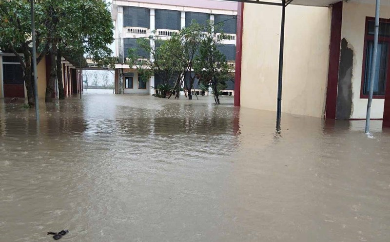
The situation of deep and widespread flooding in Da Nang city is gradually decreasing; flooding in Hue city will also continue to decrease rapidly in the next 1-2 days. However, there is still a risk of flooding in low-lying areas along rivers, urban areas and residential areas concentrated in provinces from Nghe An to Quang Tri.
In addition, there is a high risk of flash floods on rivers and streams and landslides on steep slopes in provinces and cities from Nghe An to Da Nang. Real-time warning information for areas at risk of flash floods and landslides is provided online on the website of the Department of Hydrometeorology at: https://luquetsatlo.nchmf.gov.vn and in a separate bulletin on flash flood and landslide warnings.
The warning level of natural disaster risk due to floods is level 2.
Floods on rivers and flooding in low-lying areas can affect many activities such as waterway transportation, aquaculture, agricultural production, people's lives and other socio-economic activities.
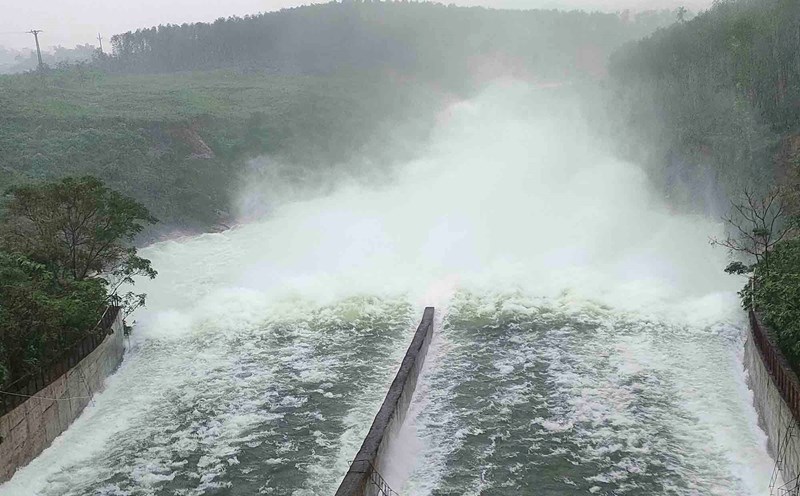
Forecast and warning information is calculated based on the regulated operation scenario of upstream reservoirs. The Hydrometeorological Agency will update bulletins when there are changes in the discharge flow of reservoirs