Latest storm news

Storm No. 1 strengthens and approaches Quang Ninh, causing heavier rain from this afternoon
|
Storm No. 1 has strengthened to level 9, gusting to level 11, heading towards northern Quang Ninh. Strong winds and heavy rain in the Northeast region have also increased from this afternoon.

Hanoi weather forecast for heavy rain due to storm No. 1, in some places over 100mm
|
Due to the impact of storm No. 1, from this afternoon (July 4th) to the afternoon of July 5th, Hanoi weather forecast has moderate to heavy rain, with very heavy rain in some places over 100mm.

Forecast of heavy rain in provinces and cities in the next 2 days due to storm No. 1, in some places over 500mm
|
Due to the impact of storm No. 1, from the morning of July 4 to the end of July 5, the Northeast region and Thanh Hoa will have heavy to very heavy rain, with some places over 500mm.

Forecast of 4 provinces and cities with the heaviest rain due to storm No. 1, with some places over 500mm
|
Storm No. 1 Maysak caused heavy rain in the Northeast, with a focus on Quang Ninh, Hai Phong, Lang Son and Bac Ninh, locally over 500mm.

Storm No. 1 approaches the mainland of Quang Ninh - Hai Phong in the next 4-5 hours, causing heavy rain
|
Forecast that due to storm No. 1 approaching the mainland, from this morning July 3rd, the Quang Ninh - Hai Phong area will have rain, from this afternoon and tonight there will be heavy to very heavy rain.

Storm No. 1 is forecast to enter Quang Ninh, causing heavy rain until the end of July 5th
|
Typhoon No. 1 entered the Gulf of Tonkin last night, July 3rd, and entered Quang Ninh waters in the next 12 hours. Typhoon forecast to cause heavy rain in the Northeast region until the end of July 5th.

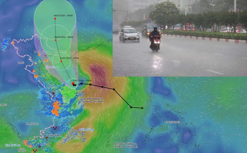
Forecast of 2 scenarios of path and impact of storm No. 1
|
Scenario with a probability of 70%, storm No. 1 will pass through the Northern Gulf of Tonkin area and move north towards Quang Ninh (Vietnam) before entering southern Guangxi (China).

Typhoon No. 1 with gusts of level 11 enters Quang Ninh sea area in the next 24 hours
|
Forecast for the next 24 hours, storm No. 1 will move in a North-Northwest direction, entering the sea area of Quang Ninh. The strongest intensity is about level 8-9, gusts level 11.

Storm No. 1 Maysak caused the heaviest rain in Quang Ninh, Hai Phong, Lang Son and Bac Ninh
|
The meteorological agency warns that the Northeast region needs to be wary of heavy rain due to the circulation of storm No. 1. Rain is concentrated in Lang Son, Quang Ninh, Hai Phong and Bac Ninh.

Storm No. 1 causes heavy rain from tonight, warning of the risk of thunderstorms and tornadoes before making landfall
|
The meteorological agency especially warned that it is necessary to be wary of the risk of thunderstorms, tornadoes and strong gusts of wind even before and during storm No. 1's landfall.

Forecast of heavy rain in 12 provinces and cities from tonight due to storm No. 1, in some places over 500mm
|
According to the latest forecast, due to the impact of storm No. 1, the Northeast and Thanh Hoa from the night of July 3rd to the end of July 5th will have heavy to very heavy rain, locally over 500mm.

Storm No. 1 strengthens to level 11 gusts, is about to cause heavy rain, forecast for the next 24 hours
|
Typhoon No. 1 has strengthened to level 8 - 9, gusting to level 11, causing heavy rain in the Northeast region from the night of July 3rd and entering the Gulf of Tonkin in the next 24 hours.
Hanoi weather forecast with thunderstorms from tomorrow July 4 due to the impact of storm No. 1
|
Hanoi weather forecast with rain, moderate rain, locally heavy rain and scattered thunderstorms on May 4 - 7 due to the impact of storm No. 1 Maysak.

Forecast of heavy rain in provinces and cities from tonight due to storm No. 1, in some places over 350mm
|
Forecast for the Northeast region and Thanh Hoa to have widespread heavy rain from tonight July 3 due to the impact of storm No. 1.

Storm No. 1 Maysak affected Quang Ninh, Hai Phong, and Hung Yen
|
For the coastal mainland area, storm No. 1 Maysak is affecting the coastal areas of Quang Ninh, Hai Phong and Hung Yen provinces.