The latest storm and low pressure information on April 28 from the Philippine Atmospheric, Geophysical and Astronomical Services Administration (PAGASA) shows that the low pressure near the East Sea is likely to strengthen into a storm.
The bulletin stated that during the week from April 28 to May 4, the low pressure near the East Sea will operate mainly in the southeast of the Philippine Forecast Area (PAR).
Forecast models show the depression will move east of Mindanao, Visayas and Southern Luzon in the Philippines.
During this forecast period, the low pressure near the Philippines is likely to strengthen into a storm, from medium to high.
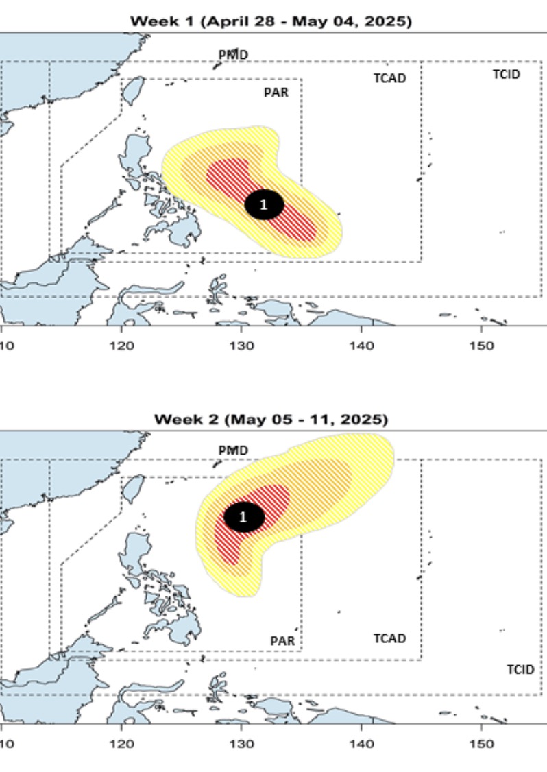
The latest storm forecast bulletin from PAGASA also shows that during the week from June 5 to May 11, the low pressure near the East Sea is likely to turn northeast as it affects the eastern coast of Southern Luzon.
During this period, the low pressure near the East Sea is likely to strengthen into a moderate to high storm. Therefore, within the next 2 weeks, storms near the East Sea are likely to appear.
At 2:00 p.m. on April 28, the low pressure near the East Sea, named LPA 04a, was located in the Philippine PAR forecast area. LPA 04a is about 710 km east of General Santos City, Philippines. According to Philippine weather experts, this low pressure is unlikely to strengthen into a tropical depression within the next 24 hours.
With the latest forecasts, LPA 04a is likely to become the first storm of the 2025 Pacific typhoon season. In February, a tropical depression formed in the East Sea but quickly dissipated.
According to PAGASA's list of typhoon names for the 2025 typhoon season, the first typhoon of the year will be locally named Auring.
Previously, PAGASA weather forecaster Daniel James Villamil said that on April 28, due to the combined impact of the low pressure and the intertropical convergence zone, scattered showers are forecast in Mindanao and the Palawan area. Thunderstorms have occurred in parts of Palawan and southern Mindanao. Many areas in Mindanao will have scattered showers and thunderstorms throughout the day.
As early as on April 28, the Davao and Soccsksargen regions of the Philippines were directly affected by the low pressure near the East Sea, with cloudy skies with scattered showers and thunderstorms.
Previously, Ariel Rojas - weather forecaster of ABS-CBN - commented that the low pressure near the East Sea could strengthen into a tropical storm on April 30 or May 1. The storm could pass through the central Philippines towards the South China Sea or around the eastern part of Luzon, he said. However, he noted that the forecast track and intensity of Auring remains uncertain.