The latest typhoon information from the Hong Kong Meteorological Station (China) on June 11 said that the storm warning signal No. 1 issued on the same morning was valid throughout the day as Typhoon Wutip (meaning butterfly in Chinese) was expected to maintain a distance of about 700km from Hong Kong (China).
The storm warning signal No. 1 was issued at 0:40 on June 11. Weather experts in Hong Kong (China) will continue to assess whether to raise the storm warning to level 3 in the next 2 days.
"The system is expected to gradually strengthen and move towards Hainan Island in the next few days. After that, this system will move towards the west coast of Guangdong. As the typhoon gets closer to coastal areas, there will be winds and occasional rain this weekend," the Hong Kong Meteorological Station (China) said.
Meanwhile, the latest typhoon report from Xinhua News Agency said that Hainan Province (China) maintained a level 4 typhoon warning on June 11 after the tropical depression in the East Sea strengthened into a No. 1 typhoon on the same morning. China has a four-level flood control emergency response system, of which level 1 is the highest.
The Hainan Provincial Meteorological Department determined that Typhoon Wutip had winds of up to 64 km/h, central pressure of 995 hectarespascal and caused up to 108.6 mm of rain between 8:00 a.m. on June 10 and 7:00 a.m. on June 11.
Experts predict that Wutip will move northwest at a speed of 10-15 km/h, gradually strengthening as it approaches the southeastern coast of Hainan Island. The storm is expected to make landfall in the Hainan island area on June 13.
Regarding the path of Typhoon No. 1 in the East Sea, the forecast from the Taiwan Meteorological Administration (CWA) said that Wutip will make landfall south of Hainan Island on the morning of June 13, passing west of the island before making landfall back to the southwest of the Lusian Peninsula on the morning of June 14, then moving northeast and weakening. The expected intensity that Wutip will reach is tropical storm level (maximum wind speed near the center of the storm is 80 km/h).
The Japan Meteorological Agency forecasts that Typhoon No. 1 in the East Sea will move northwest towards Hainan Island, making landfall east of the island on June 13, then turning northeast towards Zhamjiang and Mau Danh, Guangdong Province, China on June 14.
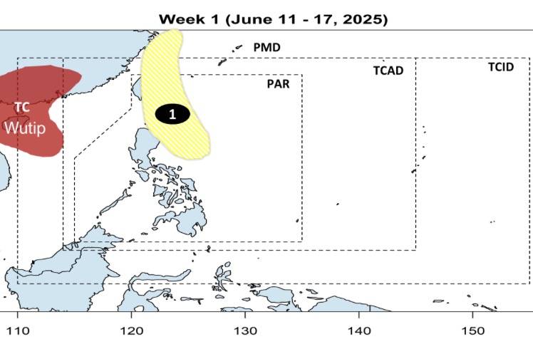
The latest storm forecast on June 11 from the Philippine Atmospheric, Geophysical and Astronomical Services Administration (PAGASA) said that during the week of November-February 17, Typhoon Wutip will continue to operate in the northern part of the East Sea and will not directly affect the weather in the Philippines.
However, during the time Typhoon No. 1 Wutip swept through the East Sea, a low pressure near the East Sea is likely to form east of Luzon, Philippines. This low pressure is expected to move north, towards Taiwan (China), with the possibility of strengthening into a low storm.
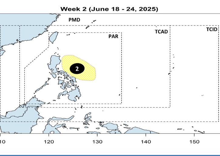
Forecast, during the week of June 18-24, weather models show another low pressure near the South China Sea to form in the eastern part of Luzon and the Visayas. Similarly, this low pressure near the Philippines is unlikely to strengthen into a storm.