On July 30, the Philippine Atmospheric, Geophysical and Astronomical Services Administration (PAGASA) issued a storm/low pressure forecast for the next 2 weeks.
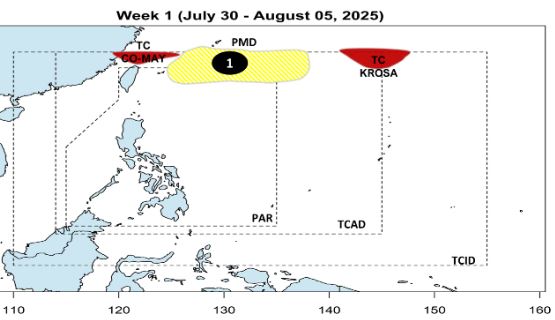
Accordingly, during the week of July 30 to August 5, 2025, there were two storms being monitored within PAGASA's monitoring area, but none of them directly affected the Philippines.
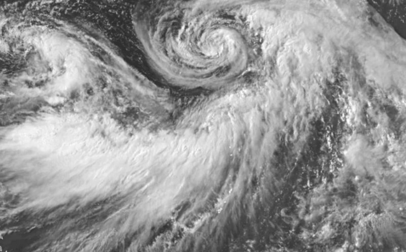
Comay (formerly storm No. 4 in the East Sea) is outside the Philippines PAR's forecast area. Comay made landfall in the port city of Zhoushan, Zhejiang Province, China in the early morning of July 30.
Meanwhile, Typhoon Krosa (also outside the PAR) will move south of Japan.
This week, there is a possibility of a low pressure area appearing in the north of PAGASA's forecast area, but the probability of forming a storm is low.
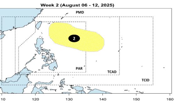
During the week of August 6-12, 2025, another low pressure may form east of the PAR area, but the possibility of forming a storm is also low.
According to the Vietnam National Center for Hydro-Meteorological Forecasting, from August to October 2025, it is expected that there will be about 6-8 storms/tropical depressions active in the East Sea, of which about 2-3 are likely to directly affect the mainland of Vietnam.
From November to December 2025, there may be 2-3 more storms/tropical depressions, of which about 1-2 are likely to make landfall.
For the Atlantic hurricane season, August is typically the time when hurricanes increase significantly in the Atlantic, Gulf of Mexico and Caribbean Sea - and the 2025 hurricane season may not be an exception.
Although the Atlantic hurricane season officially began on June 1, according to climate statistics, the number of storms has typically increased sharply since the beginning of August, with a peak usually falling on September 10.
AccuWeather's leading hurricane forecaster, Alex DaSilva, expressed special concern about the possibility of this year's storms increasing in intensity very quickly, due to unusually warm waters in the Gulf of Mexico, Caribbean and Atlantic waters. This environment increases the risk of a sudden storm strengthening as it approaches land - a phenomenon that has become increasingly common in recent years.
Hurricane Ian in 2022 is a typical example, when it increased from a Category 3 to a Category 5 storm in a short time, before making landfall in Florida (USA), causing serious damage.
Most recently, Hurricane Helene in 2024 also increased from Category 2 to Category 4 as it moved into the Southeast region of the United States, becoming the strongest storm ever recorded in Florida's Big Bend and causing terrible flooding in the states of Carolina.
Experts recommend that people living along the Atlantic coast and Gulf of Mexico should review their hurricane prevention plans now and stock up on necessities before the storm approaches.