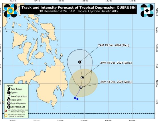
The latest storm and low pressure information at 5:00 a.m. on December 18 from the Philippine weather agency PAGASA said that tropical depression Querubin is maintaining its intensity over the sea in eastern Mindanao, Philippines.
Based on all available data, the center of the tropical depression is 230 km east of Davao City or 205 km east of Tagum City, Davao del Norte.
Tropical Depression Querubin is moving north-northeast at 10 km/h. The depression near the East Sea currently has maximum sustained winds near the center of 45 km/h and gusts of up to 55 km/h.
Philippine weather forecasters said that by 2 p.m. on December 18, the latest tropical depression was expected to be 165 kilometers east-southeast of Hinatuan, Surigao del Sur, Philippines.
It is expected that by 2:00 a.m. on December 19, tropical depression Querubin will be about 240 km east-southeast of Surigao city, Surigao del Norte.
The interaction of the tropical depression with wind shear is expected to bring heavy to very heavy rains to some areas in the Visayas and Mindanao, with rain possible in areas far from the tropical depression's projected track.
According to PAGASA, Tropical Depression Querubin is forecast to move north-northeastward or northward over the seas east of Mindanao within the next 24 hours.

It is forecasted that during this period, the tropical depression near the Philippines will weaken into a low pressure area. From December 19 to December 22, the low pressure area near the East Sea will pass through Mindanao, the Sulu Sea and Palawan.
PAGASA's storm and tropical depression forecasters warn that although Querubin has weakened, it still has the potential to strengthen into a tropical depression when it enters the East Sea.
Previously, in the storm and tropical depression forecast announced on December 16, PAGASA stated that the new tropical depression could enter the East Sea between December 23 and December 29. It is forecasted that the tropical depression has the potential to strengthen into a low to medium storm.


