Forecast of the path of the new low pressure immediately after storm Ha Long

Thanh Hà |

Like Typhoon Ha Long, the new tropical depression is unlikely to affect the weather in the Philippines.

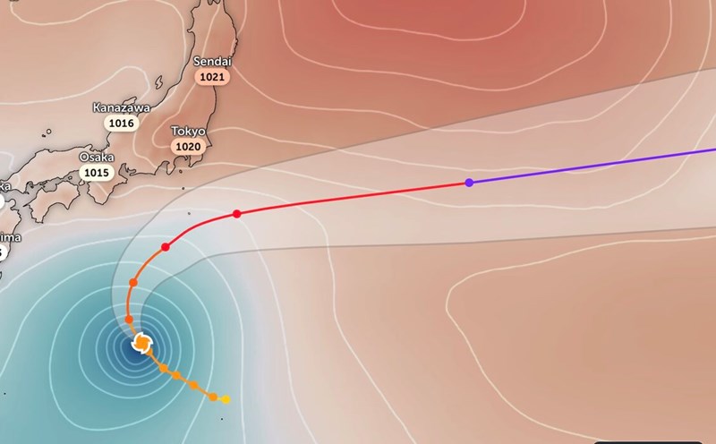
The latest storm and low pressure information from the Philippine Atmospheric, Geophysical and Astronomical Services Administration (PAGASA) said that Typhoon Ha Long is currently outside the Philippine Forecast Area (PAR) and is not expected to directly affect the country.

Meanwhile, the new low pressure area that PAGASA has been monitoring outside the PAR has strengthened into a tropical depression.

At 2:00 a.m. on October 8, the tropical depression was 1,985 km east of Luzon, with maximum sustained winds of 55 km/h and gusts of up to 70 km/h. The tropical depression is moving northwest at a speed of 15 km/h.

"This tropical depression will cross or enter part of the Philippine forecast area. We also do not rule out the possibility that this system could enter the PAR region in a short time or temporarily enter and then move far away," PAGASA weather forecaster Loriedin De La Cruz said in a bulletin at 5:00 a.m. on October 8.

Philippine weather forecasters say that like Typhoon Ha Long, the new tropical depression is unlikely to affect the weather in the Philippines.

The new tropical depression is also being monitored by the US Navy's Joint Typhoon Warning Center (JTWC), named Invest 95W.

The latest news from JTWC said that the new tropical depression is active in the Philippine Sea and is likely to strengthen further in the next 24 hours.

Area analysis shows that weather conditions are favorable for the development of this depression, with low wind shear and warm sea surface temperatures. The forecast model of the European Center for Medium-term Weather Forecasts (ECMWF) shows that this low pressure will strengthen steadily in the next 24 hours.

Regarding the track, global models agree that the new low pressure will move northwest, with maximum sustained surface winds of about 45-55 km/h.

Du bao ap thap moi quanh Bien Dong sau bao Ha Long do PAGASA cong bo ngay 6.10. Anh: PAGASA
A new low pressure forecast around the East Sea after Typhoon Ha Long was released by PAGASA on October 6. Photo: PAGASA

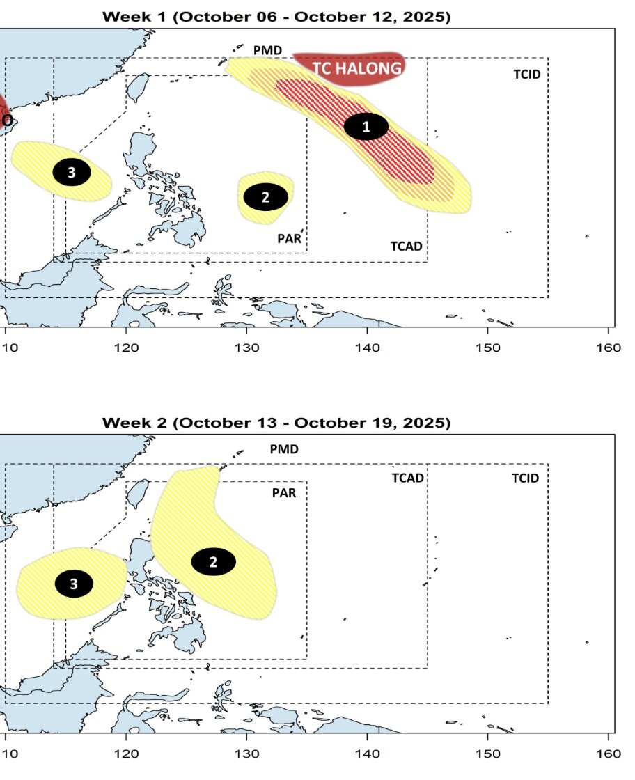
Previously, according to PAGASA's short-term storm forecast released on October 6, in addition to Typhoon Ha Long, PAGASA forecasted two more depressions in the area around the East Sea from October 6 to October 19.

Of which, the low pressure near the East Sea is forecast to form within the PAR during the week of October 6 to 12 and continue to strengthen, approaching the Philippines during the week of October 13 to 19.

Similarly, a low pressure in the East Sea is also forecast to form during the week of October 6 to 12 and continue to expand its range of activities in the East Sea from October 13 to 19.

Thanh Hà
RELATED NEWS

Storm Jerry appears, forecast to become a hurricane today

|

Jerry has formed and is expected to soon strengthen into the next Atlantic hurricane on October 8.

Storm Ha Long accelerates violently, changes direction as it nears reaching maximum intensity

|

Typhoon Ha Long is entering a period of intense acceleration in southern Japan, with the possibility of reaching its peak intensity on October 9.

Standing Deputy Secretary of Hanoi: If we are not flooded, if we are not late for work, it will be a happy time

|

The Standing Deputy Secretary of the Hanoi Party Committee said that in the document of the Hanoi City Party Congress, there is a very special criterion, which is "happiness".

Hanoi builds an additional bridge worth more than 7,300 billion VND across the Red River, to be completed in 2027

|

Hanoi - Thuong Cat Bridge and the road at both ends of the bridge, 5.226 km long, with a capital of more than VND 7,300 billion, have officially started construction, expected to be completed after 2 years.

Ecuador's President Escapes Assault

|

On October 7, Ecuadoran President Daniel Noboa was lucky to escape after his car was attacked by a crowd of people throwing rocks.

Flooding scene in the central Thai Nguyen area when the Cau River flooded above historical peak

|

Thai Nguyen - In the early morning of October 8, the water level of the Cau River at Gia Bay station exceeded the historical flood peak, many places were deeply flooded, traffic was paralyzed, people's lives were turned upside down.

Hanoi still has 12 deeply flooded spots

|

Hanoi - This morning (October 8), most of the city's central roads have been circulating normally, with only 12 flooded spots in the Nhue River basin.

Unlicensed electric vehicles are everywhere, safety is being left uncertain

|

The low-cost electric vehicle market has a series of unregistered, unregistered vehicles hand-cted from floating components, posing a potential risk of fire and explosion and unsafety.

Storm Jerry appears, forecast to become a hurricane today

Thanh Hà |

Jerry has formed and is expected to soon strengthen into the next Atlantic hurricane on October 8.

Storm Ha Long accelerates violently, changes direction as it nears reaching maximum intensity

Thanh Hà |

Typhoon Ha Long is entering a period of intense acceleration in southern Japan, with the possibility of reaching its peak intensity on October 9.

Dự báo áp thấp mới hướng về Biển Đông sau bão số 11, mưa lớn ngập nặng

Song Minh |

Ngay sau khi bão số 11 suy yếu, ngày 6.10 đã xuất hiện một vùng áp thấp mới ở phía đông Philippines với khả năng có thể vào Biển Đông nếu mạnh lên.