The latest storm/low pressure information from the Philippine Atmospheric, Geophysical and Astronomical Services Administration (PAGASA) said that at 2:00 a.m. on August 20, the center of low pressure 80e was at about 12.3 degrees north latitude, 135.5 degrees east longitude, 1,180 km east of Eastern Visayas. PAGASA forecasts that the low pressure is likely to strengthen into a tropical depression in the next 24 hours.
Meanwhile, the forecast from the US Joint Typhoon Warning Center (JTWC) said that the low pressure area that JTWC calls 90W is in the central Philippine Sea, north of Palau Island, causing scattered thunderstorms. According to satellite data, the low pressure is moving quite rapidly in the west-northwest direction. It is forecasted that in the next few days, the low pressure will have favorable conditions for development. However, the possibility of strengthening into a storm before entering the Philippines is not high.
According to weather forecasters from JTWC, when it enters the East Sea this weekend, the low pressure is likely to become a tropical depression, with a probability of the next 7 days estimated at 70%. The affected area is expected to focus on the area east of Hainan Island (China).
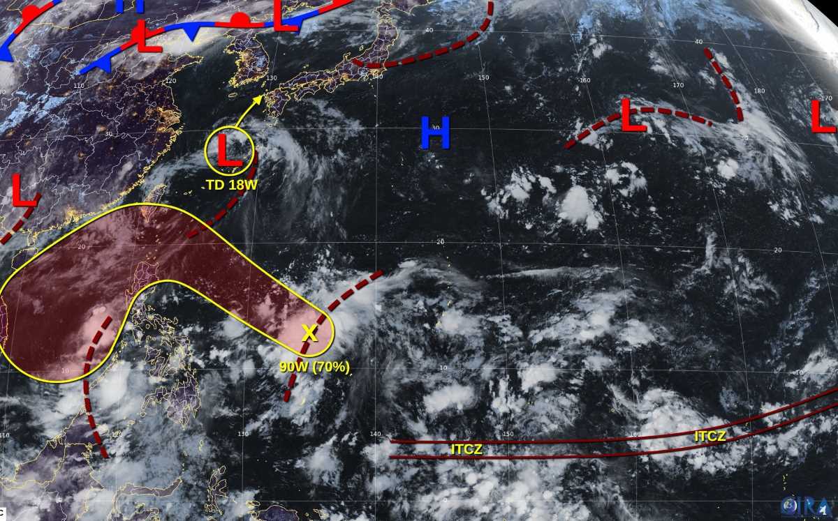
Before entering the East Sea, the low pressure may cause heavy rain on Luzon Island (Philippines) and southern Taiwan (China) for two days, August 21-22.
Meanwhile, according to the Vietnam National Center for Hydro-Meteorological Forecasting, on the day and night of August 20, in the Central and South East Sea (including the special waters of Truong Sa), there will be scattered showers and thunderstorms. During thunderstorms, there is a possibility of tornadoes, strong gusts of wind of level 6-7 and waves 1-2m high.
Regarding rain forecast, on the day and night of August 20, in the mountainous areas of the North, there will be rain, moderate rain and scattered thunderstorms, with rainfall of 15-35mm, locally heavy to very heavy rain over 100mm.
In the afternoon and night of August 20, in other areas of the North, Thanh Hoa and the South, there will be scattered showers and thunderstorms, with rainfall of 10-30mm, locally heavy rain over 60mm.
Regarding today's weather in Hanoi, the lowest temperature is 25-27 degrees Celsius, the highest temperature is 31-33 degrees Celsius.
Northwest: Lowest temperature 24-27 degrees Celsius, some places below 23 degrees Celsius. Highest temperature 31-34 degrees Celsius, Dien Bien and Lai Chau 28-31 degrees.
Northeast: Lowest temperature 24-27 degrees, some places below 24 degrees. The highest temperature is 31-34 degrees.
Thanh Hoa to Hue: Lowest temperature 24-27 degrees. The highest temperature is 32-35 degrees, in the South some places are over 35 degrees.
South Central Coast: Lowest temperature 24-27 degrees. The highest temperature is 32-35 degrees, some places are over 35 degrees.
Central Highlands: Lowest temperature 20-23 degrees. The highest temperature is 28-31 degrees.
Southern region: Lowest temperature 23-26 degrees. The highest temperature is 31-34 degrees.
Ho Chi Minh City: Lowest temperature 24-26 degrees. The highest temperature is 32-34 degrees.