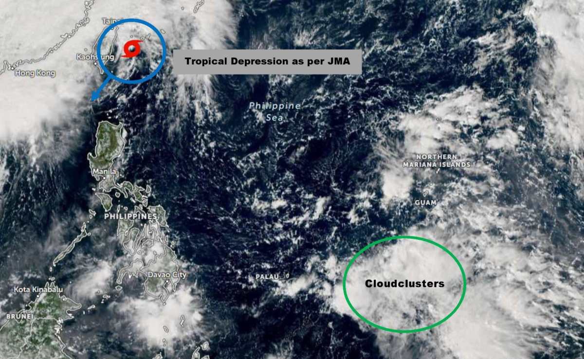
The latest typhoon information from the Japan Meteorological Agency (JMA) on October 21 said that a weak cyclone or tropical depression is forming northeast of the Philippine island of Batanes, near Taiwan (China).
Currently, the Philippine Atmospheric, Geophysical and Astronomical Services Administration (PAGASA) has not recorded any official low pressure areas in the Philippine Forecast Area (PAR). However, if it continues to strengthen and enter PAR, it will be named Salome - the 19th storm of 2025 in the Philippines.
According to the initial forecast, the northeast monsoon is pushing the system south, possibly approaching or sweeping across the northernmost part of Luzon, even affecting Ilocos Norte in the next few days.
Notably, in addition to the new low pressure mentioned above, international storm forecast models also recorded a new cluster of convective clouds forming near Yap Island (Micronesia) - an area that is often the "cradle" of strong storms. This cloud cluster is likely to develop into a low pressure area in the next few days, but it has not yet directly affected any area.
Regional meteorological agencies recommend that people closely monitor weather forecasts for this week, as the situation may change rapidly due to the simultaneous impact of the northeast monsoon, cold air and circulation after storm No. 12 Fengshen.
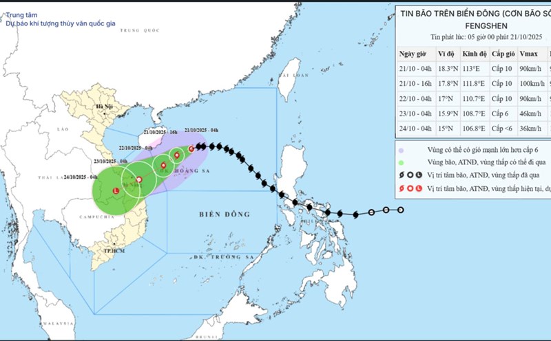
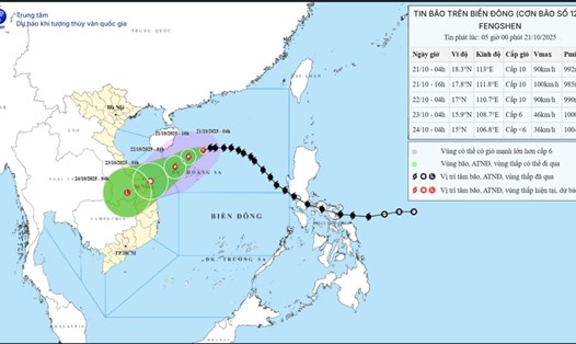
Meanwhile, according to the Vietnam National Center for Hydro-Meteorological Forecasting, at 1:00 p.m. on October 21, the center of storm No. 12 was at about 17.5 degrees North latitude; 112.2 degrees East longitude, in the sea north of the Hoang Sa archipelago, about 450km East Northeast of Da Nang. The strongest wind near the storm center is level 9-10 (75-102 km/h), gusting to level 12. The storm is moving southwest at a speed of 10-15 km/h.
It is forecasted that by 1:00 p.m. on October 22, storm No. 12 will move in the West Southwest direction, at a speed of 10-15 km/h, the center of the storm will be at about 16.2 degrees North latitude; 109.6 degrees East longitude, about 145km East Northeast of Da Nang. Strong wind level 8, gust level 10, gradually weakening.
At 1:00 p.m. on October 23, the storm continued to move in a West-Southwest direction, at a speed of 10-15 km/h, moving inland from Quang Tri to Da Nang, then gradually weakening into a tropical depression and then a low pressure area over the South Laos region (15.0 degrees North latitude - 107.1 degrees East longitude). Wind power below level 6.
Due to the influence of the circulation of storm No. 12 combining cold air and East wind, terrain effects, from noon on October 22 to October 27, the area from Ha Tinh to Quang Ngai will have heavy to very heavy rain, concentrated most strongly from the afternoon of October 22 to the end of October 23. Ha Tinh - Bac Quang Tri and Quang Ngai: 200-400mm, some places over 500mm. South Quang Tri - Da Nang: 500-700mm, some places over 900mm.
Warning of very heavy rain (over 200 mm/3 hours). Heavy rain in the Central region is likely to last until the end of October 2025.
There is a very high risk of flash floods, landslides in mountainous areas; flooding in low-lying, low-lying areas and urban areas.
Localities need to proactively operate hydropower and irrigation reservoirs safely; prepare response plans when the river water level from Quang Tri to Quang Ngai is likely to reach or exceed alert level 3.