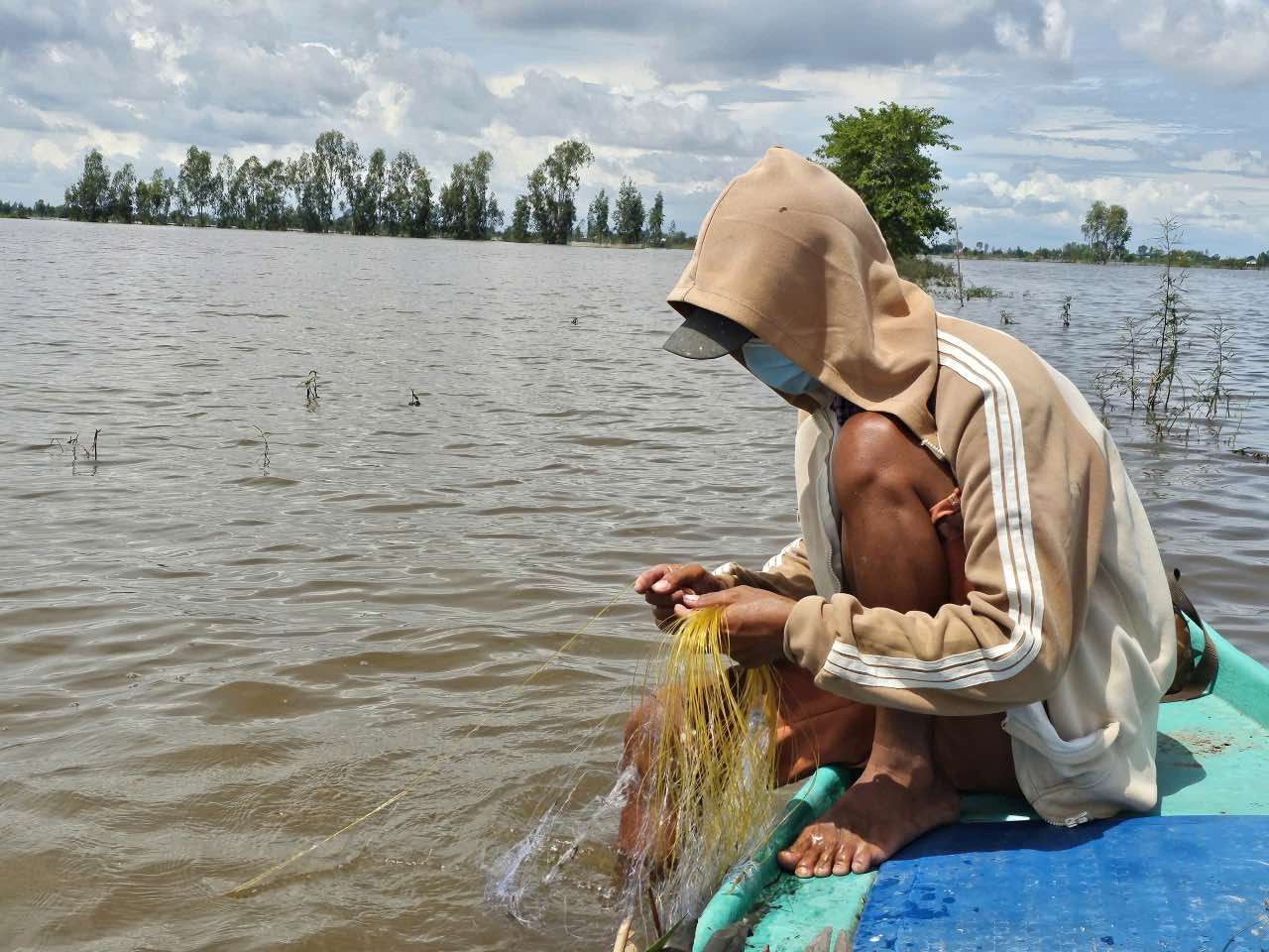
According to the Irrigation Department of Dong Thap province, in August, water levels in many places in the province were affected by the combination of high tides from the East Sea and upstream floods. During the month, there were 2 high tides at quite high levels; the end-of-source area reached level I - II alarm level. In general, the water level in places in the province is approximately 0.1 - 0.2 m higher than the same period in 2024.
Specifically, in the upstream area, the highest water level in August 2025 is 8 - 39 cm higher than the same period in 2024 and 10 - 22 cm higher than the average of many years (at Tan Chau and Hong Ngu stations alone, it is 36 - 44 cm lower).
In the Thap Muoi inland area, the highest water level in August 2025 is 4 - 14 cm higher than the same period in 2024 (less than 8 cm at My An station alone), 1 - 4 cm higher than the average of many years (less than 36 cm at Tram Chim station alone).
For the southwestern and upstream areas, the highest water level in August 2025 is 5 - 28 cm lower than the same period in 2024, but 26 - 39 cm higher than the average of many years.
According to the Dong Thap Hydrometeorological Station, from the end of August to mid-October 2025, water levels in places in the province will continue to increase due to the influence of high tides combined with floods in the upper Mekong River. The flood peak in the upstream area is expected to appear in the first half of October, reaching level I alarm level, with water levels in Tan Chau about 3.5 m and in Hong Ngu about 3.4 m - 0.1 - 0.3 m higher than the same period in 2024. The flood peak in the Thap Muoi inland area is also expected to appear in the first half of October, reaching level II - III alarm level; in which, at Truong Xuan, the water level can reach about 2.3 m, about 0.1 m higher than in 2024.
The highest high tide peak in 2025 in the southwestern and southern part of Dong Thap province is expected to appear in 2 phases: Phase 1 from October 8 to 10, 2025 (ie August 17 to 19 of the lunar calendar), Phase 2 from November 6 to 8, 2025 (ie September 17 to 19 of the lunar calendar).
The water level during these tides is forecast to be 0.1 - 0.3 m higher than the level III alarm; specifically, in Cao Lanh about 2.5 m and in My Tho about 1.9 m. Compared to the same period in 2024, the water level this year is approximately 0.05 - 0.10 m higher. In general, the highest water level in 2025 in places in Dong Thap province will fluctuate at approximately the same level and will be about 0.1 - 0.3 m higher than in 2024.
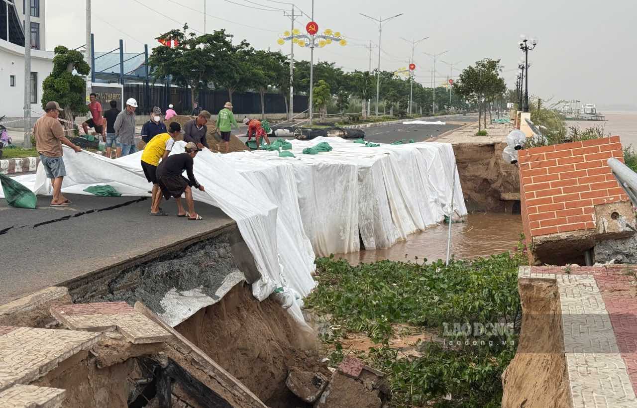
According to the Department of Irrigation of Dong Thap province, from the beginning of the year to August 30, 2025, there has been a lot of damage due to landslides, heavy rain with thunderstorms, and lightning in the area, causing a loss of about 191.7 billion VND. Specifically: 2 people died due to lightning, 21 people were injured; 732 houses were affected (of which 73 houses collapsed, 659 houses had their roofs blown off).
In addition, there have been 7 landslides on the Tien River, including 1 serious incident at the Thuong Thoi Tien embankment (Thuong Phuoc commune). In addition, there were 100 landslides in the fields and subsidence with a total length of more than 14.9 km, collapsing 1 house.
To proactively prevent, combat and overcome the consequences of natural disasters in the coming time, in order to minimize damage to people and property, the Head of the Irrigation Department of Dong Thap province has issued a document requesting the People's Committees at the commune level in the area to closely monitor the development of natural disasters and proactively respond to bad situations. In addition, regularly update forecasts, warnings of rain, thunderstorms, lightning and dangerous weather phenomena from specialized agencies. At the same time, promote propaganda and dissemination of documents on natural disaster prevention on mass media so that people can grasp and proactively prevent.
In addition, strengthen inspection of dykes, dams, and irrigation pumps; promptly reinforce low-lying, vulnerable dykes and degraded dykes; develop a plan for irrigation to protect agricultural production and regularly inspect and monitor key points at risk of landslides to promptly handle and minimize risks.