According to the Vietnam Road Administration, the provinces from Ha Tinh to Da Nang will have moderate winds and rain, locally heavy rain.
The eastern provinces from Quang Ngai to Dak Lak will have heavy rain and strong winds; after the storm, there will still be rain due to the influence of the storm's circulation.
After making landfall, early this morning (November 7, 2025), storm No. 13 weakened into a low pressure area in the Ha Lao area.
After storm No. 13, the damage situation is as follows:
For the road area managed by the Central Government: Ho Chi Minh Road West Branch still has 05 traffic jam locations: at Km396+050, Km407+460, Km407+950, Km408+040, Km408+350.
Expected to open to traffic on November 7, 2025; in which, the bridge at Km396+050 is damaged, the Ministry of Construction has declared a natural disaster emergency in Decision No. 1946/QD-BXD dated November 4, 2025.
In the area of National Highway III: Many trees and electric poles broke and fell onto the road, corrugated iron roofs and objects flew onto the road, especially on National Highway 1 and Truong Son Dong Road in Gia Lai and Dak Lak provinces, which were the focus of the storm; in particular, on National Highway 1 through Song Cau, Tuy An, Dong Hoa (Dak Lak province) and on Truong Son Dong road (Gia Lai province), there were many broken trees blocking traffic.
Initial damage was recorded: Many places had power outages, many road signs were broken.
Currently, regular maintenance units have been cutting and clearing to promptly open the road to traffic immediately.
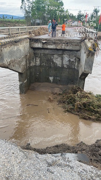
Truong Son Dong Road: At Dak Po To Bridge location Km378+130 Truong Son Dong Road, Gia Lai Province, floodwaters washed away the bridgehead road near M1 abutment, about 25m long, about 8m deep; QLDB III has fenced off both ends and assigned guards, mobilized steel baskets and boats to repair the problem, expected to reopen to traffic at 14:00 on November 7, 2025.
The National Highway III has notified the Gia Lai Department of Construction and local authorities of the damage and traffic congestion on Truong Son Dong Street and coordinated to divert traffic and immediately deploy the repair of Dak Po To Bridge Km378+130.
The section Km390+500 - Km391+400 was flooded with water from 1.2m - 1.8m; at the time of reporting, the flooding depth was 0.8m, the section of the road was completely flooded.
The section Km402 - Km402+700 was flooded with an average of 1.2m - 1.4m of water, at the time of reporting the flooding depth was 0.7m, the section of the road was completely flooded.
The section Km404+100 - Km404+350 was flooded with an average of 1.2m - 1.4m; at the time of reporting, the flooding depth was 0.7m, the section of the road was completely flooded.
These flooded locations have been fenced off and have signs prohibiting the roads, informing localities.
National Highway 1: The section passing through Quang Ngai province, fallen trees, creating more potholes on the road surface, some lighting poles on the bridge were tilted, breaking the bridge railing, and a negative slope landslide caused the Km1119 wave guard to be disrupted, about 50m long (with warning barriers). At Km1121+850/QL.1 (near Chau Me), the water was 15cm - 30cm deep, causing slow traffic. The BDTX contractor is continuing to monitor to warn and regulate if the water continues to flood deeper.
The Vietnam Road Administration statistics show that national highways managed by localities have suffered many damages.
The Da Nang Department of Construction said that on the night of November 6, 2025, the Km82/QL.40B section was eroded, causing traffic jams, and is expected to open to traffic on November 7, 2025.
Quang Tri Department of Construction, there are 3 flooded locations, specifically:
National Highway 15D: Da Krong spillway/Km0+307-QL15D is flooded 0.5m; traffic jam.
QL.49C:Km33+600÷Km34+100; Km35+200÷Km35+450 in Vinh Dinh commune: Flooded (10÷):):): founder.


