Image of the Red River through Lao Cai after the impact of storm No. 11

Đinh Đại |

Lao Cai - The water level of the Red River did not rise too high after the impact of storm No. 11.

According to the Department of Agriculture and Environment of Lao Cai province, in the past 12 hours, due to the influence of the low pressure area weakened by storm No. 11, Lao Cai province has had moderate to very heavy rain.

Rainfall recorded at some locations such as Trinh Tuong 1: 200.8 mm; Trinh Tuong: 98.2 mm (Trinh Tuong); Yen The: 175.8 mm (Tan Linh); A Mu Sung: 70.2 mm (A Mu Sung); Ban Cam: 81.4 mm; Phong Hai: 74.4 mm (Phong Hai)...

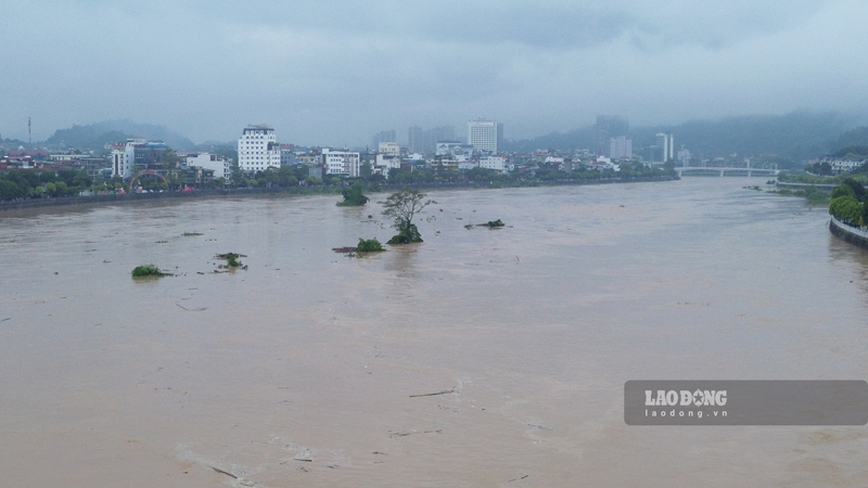
In terms of hydrology, the Thao River at Lao Cai station is rising rapidly; the water level at 1:00 p.m. reached 79.50 m (less than BD1: 0.50 m), at 2:00 p.m. reached 79.70 m and at 3:00 p.m. reached 80.00 m (reaching BD1), at 4:00 p.m. reached 80.20 m.

Yen Bai station changes slowly; Ngoi Thia stream changes slowly according to the regulation of upstream hydropower plants; Chay river at Bao Yen station fluctuates and increases according to the regulation of Bac Ha and Vinh Ha hydroelectric reservoirs.

The water level at 1:00 p.m. on October 7 at Yen Bai station was 27.90 m (under BD1: 2.00 m); Ngoi Thia river 39.94 m (under BD1: 4.56 m); Chay river at Bao Yen 79.22 m (not yet reached the warning level).

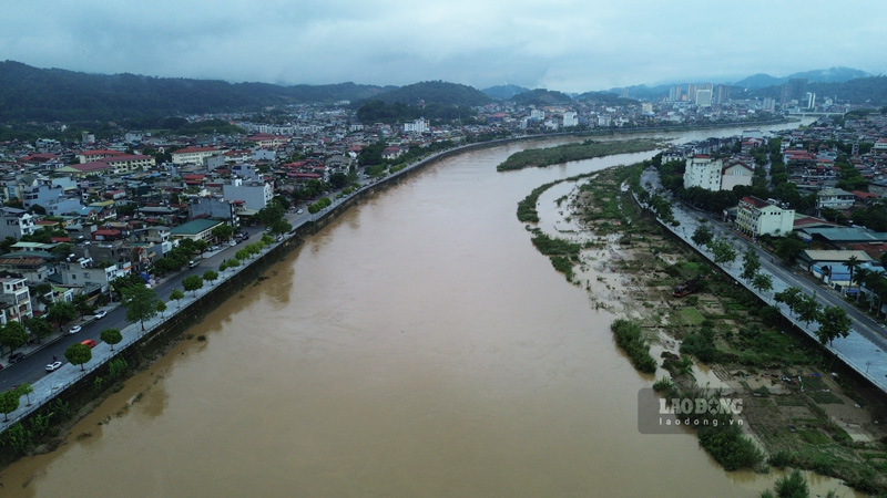
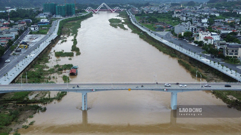
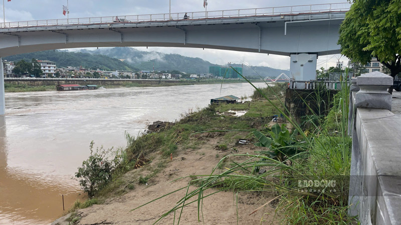
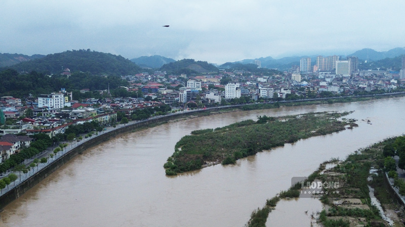
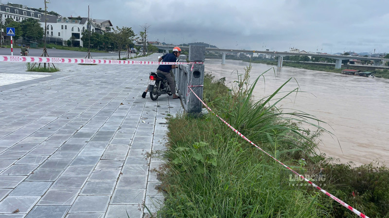
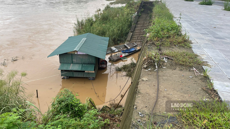
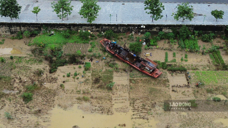
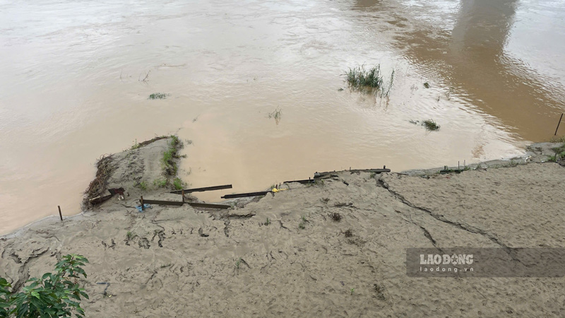
On the morning of October 8, according to the reporter of Lao Dong Newspaper on the Red River, the section flowing through Lao Cai Ward showed that the river water was flowing rapidly, but the water level did not rise too high.

In reality, compared to the time of many days of heavy rain due to the impact of storm No. 10, the water level on the river has decreased significantly, revealing sand dunes and large trees in the middle of the river.

Muc nuoc tren song Hong qua Lao Cai da giam nhieu sau con bao so 10, qua hinh anh con cat giua long song. Anh: Dinh Dai
The water level on the Red River through Lao Cai has decreased significantly after storm No. 10, through the image of sand dunes in the middle of the river. Photo: Dinh Dai

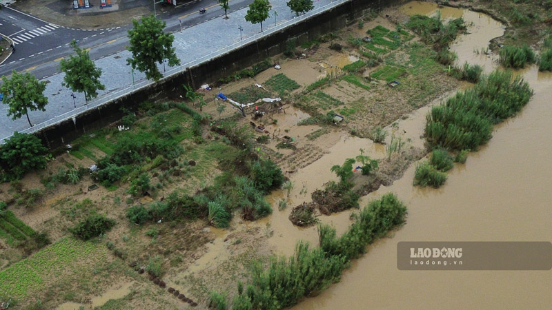
Along with that is the damage to crops and short-term vegetables when people cultivate along the flooded riverbank.

It is forecasted that in the next 6 hours, some places in Lao Cai province will have rain, moderate rain, some places will have heavy rain, the accumulated rainfall will be 30 - 50mm, some places will have over 70mm.

From the night of October 7 to October 8, there is a possibility of a flood on rivers and streams in the province, with a flood amplitude of 2-5m.

During this flood, the peak water level of the two floods on rivers and streams is likely to be at level BD1-BD2, some places above level 2. Rising river water levels can cause flooding in low-lying areas along the river.

Recorded water level of the Red River on the morning of October 8 through Lao Cai ward. Video: Dinh Dai

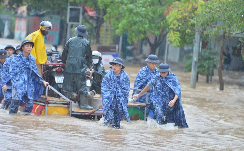
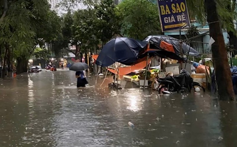
In addition, due to the impact of heavy rain with high intensity, there is a high risk of flooding in some communes and wards: Lao Cai ward, Cam Duong ward, Muong Khuong commune, Luc Yen commune, Muong Lai commune, Phuc Loi commune, Tan Linh commune, Tran Yen commune... with a flooding depth of 0.3 - 0.5m, some places over 0.6m; flooding time from 30 - 60 minutes, some places have longer flooding time.

The authorities have warned that in the next 6 hours, there is a risk of flash floods on small rivers and streams in mountainous areas; landslides on steep slopes, subsidence; flooding in low-lying areas, along rivers and streams, urban areas.

Some images of the Red River water level recorded on the morning of October 8:

Nuoc song Hong giam manh so voi thoi diem bao so 10. Anh: Dinh Dai
The Red River water level has decreased sharply compared to the time of storm No. 10. Photo: Dinh Dai
Con cat giua song va bai boi ven song da lo ra sau khi nuoc rut. Anh: Dinh Dai
The sand dunes between the river and the alluvial plains along the river have been exposed after the water receded. Photo: Dinh Dai
Mot so khu vuc duoc cang day de dam bao an toan. Anh: Dinh Dai
Some areas have ropes stretched to ensure safety. Photo: Dinh Dai
De lai sau lu la bun dat va thiet hai ve hoa mau canh tac doc long song. Anh: Dinh Dai
After the flood, mud and damage to crops along the riverbed were left. Photo: Dinh Dai
Đinh Đại
RELATED NEWS

Lao Cai seeks solutions to the problem of flooding along the Red River

|

Lao Cai is developing a plan to solve the problem of flooding and inundation in the area along the Red River from the beginning of Tran Yen commune to the end of Yen Bai ward.

Rising water flooded roofs, the banks in the middle of the Red River were isolated, people urgently evacuated

|

Hanoi After the historic rain caused by the circulation of storm No. 10, the water level of the Red River rose, while the Kim Nguu River became clear.

The water level of the Red River through Lao Cai is the highest since the beginning of the season

|

Lao Cai - Due to the impact of storms and floods, the water level of the Red River has risen the highest since the beginning of the season.

Standing Deputy Secretary of Hanoi: If we are not flooded, if we are not late for work, it will be a happy time

|

The Standing Deputy Secretary of the Hanoi Party Committee said that in the document of the Hanoi City Party Congress, there is a very special criterion, which is "happiness".

Hanoi builds an additional bridge worth more than 7,300 billion VND across the Red River, to be completed in 2027

|

Hanoi - Thuong Cat Bridge and the road at both ends of the bridge, 5.226 km long, with a capital of more than VND 7,300 billion, have officially started construction, expected to be completed after 2 years.

Ecuador's President Escapes Assault

|

On October 7, Ecuadoran President Daniel Noboa was lucky to escape after his car was attacked by a crowd of people throwing rocks.

Flooding scene in the central Thai Nguyen area when the Cau River flooded above historical peak

|

Thai Nguyen - In the early morning of October 8, the water level of the Cau River at Gia Bay station exceeded the historical flood peak, many places were deeply flooded, traffic was paralyzed, people's lives were turned upside down.

Hanoi still has 12 deeply flooded spots

|

Hanoi - This morning (October 8), most of the city's central roads have been circulating normally, with only 12 flooded spots in the Nhue River basin.

Lao Cai seeks solutions to the problem of flooding along the Red River

Văn Đức |

Lao Cai is developing a plan to solve the problem of flooding and inundation in the area along the Red River from the beginning of Tran Yen commune to the end of Yen Bai ward.

Rising water flooded roofs, the banks in the middle of the Red River were isolated, people urgently evacuated

Hữu Vũ - Thiện Nhân |

Hanoi After the historic rain caused by the circulation of storm No. 10, the water level of the Red River rose, while the Kim Nguu River became clear.

The water level of the Red River through Lao Cai is the highest since the beginning of the season

Đinh Đại |

Lao Cai - Due to the impact of storms and floods, the water level of the Red River has risen the highest since the beginning of the season.