The National Oceanic and Atmospheric Administration (NOAA) has just released its latest hurricane forecast on September 10, warning of the risk of storms and tropical depressions increasing in the second half of September in many large basins.
According to NOAA, over the past several months, convective signals have been intensifying in the Indian Ocean - Southeast Asia - West Pacific region, while Africa has recorded a weakening convection. Meteorologists say the phenomenon is linked to a weak La Nina trend in the Pacific Ocean.
The arrival of Kelvin has increased convection in the Americas last week. Forecast models show that the Madden-Julian (MJO) fluctuations may return to the Western Hemisphere by the end of September, fuelling tropical cyclone activity.
The storm has appeared in succession in the East half of the bridge. In the first week of September, a series of systems have formed: Typhoon Peipah (4.9) affected southern Japan.
Storm No. 7 Tapah (September 6) strengthened in the East Sea and made landfall in Guangdong province (China).
Tropical Depression No. 3 (September9) appears abnormally in the South Indian Ocean, outside the storm season.
Another low pressure area (Invest 93S) is being closely monitored in the same area.
Meanwhile, the Western Hemisphere is quite quiet, despite being in the midst of the Atlantic hurricane season. Only Kiko continued to move north of Hawaii, causing large waves but not making landfall directly.
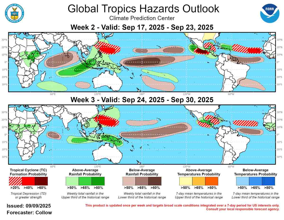
Forecast of storm risks in the East Pacific and Atlantic
Week from September 17-23
There is a probability of over 60% of the formation of 1-2 more tropical cyclones in southern Mexico and the eastern Pacific.
The Western Caribbean and Gulf of Mexico may see low pressure but have lower confidence (20-40%).
Off the coast of Africa, strong tropical waves could develop into typhoons, with a probability of 40-60%.
Week from 24-30/9
The convective environment in the East Pacific may be inhibited, but the risk of storms remains 20-40%.
The Atlantic continues to be a hot spot, especially the eastern area near the Cabo Verde Islands. A tropical wave expected to leave the West African coast around September 20 is likely to become a notable storm center.
The Northwest Pacific and Indian Ocean are still full of risks
Although the MJO in the Western Hemisphere typically reduces convection in the Pacific Ocean, the atmosphere in this area is still in a "highly hot" state, so the possibility of a typhoon forming 40-60% near and east of the Philippines in the last 2 weeks of September cannot be ruled out.
The risk of further cyclones in the South Indian Ocean remains a concern, although models have not yet pointed to a clear system outside the 93S.
Forecast of rain in the next 2-3 weeks:
Higher than average rainfall: East India, Southeast Asia, the West Pacific and the tropical regions of the Americas.
Lower than average rain: Central Pacific equatorial (possible over 80%), associated with a drop in sea surface temperatures.
In the second half of September, the global tropical map is forecast to " record waves" with the risk of consecutive storms and depressions in all three major basins. This signals a turbulent storm season, requiring coastal countries, including Vietnam, to be especially vigilant.


