The latest storm news on the morning of November 4 from the Philippine Atmospheric, Geophysical and Astronomical Services Administration (PAGASA) said that typhoon Kalmaegi made a second landfall at 5:10 a.m. on the same day in Borbon, Philippines.
PAGASA expert Chenel Dominguez informed: "Up to now, the storm continues to cross a large area of land over the Negros Island and part of Western Visayas."
Typhoon Kalmaegi made its first landfall in the Philippines in Silago, South Leyte at 0:00 on November 4.
PAGASA's storm bulletin updated at 8:00 a.m. said that according to all available data, including Masbate and Iloilo Doppler Weather Radars, the eye of storm Kalmaegi is in the vicinity of Sagay city, Negros Occidental. The storm is moving west-northwest at a speed of 25 km/h. Maximum sustained winds are 150 km/h near the center and gusts of up to 185 km/h.
PAGASA forecasters said that Typhoon Kalmaegi will pass through the Visayas and northern Palawan until it enters the South China Sea, becoming the 13th typhoon in the South China Sea on November 5. The storm will continue to move deep into the central East Sea and until 5:00 a.m. on November 7, the storm will move in the sea near Gia Lai, Vietnam, 1,310km from Central Luzon, Philippines.
"Due to terrain interaction, Typhoon Kalmaegi may weaken slightly as it passes through the Visayas. However, Kalmaegi is expected to maintain typhoon status throughout its journey through the Philippines, PAGASA said.
While Typhoon Kalmaegi is sweeping, Low Pressure Area 11a being monitored outside the PAR has strengthened into a tropical depression. The tropical depression could become a storm, moving into the PAR region later this week and be locally named Uwan.
This potential storm could head toward Northern Luzon, Philippines next week. Many forecasts show that this storm could enter the East Sea and become storm No. 14.
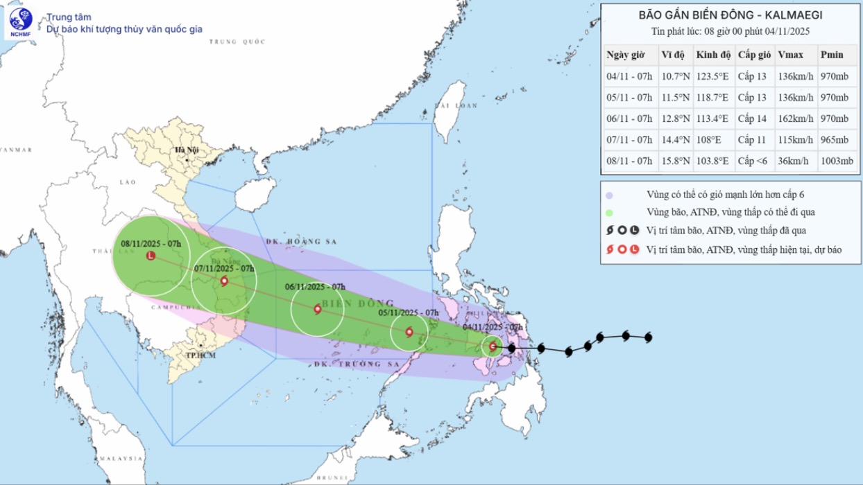
According to the storm near the East Sea (storm Kalmaegi) at 8:00 a.m. on October 4 of the Vietnam National Center for Hydro-Meteorological Forecasting, at 7:00 a.m. on November 4, the center of the storm was at about 10.7 degrees north latitude; 123.5 degrees east longitude, in the central Philippines. The strongest wind near the storm center is level 13 (134-149 km/h), gusting to level 16. The storm is moving west-northwest at a speed of about 20 km/h.
Weather forecasters from the Vietnam National Center for Hydro-Meteorological Forecasting predict that by 7:00 a.m. on November 7, storm Kalmaegi will be at 14.4 degrees north latitude, 108.0 degrees east longitude, on the mainland of the provinces from Quang Ngai to Dak Lak. The storm will then move west-northwest, at a speed of about 25 km/h. At this time, the storm has gradually weakened, at level 10-11, gusting to level 13.
It is forecasted that in the next 72 to 96 hours, the storm will move mainly in the west-northwest direction, traveling 20-25km per hour, and its intensity will continue to weaken.


