Forecast intensity of Typhoon Basyang when entering the East Sea

Khánh Minh |

Typhoon Basyang is accelerating as it approaches the Philippine island of Mindanao before it is forecast to enter the East Sea around the end of the week.

According to the latest storm news from the Philippine Atmospheric, Geophysical and Astronomical Services Administration (PAGASA), at 10:00 AM on February 5th, the center of Typhoon Basyang was located at about 8.0 degrees north latitude, 125.0 degrees east longitude, about 295km east of Hinatuan town, Surigao del Sur province.

The strongest wind near the storm center is about 65 km/h, gusting 80 km/h and is moving west-southwest at a fairly fast speed, about 25 km/h.

Along with accelerating, Basyang also forced PAGASA to raise the wind warning level.

Wind signal No. 2 has been issued in 10 provinces, including Surigao del Norte, Surigao del Sur, the northernmost Davao Oriental area, Agusan del Norte, Agusan del Sur, Camiguin, Misamis Oriental, the northern Bukidnon area, northeastern Lanao del Norte and northeastern Misamis Occidental.

Wind signal number 1 is applied in about 30 other areas.

Typhoon forecasts show that Typhoon Basyang is likely to strengthen further before making landfall for the first time, likely in Surigao del Sur at the end of February 5 or early morning of February 6.

Dự báo đường đi của bão Basyang. Ảnh: PAGASA
Forecast of Typhoon Basyang's path. Photo: PAGASA

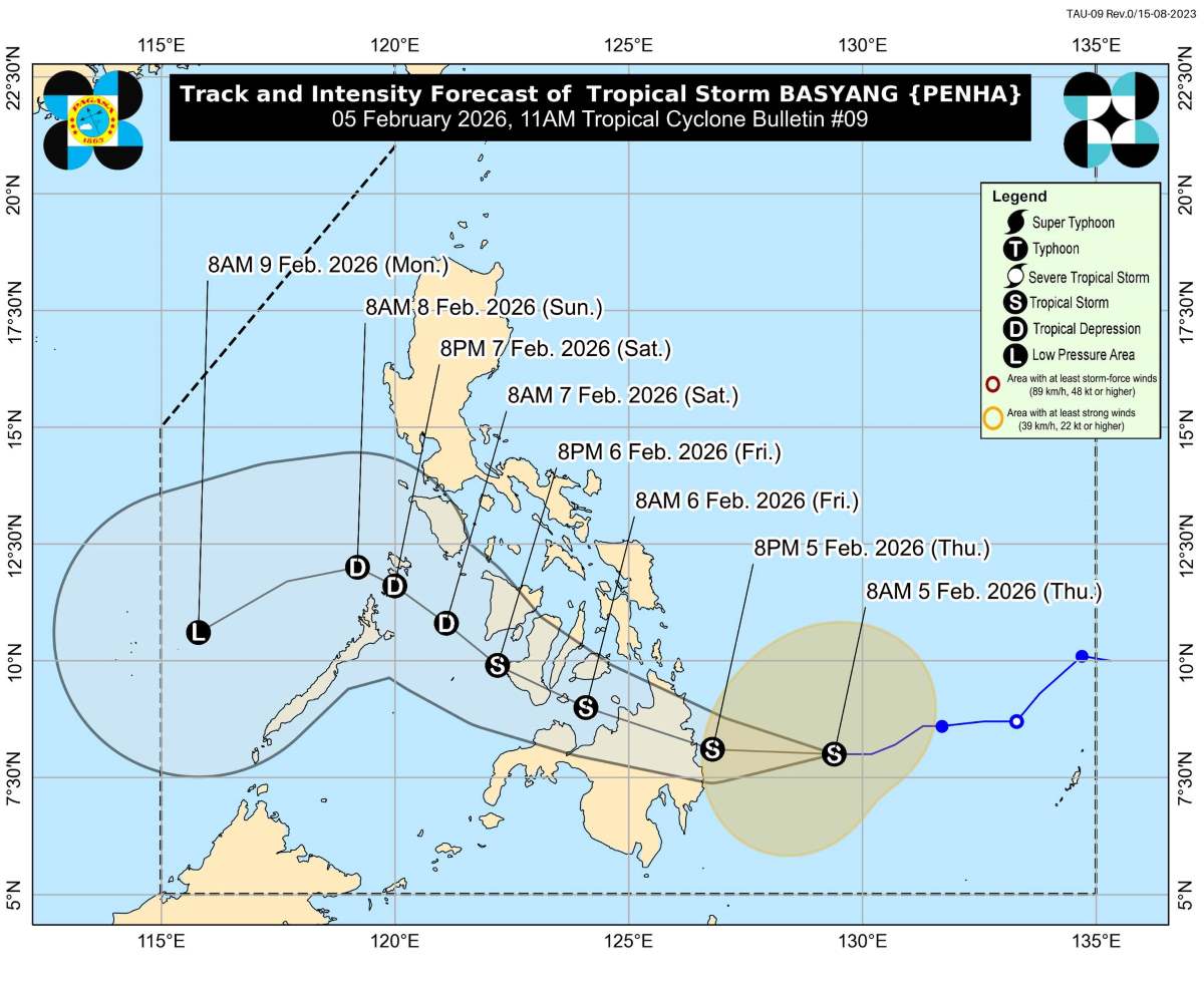
After entering the mainland, the storm is forecast to gradually weaken but still maintain tropical storm intensity when sweeping through the northeast of Mindanao, Siquijor Island and south of Negros Island until the afternoon of February 6.

When continuing to move westward, the typhoon is likely to weaken into a tropical depression before crossing the northern Palawan area in the afternoon or evening 7. 2. PAGASA said that after that, when entering the East Sea, Typhoon Basyang may weaken into a remaining low pressure area.

This is also a period that experts closely monitor to assess the impact of this weather circulation when approaching the East Sea.

Regarding weather impacts, Typhoon Basyang is forecast to cause widespread heavy rain. On February 5 and 6, significant rain will cover many areas in Visayas and Mindanao. By February 7, Mimaropa and Western Visayas will be the main areas affected by rain due to typhoon circulation.

PAGASA warns that heavy to very heavy rain is likely to occur in the northern and eastern areas of Mindanao, as well as the central and western areas of Visayas. With heavy rainfall in a short time, the risk of serious flooding and widespread landslides is assessed as very high in many areas of Mindanao, Visayas and southern Luzon Island.

Faced with the complicated developments of Typhoon Basyang, Philippine authorities recommend that people continuously monitor storm forecast bulletins, the latest warnings from the meteorological agency, and proactively implement measures to protect lives and property.

People in high-risk areas are required to strictly comply with evacuation orders when issued, in order to minimize damage caused by storms and floods.

Khánh Minh
RELATED NEWS

Cold air causing rain is coming soon, winter is changing the rules of the game

|

The cold air forecast this weekend will cause severe cold and rain, amid experts warning that winter is changing the rules of the game.

Forecast of the most severely affected area when Typhoon Basyang enters the East Sea

|

It is forecast that tropical depression Basyang will strengthen into a storm in the early morning of February 5th and enter the East Sea this weekend.

Tropical depression is about to strengthen into a storm, entering the East Sea

|

Tropical depression Basyang is forecast to strengthen into a storm today and is expected to soon enter the East Sea.

Standing Secretary of the Secretariat Tran Cam Tu: Prioritize resources to care for Tet for the people

|

Da Nang - Standing Secretary of the Secretariat Tran Cam Tu presents Tet gifts to the poor and workers of Da Nang, encouraging people to rise up after a year of fierce natural disasters.

English teacher corrects exam papers, lowers student scores, is warned, and stops teaching

|

Gia Lai - English teacher arbitrarily revises exam papers, lowers student scores, is disciplined with a warning, and stops teaching work after a reflection from Lao Dong Newspaper.

Silver prices plummet, many people leave because it is too difficult to buy

|

On February 5th, domestic silver prices reversed and fell sharply. In Hanoi, many people sought to buy silver but had to leave because it was difficult to buy.

Land plot prices increase sharply, forecast to be the leading segment in the market in 2026

|

Land plot prices in many areas in 2025 increased sharply, in the context of scarce supply. Experts predict that this segment will lead the market in the medium and long term.

HCMC appoints 30 key officials

|

Ho Chi Minh City appoints 30 officials who are leaders and managers at project management boards and state-owned enterprises in the city.

Cold air causing rain is coming soon, winter is changing the rules of the game

Song Minh |

The cold air forecast this weekend will cause severe cold and rain, amid experts warning that winter is changing the rules of the game.

Forecast of the most severely affected area when Typhoon Basyang enters the East Sea

Khánh Minh |

It is forecast that tropical depression Basyang will strengthen into a storm in the early morning of February 5th and enter the East Sea this weekend.

Tropical depression is about to strengthen into a storm, entering the East Sea

Song Minh |

Tropical depression Basyang is forecast to strengthen into a storm today and is expected to soon enter the East Sea.