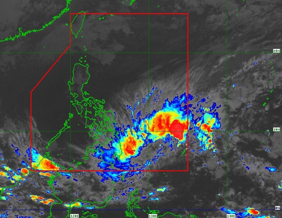
According to the Philippine Atmospheric, Geophysical and Astronomical Services Administration (PAGASA), at 16:00 on February 4, the center of the tropical depression Basyang was located in the Philippine Sea, about 655km east of Hinatuan town (Surigao del Sur province).
The strongest wind near the center reaches 55km/h, gusts up to 70km/h, central pressure is 1,002 hPa. This system is moving westward at a speed of about 15km/h and the strong wind area has a radius of up to 300km.
PAGASA has issued wind warnings of level 1 for many localities in Visayas and Mindanao, with the risk of strong winds in the next 36 hours.
In Mindanao, the islands of Dinagat, Surigao del Norte, Surigao del Sur, Agusan del Norte, Agusan del Sur, Camiguin, east of Misamis Oriental and north of Davao Oriental are directly affected.
Although the current warning level is assessed as "minimum to small", PAGASA emphasized that Basyang is likely to be raised to wind level 2 warning during migration, especially when the low pressure strengthens into a tropical storm.
In addition to strong winds, heavy rain is the most notable threat as Basyang approaches the mainland. The eastern and northeastern provinces of Mindanao are warned of the risk of prolonged heavy rain, which could cause flash floods and landslides in hilly and riverside areas.
The intensified northeast monsoon will also combine with the circulation of low pressure, causing strong to very strong winds in many places. Today and tomorrow, strong gusts of wind may occur in most of Luzon, Visayas and Mindanao, including urban areas like Metro Manila.
In the low and vulnerable coastal areas of the Dinagat Islands, Surigao del Norte, Surigao del Sur and Davao Oriental, the risk of storm surge is from minimum to moderate, with peak tides possibly reaching 2m in the next 48 hours.
At sea, strong wind warnings have been issued for the sea areas east of Visayas and Mindanao. Sea waves in Surigao del Sur can reach up to 5.5m; in Siargao and the Bucas Grande archipelago up to 5m. Many other areas along the east coast of the Philippines recorded waves from 3-4.5m high, posing great risks for all types of ships.
According to the current storm forecast scenario, Basyang will continue to move westward in the next 36 hours before turning west-northwest from the evening of February 5th. The center of Typhoon Basyang is forecast to make its first landfall in eastern Mindanao from the evening of February 5th to the morning of February 6th, then cross Mindanao, Central and Western Visayas, reaching the Sulu Sea on February 7th and entering the East Sea on February 8th.
This system has the potential to strengthen into a tropical storm in the Philippine Sea, but will weaken again when passing through land and may become a low pressure area on February 8 in the East Sea.
The Vietnam National Center for Hydro-Meteorological Forecasting said that on February 4, the northeast sea area of the northern East Sea has level 6 northeast wind, gusts of level 7-8; waves 3.0-5.0m high; rough seas.
The sea area from Khanh Hoa to Ho Chi Minh City and the sea area west of the southern East Sea (including the sea area west of Truong Sa special zone) has level 6 northeast wind, gusts of level 7-8; waves 2.0-4.0m high; rough seas.
On the night of February 4, the wind in the sea areas tends to gradually decrease.
Level of disaster risk at sea: Level 2.


