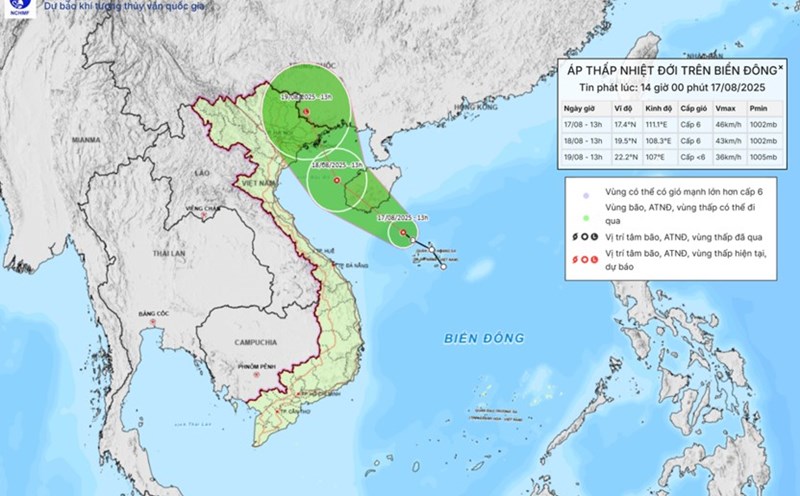
According to the storm/low pressure bulletin of the Philippine Atmospheric, Geophysical and Astronomical Services Administration, at 3:00 a.m. on August 21, the low pressure area was determined to be located about 705km east of Infanta, Quezon (Philippines) (14.6 degrees North latitude, 128.2 degrees East longitude).
Meanwhile, the US Joint Typhoon Warning Center (JTWC) said the system is associated with a large-scale tropical disturbance, moving slowly over the past 24 hours and has a favorable environment to develop into a tropical depression before crossing Luzon Island over the weekend.
The possibility of tropical depression/storm formation within the next 7 days has now been raised by the JTWC to a high of 70%. If it strengthens into a storm, the system will be named one one of the Philippines' fourth typhoons in August.
According to the forecast, on August 22-23, the low pressure area will cross Luzon to enter the East Sea. From August 23-25, the low pressure will tend to move in the West and West Northwest direction, heading straight to the sea area of Central - Northern Vietnam. The conditions in the East Sea are considered very favorable, so the possibility of the tropical depression strengthening into a storm cannot be ruled out.
In the most likely scenario, from the night of August 24 to August 25, the Northern and North Central provinces (from Thanh Hoa to Thua Thien - Hue) will be the areas directly affected. This is forecast to be the most severely affected area, with the risk of strong winds and heavy rain over a wide area, accompanied by a high risk of flash floods, landslides in mountainous areas and flooding in urban areas and low-lying areas.
The southwest monsoon combined with the tropical depression may cause prolonged heavy rain in the Central Highlands and the South, even though it is not in the direct landfall area.
The weather forecast bulletin of the Vietnam National Center for Hydro-Meteorological Forecasting said that on the day and night of August 21, in the North of the Gulf of Tonkin, the Central and South East Sea (including the special waters of Truong Sa), the waters from Gia Lai to Ca Mau, from Ca Mau to An Giang and the Gulf of Thailand, there will be scattered showers and thunderstorms. During thunderstorms, there is a possibility of tornadoes, strong gusts of wind of level 6-7 and waves 1-2m high.
Regarding rain forecast, in the afternoon and night of August 21, in the mountainous areas of the North, there will be rain, moderate rain and scattered thunderstorms, locally heavy to very heavy rain, common rainfall of 20-40mm, locally over 100mm.
Other areas of the North, Thanh Hoa, the South Central Coast, the Central and South Highlands will have scattered showers and thunderstorms, locally heavy rain, rainfall 15-30mm, locally over 80mm.
Regarding today's weather forecast in Hanoi: The lowest temperature is 25-27 degrees. The highest temperature is 32-34 degrees. Cloudy, sometimes with showers and thunderstorms, intermittent sunshine during the day. Southeast to south wind level 2-3. During thunderstorms, there is a possibility of tornadoes, lightning and strong gusts of wind.