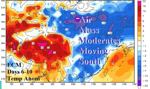
Forecasters from the China Meteorological Administration (CMA) note that Beijing is likely to enter winter early over the weekend and this sharp drop in temperatures will end the unusually hot spell in the eastern and southern provinces of the country.
Ma Xuekuan - Head of Forecasting Department of the National Meteorological Center (NMC) - said that the strong cold air mass is expected to move from north to south and continuously affect central and eastern provinces of China until October 21. Temperature in these areas is forecast to drop by 6 to 10 degrees Celsius.
Among the provinces and areas on the path of the strong cold air mass at the beginning of the season, the Inner Mongolia Autonomous Region and areas in central China are forecast to have temperatures drop by 10 to 14 degrees, even more than 15 degrees, during this time.
"This is the strongest cold spell to hit China in the second half of the year so far, in terms of scale and intensity," Ma Xuekuan said, warning temperatures in northern provinces of China to continue to drop next week.
Central China and provinces along the east bank of the Ha River and the Hoai Ha River, including Jiangsu, Anhui, Heinan and Shandong, are forecast to see temperatures drop by 10 degrees Celsius for five consecutive days from October 18, with a higher chance of winter starting.
Shi Xinxin - weather analyst of China Weather TV - said that there is a very high possibility that Beijing will see winter come early from October 18. The average daytime temperature in Beijing will drop below 10 degrees Celsius for 7 consecutive days from October 18.
From 1991 to 2020, China's capital began winter on October 31, but with the cold front taking place, the winter start date is expected to arrive earlier.
Experte Ma Xuekuan also pointed out that due to the influence of strong cold air, provinces and areas south of the Yangtze River and southern China such as Shanghai and Zhejiang also recorded a sudden drop in temperatures, ending the unusually hot weather here. From October 19 to October 24, temperatures in southern China will be 2 to 4 degrees Celsius lower than the same period in previous years.
The intersection between cold air masses and hot air flows also caused heavy rain in southwestern China and along the Ha River and the Hoai River such as Sichuan and Chongqing on October 23 and 24. The rain is forecast to gradually decrease from October 25 as the strong cold air mass moves deeper south.
The latest northeast monsoon news on October 19 from the Vietnam National Center for Hydro-Meteorological Forecasting said that the cold air mass is approaching the northern border of our country.
It is forecasted that in the afternoon and night of October 19, cold air will have a weak impact on the Northeast. From October 20-22, the cold air is forecast to strengthen strongly, spreading to the North Central region, then expanding to the Northwest and Central Central regions.
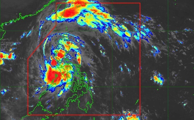
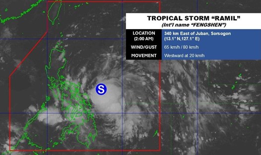
At sea, due to the influence of cold air combined with storm No. 12 Fengshen, the northern East Sea area has Northeast winds of level 6, gusting to 7-8, rough seas, waves 2.5-5m high. The Gulf of Tonkin from the evening of October 19 has northeast winds of level 6, gusting to 7-8, waves of 1.5-3m. Near the center of the storm Fengshen has winds of level 8-9, gusts of level 11, and very rough seas.