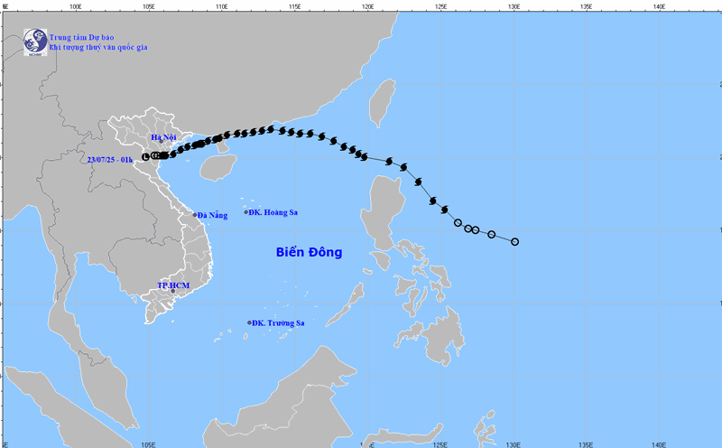
On July 23, according to information from the National Center for Hydro-Meteorological Forecasting, through monitoring on satellite images and weather satellite images, convective clouds are developing in the areas of the communes: Tam Hung, Thuong Tin, Dan Hoa, Thuong Phuc, Chuong Duong, Phuong Duc, Phu Xuyen. This convective cloud area tends to develop and expand towards the inner city of Hanoi.
In the next 30 minutes to 4 hours, the wards: Chuong My, Yen Nghia, Duong Noi, Ha Dong, Phu Luong, Kien Hung, Thanh Liet, Hoang Liet, Yen So, Linh Nam are likely to experience showers and thunderstorms. The thunderstorm area may continue to expand to other wards in Hanoi's inner city. During the rain, there is a possibility of tornadoes, lightning and strong gusts of wind.
The National Center for Hydro-Meteorological Forecasting warns that the water level in the coastal areas of the North is at a high level. The highest water level is forecast to reach 4.6m in Cua Ong, 4.1m in Hon Dau and 3.1m in Hon Ngu.
It is forecasted that low-lying areas in coastal areas, riverbanks, and areas outside the dike are likely to be flooded from 1 to 5 hours a day. High tides will slow down the flood drainage process on the river system in the area. In the morning, it is necessary to be on guard against strong currents heading far from the shore when the tide recedes, causing danger to maritime activities and marine tourism, especially at ports in and out of the sea and beaches.