Storm Forecast

The strongest super El Nino in history is 100% likely to appear this year
|
The latest data shows that there is a 100% chance of forming a super El Nino phenomenon this year.

Typhoon Hagupit strengthens further before approaching Philippine waters
|
Typhoon Hagupit may enter the Philippine forecast area this weekend.

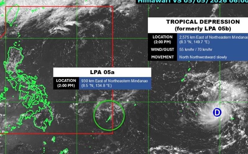
Low pressure enters the Philippines, thunderstorms forecast from tonight
|
The low pressure enters the forecast area of the Philippines and is forecast to cause thunderstorms in many places from the evening of May 6.

World 24h: Forecast of possibility of low pressure near the Philippines strengthening into a storm
|
Latest world news May 5th: Gold prices are still forecast to increase; 2 low pressures move towards the Philippines, possibly strengthening into Typhoon Caloy...
2 low pressure systems move towards the Philippines, possibly strengthening into Typhoon Caloy
|
Two low pressure systems are moving towards the Philippines, one of which enters the forecast area on May 5, while the other low pressure system is strengthening.

Low pressure outside the Philippines accelerates, may strengthen today
|
The low pressure area outside the forecast area of the Philippines is highly likely to strengthen into a tropical depression on May 5.

Forecast of thunderstorms in provinces and cities due to a new cold air wave, with heavy rain in some places
|
According to the meteorological agency, a new cold air mass is about to arrive, causing rain in the North, North Central and Central Central regions.

2026 storm season forecast is unpredictable, few but fierce
|
It is forecast that the 2026 storm season may be less than average, but just one strong storm making landfall is enough to cause serious consequences.

The first super typhoon of 2026 predicts a fierce storm season
|
Super typhoon Sinlaku is forecast to be the strongest in the world since Melissa made landfall in Jamaica in October 2025.

The world's strongest super typhoon Sinlaku intensifies rapidly, El Nino ignites disaster
|
Super typhoon Sinlaku surged from level 1 to level 5 in just 30 hours, devastating the US island and raising concerns about an extreme storm season due to El Nino.

Warning of the strongest El Nino in 140 years threatens to disrupt the 2026 storm season
|
Extremely strong El Nino - possibly in the strongest group in 140 years - is raising concerns about the disruption of storm paths in 2026.

Forecast of cold air causing thunderstorms in the North, ending hot weather
|
It is forecasted that cold air compressing a low pressure trough will cause rain in the North and Thanh Hoa from the night of April 16, the temperature will drop rapidly.

Extremely dangerous super typhoon threatens US territory
|
Super typhoon Sinlaku, assessed as extremely dangerous, is heading towards the Northern Mariana Islands, USA.

The world's strongest super typhoon Sinlaku is about to make landfall, high risk of disaster
|
Super typhoon Sinlaku - the strongest storm on the planet this year - is approaching US islands in the Western Pacific.

Warning of the worst El Nino risk in 140 years
|
Meteorologists are sounding the alarm about the risk of the worst El Nino in 140 years this year.