Forecast of low pressure and tropical cyclone appearing in the next 2 weeks

Châu Anh |

Weather forecast for the next 2 weeks records many whirlpools and low pressures.

The latest storm and low pressure news from the Philippine Atmospheric, Geophysical and Astronomical Services Administration (PAGASA) said that in the week from August 24-30, 3 tropical cyclones are being monitored, including tropical depression Gaenari, storm Saudel and tropical storm Atsani.

According to PAGASA's bulletin issued at 4:00 PM on August 24 (Philippines time), tropical depression Gaenari, formerly known as Neneng, is in the northwest of the Philippines and moving northwest at a speed of 10 km/h.

Meanwhile, Typhoon Saudel, locally known as Obet, is in the east-northeast of Northern Luzon and moving west-northwest.

Tropical storm Atsani is currently in eastern Luzon, moving in a northeast direction. PAGASA forecasts Atsani will weaken as it moves through the eastern edge of the Tropical Cyclone Warning (TCAD) area.

Besides the 3 existing monsoons, PAGASA forecasts a new monsoon zone with characteristics similar to a tropical monsoon (TCLV) that is likely to form on the eastern edge of the Philippine Area of Responsibility (PAR) and TCAD this week.

This vortex is numbered TCLV (1) and is likely to develop into a tropical cyclone at a low to medium level in the week from June 24-30. 8.

In the week from August 31st to September 6th, the risk of tropical cyclone formation is forecast to increase. PAGASA forecasts 3 TCLVs may form. Among them, TCLV (1) is forecast to appear on the northeastern edge of PAR and is likely to develop into a tropical cyclone at a high level.
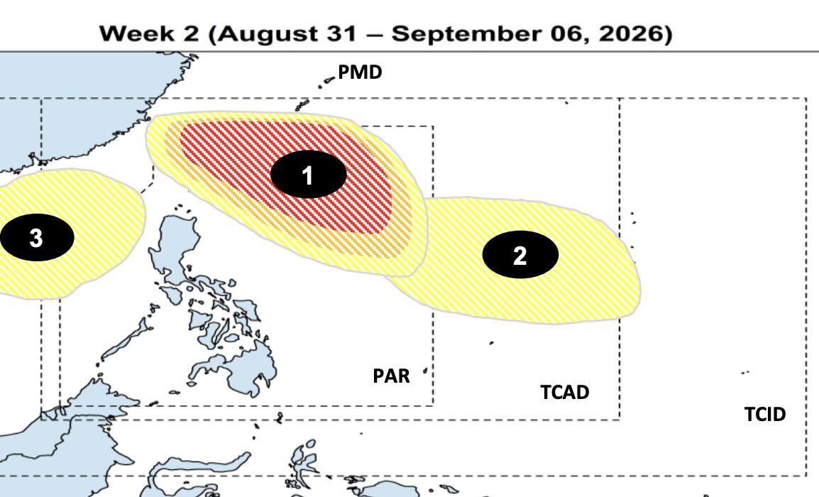
Ba vùng xoáy (số 1, 2, 3) được dự báo hình thành trong tuần từ ngày 31.8-6.9; vùng số 1 có khả năng phát triển thành xoáy thuận nhiệt đới ở mức cao. Ảnh: PAGASA
Three vorticles (No. 1, 2, 3) are forecast to form in the week from August 31st to September 6th; region No. 1 is likely to develop into a tropical cyclone at a high level. Photo: PAGASA

The remaining 2 cyclones are forecast to form in the Philippines' long-range forecast area (PMD), but both are likely to develop into low-level tropical cyclones.

Regarding climate trends, in August, tropical cyclones usually move north of PAR and then towards Taiwan (China) or divert to Japan. Some systems may pass through Luzon before moving towards China or Vietnam.

In September, tropical cyclones usually form in the east of PAR, moving northwest and then turning to Japan or South Korea. Some systems may pass through Northern Luzon or the Central - Southern Luzon region before heading south to China or Vietnam.

Châu Anh
RELATED NEWS

Low pressure has the potential to become a storm in the next 24 hours, risk of interaction with Typhoon Saudel

|

A newly discovered tropical depression is moving northeast, predicted to interact with Hurricane Saudel in the coming days.

2 low pressure areas are at risk of strengthening in the next 24 hours, heavy rain is forecast to increase

|

PAGASA warns that 2 low pressure areas are likely to strengthen in the next 24 hours.

New low pressure may form with 2 disturbance areas after Typhoon Saudel

|

PAGASA warns of a low pressure area that may form in the east of the Philippines, along with 2 other disturbance areas in the next 2 weeks.

Quach Mai Thy cries while practicing singing "Gánh mẹ" (Carrying Mother) preparing for the music night "Ơn nghĩa sinh thành" (Gratitude for Birth)

|

At the art program "Ơn nghĩa sinh thành 2026", Quach Mai Thy will duet with her husband in a new version of the song "Gánh mẹ".

Tornado in southern France damages 300 homes

|

A tornado has injured dozens of people and damaged hundreds of homes as it swept through southern France.

The strategy of Tinh Ha Say Hi when providing free music copyright at cafes and restaurants

|

The free music copyright fee of Tinh Ha Say Hi actually brings certain benefits to the producer.

Weather today August 25: Northern region reduces rain, highest 33 degrees C

|

Weather today August 25, the North has scattered showers and thunderstorms, locally heavy rain, intermittent sunny days with the highest temperature around 31 - 33 degrees C.

Hanoi basically thoroughly handles prolonged congestion points by 2030

|

Hanoi - One of the key tasks of the Hanoi Capital Master Plan with a 100-year vision is to basically thoroughly handle prolonged congestion points.

Low pressure has the potential to become a storm in the next 24 hours, risk of interaction with Typhoon Saudel

Châu Anh |

A newly discovered tropical depression is moving northeast, predicted to interact with Hurricane Saudel in the coming days.

2 low pressure areas are at risk of strengthening in the next 24 hours, heavy rain is forecast to increase

Châu Anh |

PAGASA warns that 2 low pressure areas are likely to strengthen in the next 24 hours.

New low pressure may form with 2 disturbance areas after Typhoon Saudel

Châu Anh |

PAGASA warns of a low pressure area that may form in the east of the Philippines, along with 2 other disturbance areas in the next 2 weeks.
