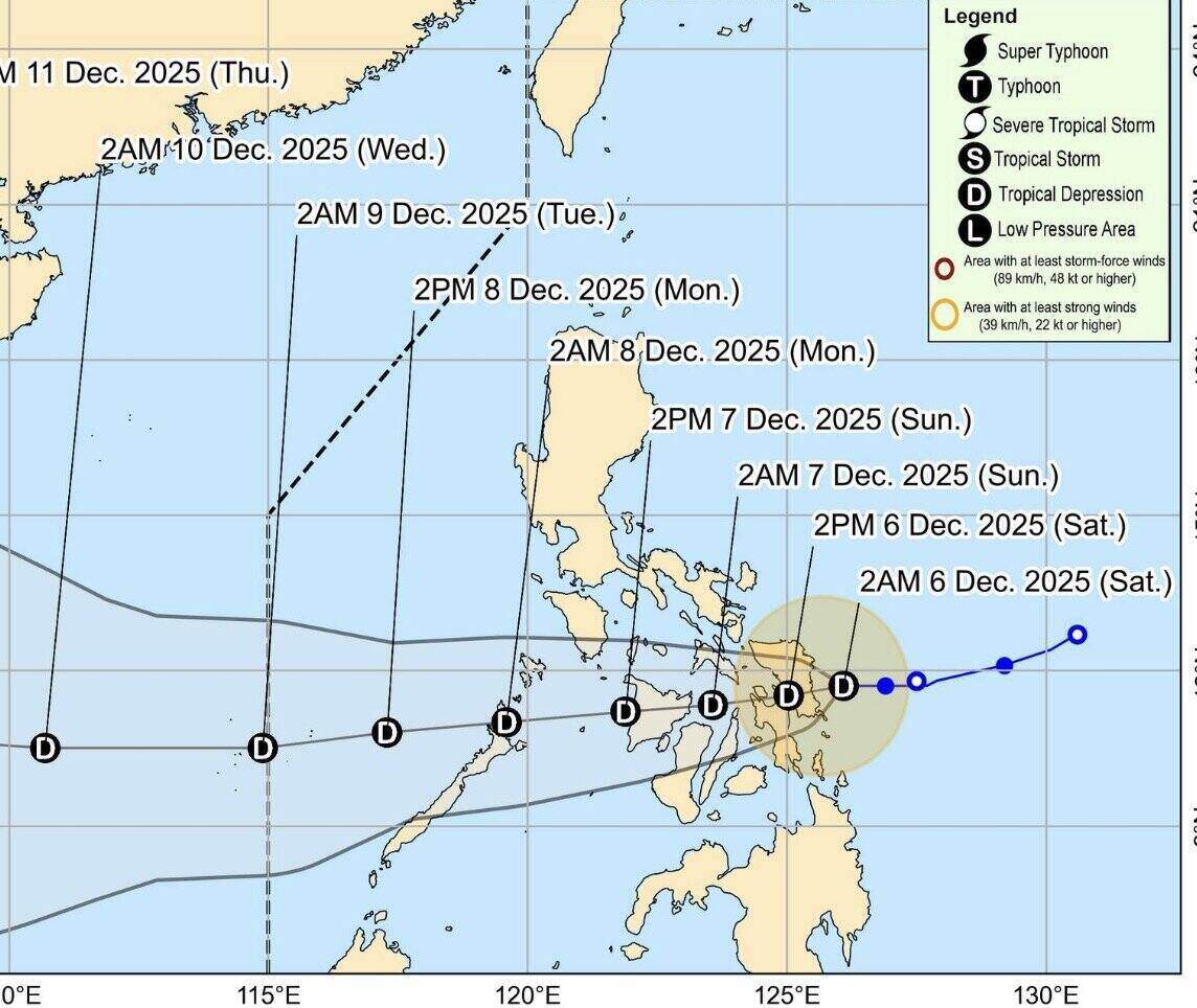
The latest storm and low pressure information on the morning of December 6 from the Philippine Atmospheric, Geophysical and Astronomical Services Administration (PAGASA) said that tropical depression Wilma has accelerated slightly and is expected to make landfall in Eastern Visayas, Philippines on December 6.
At 5 a.m., the center of tropical depression Wilma was 70 km east of Borongan City, Eastern Samar. The predecessor system of storm No. 16 in the East Sea is having the strongest sustained winds of 45 km/h near the center and gusts of up to 55 km/h. Wilma is moving west at 15 km/h.
Previously, at 11pm on December 5, tropical depression Wilma was about 135km east of Borongan City, Eastern Samar. At that time, this tropical depression near the East Sea was moving slowly westward and had the strongest sustained winds of 45 km/h, gusts of up to 55 km/h.
Tropical Depression Wilma is forecast to move mainly westward during the forecast period and may make landfall in Eastern Visayas. The predecessor of Typhoon No. 16 will then sweep the Visayas through December 7. Wilma will enter the Sulu Sea and may pass north of Palawan on the morning of December 8.
Forecasters in the Philippines say Wilma is likely to remain a tropical depression as it passes through Visayas and Southern Luzon. The ancestral system of storm No. 16 is forecast to strengthen further when it enters the East Sea on December 8.
In Luzon, Tropical Storm Warning No. 1 has been issued and taken effect for Sorsogon; Masbate, including Ticao and burias; Romblon; the southern part of Oriental Mindoro (Bulalacao, Mansalay, Roxas and Bongabong); the southern part of Occidental Mindoro ( Magsaysaysay, San Jose, Rizal and Calinta); and the northernmost part of Palawan ( Araceli, Dumaran, El Nido and Taytay) including Cuyo, Calamian and Cagayancillo Islands.
In the Visayas, Signal No. 1 due to the influence of tropical depression Wilma also applies to Northern Samar; Eastern Samar; Samar; Biliran; Leyte; South Leyte; Philippines; Bohol; Negros Occidental; Siquijor; the northern and central sections of Negros Oriental; Guimaras; Iloilo; Capiz; Aklan and Antique...
In the weather bulletin, PAGASA said that rains with gusts of wind will occur in the Visayas, Romblon, Masbate, Sorsogon, Camiguin, Surigao del Norte, Surigao del Sur, Agusan del Norte and Dinagat Islands due to the influence of Wilma.
Meanwhile, wind shear will bring scattered showers and thunderstorms to the remaining areas of Bicol, Quezon, Occidental Mindoro, Oriental Mindoro and Marinduque.
Flash floods and landslides can occur in these areas due to moderate to heavy rain, sometimes very heavy rain.
The Zamboanga Peninsula, the rest of Caraga and the rest of Northern Mindanao will see scattered showers and thunderstorms from Tropical Depression Wilma, while Cagayan Valley, Cordillera and Aurora will see northeast monsoons.


