Tropical depression in the East Sea likely to strengthen into a storm, forecast of affected area

Dương Anh |

Forecast for the next 24 hours, the tropical depression will move in a Southeast-east direction, at a speed of about 10-15 km/h, with the possibility of strengthening into a storm.

According to the National Center for Hydro-Meteorological Forecasting, at 7:00 AM on August 31, the center of the tropical depression was located at about 20.6 degrees North latitude; 110.3 degrees East longitude, over the southeast area of the Leizhou Peninsula (China).

The strongest wind near the center of the tropical depression is strong at level 7 (50-61km/h), gusting at level 9.

Forecast for the next 24 hours, the tropical depression will move in a Southeast-east direction, at a speed of about 10-15 km/h, with the possibility of strengthening into a storm.

By 7:00 AM on September 1st, the storm's center will be located at about 19.5 degrees North latitude; 113.2 degrees East longitude, over the northwestern sea area of the Northern East Sea. Intensity level 8, gusts level 10.

The dangerous area is located about 18.0 degrees North latitude; 109.5-114.5 degrees East longitude. The disaster risk level is level 3 for the northwestern sea area of the Northern East Sea.

Forecast for the next 48 hours, the storm will move in an East-Northeast direction, moving about 20km per hour.

By 7:00 AM on September 2nd, the storm's center will be located at about 21.9 degrees North latitude; 116.9 degrees East longitude, over the northeastern sea area of the Northern East Sea. Intensity level 8, gusts level 10.

The dangerous area is located about 18.0 degrees North latitude; 111.5-118.5 degrees East longitude. The disaster risk level is level 3 for the northern sea area of the Northern East Sea.

From the next 48 to 72 hours, the storm will move in a Northeast direction, moving about 10km per hour and gradually weakening into a tropical depression.
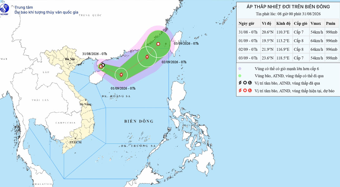
Dự báo khu vực ảnh hưởng do bão/áp thấp nhiệt đới trên biển Đông. Ảnh: Trung tâm dự báo khí tượng thủy văn Quốc gia.
Forecast of the area affected by storms/tropical depressions in the East Sea. Photo: National Center for Hydro-Meteorological Forecasting.

Regarding the impact of storms/tropical depressions at sea, the northwest sea area of the Northern East Sea has strong winds of level 6-7, gusts of level 8-9, sea waves of 2-4m high; the area near the storm center passing through is strong at level 8, gusts of level 10, sea waves of 3-5m high; strong rough seas.

Ships operating in the above-mentioned dangerous areas are likely to be affected by thunderstorms, tornadoes, strong winds, and large waves.

Dương Anh
RELATED NEWS

Forecast of the path of the tropical depression, likely to strengthen into a storm soon

|

Tropical depression Pilandok is moving slowly over the Philippine Sea and may strengthen into a storm in the afternoon of September 1 before leaving the Philippine forecast area.

East Sea forecast to be at risk of storms in early September

|

The National Center for Hydro-Meteorological Forecasting said that the sea weather has many notable developments during the September 2nd holiday; including the risk of storms.

Typhoon Saudel suddenly reappears, likely to continue to strengthen in the East Sea

|

Typhoon Saudel suddenly returned to the Philippines' monitoring area and is likely to strengthen over the South China Sea.

21 provinces and cities proactively respond to tropical depression with potential to strengthen into a storm

|

Many provinces and cities must proactively respond to tropical depressions that are likely to strengthen into storms and strong winds at sea.

Police focus on handling transport business vehicles, drivers intentionally violating safety distance

|

The Traffic Police Department said it will handle drivers who have been reminded and educated many times or have grasped the regulations but still try to violate safety distance.

Hanoi entertainment spots are crowded with visitors during the September 2nd holiday

|

During the National Day holiday on September 2nd, many entertainment venues in Hanoi recorded a sharp increase in the number of visitors, with some places experiencing full seats and out of tickets.

US - Iran clashes resume after a month

|

The US announced that it had attacked Iranian rocket launchers, causing Tehran to immediately respond.

White license plate cars disguised as combined cars run through holidays, competing to increase prices

|

During the September 2nd holiday, the demand for returning to their hometowns increased, many shared cars and white license plate buses operated, and ticket prices simultaneously increased on routes from Hanoi to provinces.

Forecast of the path of the tropical depression, likely to strengthen into a storm soon

Châu Anh |

Tropical depression Pilandok is moving slowly over the Philippine Sea and may strengthen into a storm in the afternoon of September 1 before leaving the Philippine forecast area.

East Sea forecast to be at risk of storms in early September

AN AN |

The National Center for Hydro-Meteorological Forecasting said that the sea weather has many notable developments during the September 2nd holiday; including the risk of storms.

Typhoon Saudel suddenly reappears, likely to continue to strengthen in the East Sea

Châu Anh |

Typhoon Saudel suddenly returned to the Philippines' monitoring area and is likely to strengthen over the South China Sea.
