East Sea storm news
Forecast of high risk of storm No. 15 in the East Sea at the end of November
|
A cluster of thunderstorms is likely to develop into a low pressure in the Philippines, strengthen into a storm and enter the East Sea, becoming the 15th storm at the end of November.

The predecessor of storm No. 15 is about to appear, forecasting the time of entering the East Sea
|
The new storm is likely to form and enter the East Sea, becoming the 15th storm of the week from November 21 to November 27.

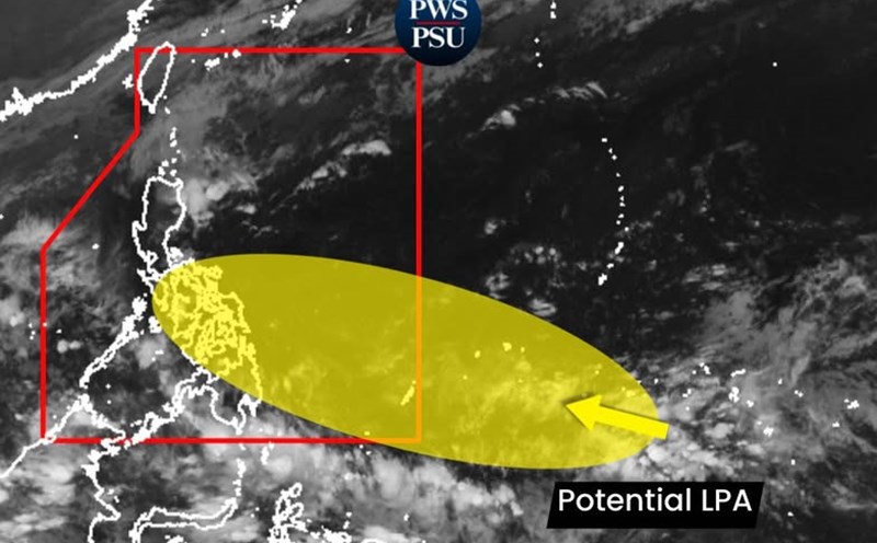
Forecast of high risk of forming storm Verbena near the East Sea
|
Storm forecast models warn of the possibility of a new storm appearing in the Philippines and the East Sea, with Verbena possibly the next storm name.

New low pressure will enter the East Sea, likely to become a storm
|
It is forecasted that 2 low pressure areas will form near the Philippines, including 1 low pressure area that is likely to become a storm and enter the East Sea.

The truth about the news of storm Verbena about to appear near the East Sea
|
After Typhoon No. 14 Fung-wong, there were rumors that new Verbena made landfall in the Philippines in November and the country's weather agency spoke up.

Forecast of when a new low pressure will enter the East Sea
|
The new low pressure is likely to form near the Philippines and enter the East Sea in the second half of November.

Storm No. 14 Fung-wong leaves the East Sea but continues to cause bad weather
|
Storm No. 14 Fung-wong left the East Sea this afternoon, November 12, but continued to cause strong winds and large waves in the northeastern sea area of the North East Sea.

Forecast of bad weather in the next 2 days due to cold air and storm No. 14
|
According to the meteorological agency, in addition to storm No. 14, a cold front is also about to affect the weather at sea.

Storm No. 14 with gusts of level 11 will gradually weaken, about to leave the East Sea
|
According to the meteorological agency, storm No. 14 is still active in the northeastern sea of the northern East Sea, but its intensity has decreased to level 8-9, gusting to level 11.

Forecast of bad weather in the next 2 days due to storm No. 14 Fung-wong
|
Although Typhoon No. 14 Fung-wong is weakening, it continues to cause unfavorable weather at sea, especially in the eastern sea area of the northern East Sea.

Storm No. 14 Fung-wong moves slowly, weakens but is still very strong in the East Sea
|
According to the meteorological agency, the intensity of storm No. 14 Fung-wong has decreased to level 12, gusting to level 15 in the eastern sea area of the North East Sea.

Storm No. 14 Fung-wong gusts to level 16 in the next 24 hours before continuing to change direction
|
According to the meteorological agency, in the next 24 hours, storm No. 14 Fung-wong is forecast to move slowly, maintaining an intensity of level 13 gusting to level 16 in the eastern sea area of the northern East Sea.

Storm No. 14 Fung-wong continues to gust to level 16 in the next 24 hours, waves 5-10m high
|
According to the meteorological agency, storm No. 14 Fung-wong will continue to maintain very strong intensity, around level 13, gusting to level 16 in the next 24 hours before weakening rapidly.

Storm No. 14 Fung-wong is very strong in the East Sea, forecasting bad weather in the next 2 days
|
Due to the impact of storm No. 14 Fung-wong, the sea area east of the northern East Sea will have storms, the east of the central East Sea will have showers and thunderstorms.

Storm No. 14 Fung-wong enters the East Sea, targeting a new landing area
|
Typhoon No. 14 Fung-wong is forecast to make landfall in Taiwan (China) after sweeping the northeastern Philippines on the night of November 9.