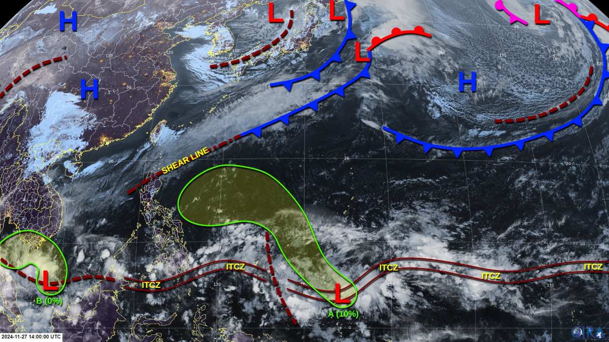
The latest storm/low pressure information on November 27, 2024 from the Philippine Atmospheric, Geophysical and Astronomical Services Administration (PAGASA) said that during the week from November 27 to December 3, 2024, a low pressure area may appear in the southern part of the South China Sea (West Philippine Sea) and a low pressure area may form near Eastern Visayas and Mindanao, within the Philippine forecast area (PAR).
Meanwhile, according to the Pacific Typhoon Season page, there is currently a weak low pressure area (Tropical Depression A) southeast of Yap (one of the four states in the Federated States of Micronesia), bringing showers. While current environmental conditions are quite favorable for development, the low will move northwest into a much more severe environment through the weekend.
Any further development looks likely to be slow, before drier air and stronger upper-level winds end the low's chances of development over the weekend. The 7-day chance of strengthening is low at just 10%.

Another weak depression (Down Pressure B) between Borneo and the Malay Peninsula continues to produce a large area of showers and thunderstorms in the southern South China Sea. Upper-level winds are becoming unfavorable and further development appears unlikely as the depression moves over the southern South China Sea and the Gulf of Thailand.
While this depression is unlikely to become a tropical storm, it is expected to produce heavy rains over parts of Vietnam, Thailand, Malaysia and Indonesia over the next few days. Heavy rains could cause widespread flooding. The chance of the depression intensifying over the next 7 days is 0%.
Regarding the La Nina phenomenon, PAGASA said there is a high possibility - 74% probability - that a weak La Nina will develop between December and January.
"The La Nina warning continues, with La Nina-like conditions currently prevailing in the tropical Pacific Ocean," said Ana Solis, director of PAGASA's weather forecasting and climate monitoring division.
Weak La Nina is expected to last until the first quarter of 2025 and strong La Nina is unlikely to occur at that time.
Regarding the rainfall forecast for December, Ms. Solis said some areas in the Philippines will have near-to-above-normal rainfall, concentrated in the eastern part of the country.
Rainfall in December will be caused by a variety of weather systems, including the northeast monsoon, possible tropical storms and localized thunderstorms.
Overall, near-to-above-normal rainfall is also forecast in January, especially in the Bicol and Eastern Visayas regions, as well as some parts of Mimaropa and Southern Luzon.
A low pressure area, a potential tropical storm and an intertropical convergence zone are likely to bring rainfall in January, Solis said.
The Philippines may experience 1 to 2 tropical storms in December. Between 2 and 8 tropical storms are expected from December to May.


