Rumors of 6 typhoons near the East Sea this week, the Philippines speaks out

Thanh Hà |

The Philippine State Weather Agency confirmed that the information about 6 storms near the East Sea forming this week is untrue.

The latest typhoon information on July 23 from the Philippine Atmospheric, Geophysical and Astronomical Services Administration (PAGASA) has denied information about 6 tropical storms hitting the Philippines this week.

PAGASA called on the public to pay attention to fake news and share a screenshot of the post on the Facebook page "Bulacan RC Crayfish" with PAGASA's logo. The post on this page predicts that 6 typhoons Dante, Emong, Fabian, Gorlo, Huaning and one one will enter the Philippines on July 24.

"The widespread information that 6 tropical storms will make landfall in the Philippines this week is untrue," PAGASA stressed.

In the bulletin, PAGASA also noted that the low pressure area east of Aurora strengthened into tropical depression Dante on the afternoon of July 22 and has now strengthened into a tropical storm.

PAGASA Assistant Director Chris Perez said that based on the current forecast track, Dante is unlikely to make landfall or directly affect the Philippines.

Dante storm is 880km east of Luzon, with a wind of 65 km/h and 80 km/h.

4 he thong gom bao, ap thap nhiet doi va ap thap dang duoc theo doi gan Bien Dong. Anh: Zoom Earth
Four systems including storms, tropical depressions and depressions are being monitored near the East Sea. Photo: Zoom Earth

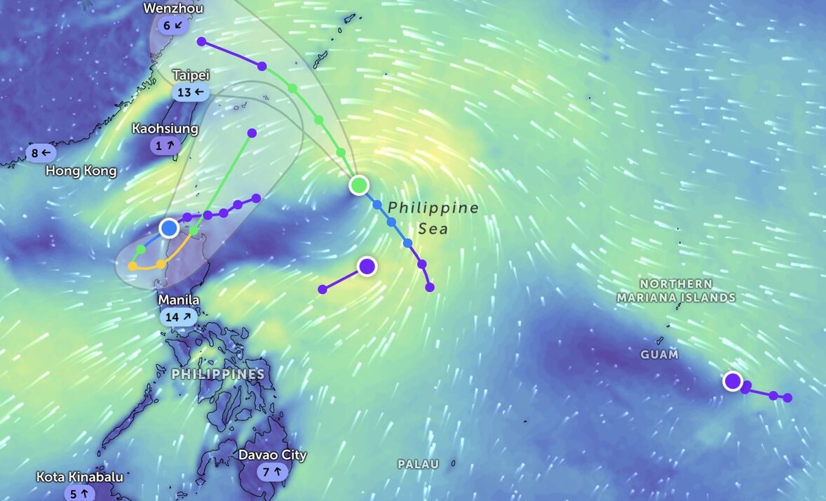
Philippine typhoon forecasters point out that sub subtropical storm subtropical and northwest of the Philippine Sea will move northwestward until it leaves the Philippine forecast area late on July 24 or early on July 25.

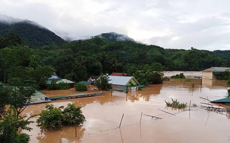
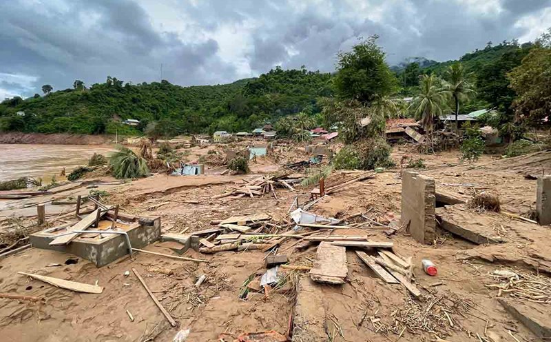
Dante storm is expected to not hit the mainland and no wind signals are issued regarding the storm. However, the latest storm near the East Sea forecasts to increase the Southwest monsoon, bringing significant rainfall on Luzon and Western Visayas Island until the end of July 25.

Heavy rains are possible in Pangasinan, Zambales, Bataan and Occidental Mindoro on July 23 and 24.

The risk of flooding and landslides remains in these areas, especially after last week's rain.

PAGASA said that the low pressure area near the East Sea, off the northern tip of Luzon, developed into tropical depression Emong on the morning of July 23. Emong is 105km northwest of Northern Luzon, with maximum sustained winds of 45km/h and gusts of up to 55km/h.

In addition to Typhoon Dante and Tropical Depression Emong, PAGASA is also monitoring another low pressure area 2,340 km east of Eastern Visayas.

Tropical Depression Emong is designated by the US Navy's Joint Typhoon Warning Center (JTWC) as Tropical Depression 11W. According to the forecast track of the JTWC, this tropical depression is likely to enter the East Sea and strengthen into a storm before returning to the Philippines. The JTWC said that tropical depression 11W is 470km north of Manila, Philippines. The system has been moving west-southwest at a speed of 19 km/h for the past 6 hours.

In addition to the three systems similar to those monitored by PAGASA, the JTWC is monitoring a fourth weather system that has just formed near the Philippines - the Invest 90W depression currently operating in the Philippine Sea, near the area where Hurricane Dante forms. Currently, Invest 90W is unlikely to strengthen into a tropical depression within the next 24 hours.

Thanh Hà
TIN LIÊN QUAN

Tropical depression Dante appears, can be consolidated with low pressure near the South China Sea

|

Tropical depression Dante formed on the afternoon of July 22 and is likely to consolidate with another low pressure near the South China Sea.

Low pressure appears in large numbers near the East Sea, exceeding the forecast speed of experts

|

The third low pressure near the East Sea appeared on the morning of July 22, marking 3 consecutive days of a new low pressure appearing right after Typhoon Wipha.

Low pressure appears near the East Sea as storm Wipha is moving into the Gulf of Tonkin

|

The low pressure near the East Sea appeared from the night of July 20 in the context of Typhoon Wipha active in the East Sea.

No alcohol or drug concentration was detected in the driver who caused the accident on Kham Thien Street

|

The incident of a pickup truck losing control caused a series of accidents in Hanoi, injuring 1 person and damaging 9 motorbikes, the driver was negative with alcohol and drug levels.

The circulation of storm No. 3 caused heavy damage in many provinces, thousands of people were evacuated

|

Bac Ninh, Hung Yen, Nghe An, Thanh Hoa... recorded serious damage to people and property due to heavy rain, thunderstorms and landslides from the circulation of storm No. 3.

20h News: Pain and tears for losing property due to floodwaters

|

powerlessly seeing all their assets lost in floodwaters; Inside the illegal gold mine in the middle of Quang Tri forest, the army surveyed to destroy...

More than 200 houses in a border commune of Nghe An were destroyed by floods

|

Nghe An - Affected by storm No. 3, major floods have severely damaged and swept away 231 houses in the border commune of My Ly.

Checking food at Unico Global YB Company after the case of a foreign object that giong nhu a robot in a rice tray

|

Lao Cai - The Provincial Labor Federation has just inspected food and meal quality at the Company and discovered unusual foreign objects in the workers' rice tray.

Tropical depression Dante appears, can be consolidated with low pressure near the South China Sea

Thanh Hà |

Tropical depression Dante formed on the afternoon of July 22 and is likely to consolidate with another low pressure near the South China Sea.

Low pressure appears in large numbers near the East Sea, exceeding the forecast speed of experts

Thanh Hà |

The third low pressure near the East Sea appeared on the morning of July 22, marking 3 consecutive days of a new low pressure appearing right after Typhoon Wipha.

Low pressure appears near the East Sea as storm Wipha is moving into the Gulf of Tonkin

Thanh Hà |

The low pressure near the East Sea appeared from the night of July 20 in the context of Typhoon Wipha active in the East Sea.