Storm No. 9

Super typhoon Ragasa makes landfall, 12m high waves appear in the Philippines
|
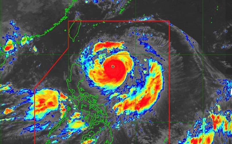
On the afternoon of September 22, super typhoon Ragasa swept into the northern Philippines with winds of 215-260 km/h, gusting over 295 km/h.

Super typhoon Ragasa makes landfall with destructive winds of 295 km/h, about to enter the East Sea
|
On the afternoon of September 22, super typhoon Ragasa made landfall in the northern Philippines, with gusts of up to 295 km/h.

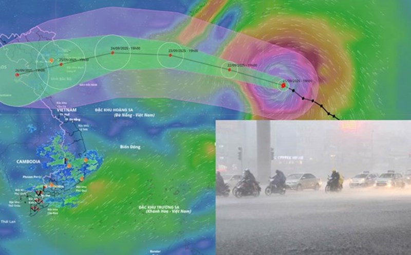
There is still a bad scenario for the path of super typhoon No. 9 Ragasa, expected to be strongly affected provinces
|
Although there are two different scenarios for the path of super typhoon Ragasa, all predict that the affected areas will be the North and North Central regions.

Super typhoon No. 9 Ragasa maintains maximum intensity of level 17 when entering the East Sea tonight
|
According to the meteorological agency, super typhoon Ragasa will still maintain its maximum intensity of level 17, gusting above level 17 when entering the East Sea tonight, September 22.
Storm No. 9 Ragasa is extremely strong, the Ministry of Education and Training urgently directs
|
In the face of the complicated developments of storm No. 9, the Ministry of Education and Training requires localities from Lam Dong and above to prepare online learning plans and temporarily postpone school schedules.

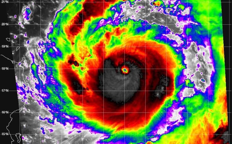
Super typhoon Ragasa shows giant eye, rolling straight into the East Sea
|
Satellite imagery shows the giant eye of super typhoon Ragasa with a diameter of more than 70km. It is forecasted that in less than 72 hours, the storm will approach the coast of Vietnam.

Super typhoon No. 9 Ragasa is one of the strongest super typhoons to appear in the East Sea
|
According to the representative of the meteorological agency, with a maximum intensity of level 16-17, gusting above level 17 when entering the East Sea; super typhoon Ragasa is among the strongest super typhoons ever to appear in the East Sea.

Warning provinces of the risk of thunderstorms and tornadoes before super typhoon No. 9 Ragasa makes landfall
|
A representative of the meteorological agency warned that special attention should be paid to thunderstorms and tornadoes when super typhoon No. 9 Ragasa is still 300-400km from the mainland.
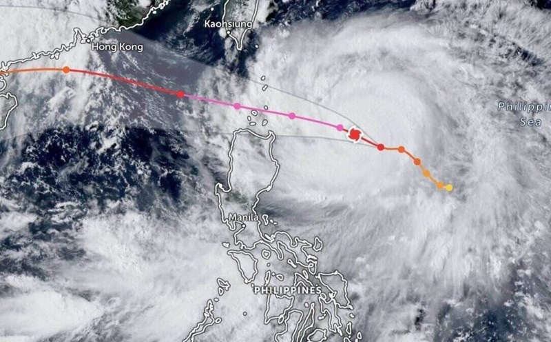
Super typhoon Ragasa rapidly intensifies, forecast to have a maximum impact at 8:00 a.m. tomorrow morning
|
On September 21, as super typhoon Ragasa approached, the Philippines and Taiwan (China) issued evacuation orders due to the risk of flooding and landslides.
Super typhoon Ragasa forms, forecast of first landfall time
|
Super typhoon Ragasa (called Nando in the Philippines) officially formed on the morning of September 21.
Super typhoon near the East Sea forms, forecast area of most severe impact
|
Potential storm No. 9 in the East Sea - storm Ragasa is rapidly intensifying - has strengthened into a super typhoon with a direction towards North Central Vietnam.

Storm No. 9 has the potential to rapidly strengthen, about to become a super typhoon before entering the East Sea
|
Typhoon Ragasa is rapidly strengthening, forecast to reach super typhoon level before entering the East Sea and becoming the ninth typhoon of 2025.

Super storm No. 9 in the East Sea has not yet formed, and the new super typhoon has broken
|
It is forecasted that right after potential super typhoon No. 9 Ragasa in the East Sea, there may be another super typhoon Neoguri.

12 hours to go until Typhoon No. 8 Mitag makes landfall, likely to welcome Typhoon No. 9 Ragasa
|
According to the meteorological agency, in the next 12 hours, storm No. 8 Mitag is forecast to gradually weaken into a tropical depression, entering the mainland in the south of Guangdong province (China).

Storm Ragasa is very strong, about to increase rapidly to level 17, at risk of entering the East Sea
|
Typhoon Ragasa is currently strong at level 8, gusting to level 10; it may increase to level 14 - 15, gusting above level 17 in the next 3 days.