The latest storm and low pressure information from the Philippine Atmospheric, Geophysical and Astronomical Services Administration (PAGASA) on the morning of November 5 said that the tropical depression outside the Philippine Forecast Area (PAR) is 1,830km east of southeast Mindanao.
The low pressure area that is potential to strengthen into a super typhoon is currently experiencing maximum sustained winds of 55 km/h, gusts of 70 km/h and is moving south-southeast at a speed of 20 km/h.
Meanwhile, the Taiwan Weather Forecast Agency (CWA) said that the tropical depression in the east of the Philippines is expected to strengthen into a tropical storm as early as today (November 5).
When it strengthens into a storm, the system will be named Fung-wong - the 26th storm of this year's Pacific typhoon season. In the Philippines, when it enters the PAR, the system will be locally named Typhoon Uwan.
Notably, the CWA warned that as it approaches the Philippines, Fung-wong is expected to strengthen into a typhoon before the end of this week and will have an important turning point in the storm's path on November 10.
Accordingly, this potential super typhoon may curve north towards the sea east of Taiwan (China) or continue to move westward through the Philippines, entering the East Sea, depending on atmospheric conditions.
According to Taiwanese weather forecasters, the northeast wind will continue to bring rain to the island's northern coast, as well as the mountainous areas of Taipei and Yiling Province on November 5. Weak winds are forecast on November 6, leading to less rain.
A new northeast wind is forecast to form from November 9, causing localized showers to northern and northeastern Taiwan (China) and may last until next week.
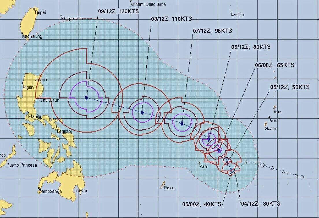
The US Navy's Joint Typhoon Warning Center (JTWC) calls the tropical depression near the Philippines 32W. 32W is 94km northwest of the Woleai Islands in the Pacific Ocean, moving west at 24km/h.
If it continues to move as expected, the JTWC forecasts that the storm will move northwest in the coming days, reaching its peak as a Category 4 typhoon in the afternoon of November 9 when it is nearly 700km east of Metro Manila, Philippines.
The latest storm forecast from the JTWC said that the potential tropical depression to strengthen into Typhoon Fung-wong has moved slightly south, with the possibility of making landfall in the Isabela-Aurora area, Philippines on the morning of November 10.
Previously, forecast models showed that Typhoon Fung-wong could move northwest straight toward Luzon, the Philippines and Taiwan (China) or northeast, bending toward Ishigaki and Miyako in southwestern Japan.


